- Copake, New York
-
Copake, New York — Town — [[File: |250px|none|alt=|]]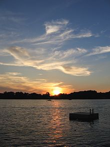
 Location within the state of New York
 Copake, New York
Coordinates: 42°8′2″N 73°34′6″W / 42.13389°N 73.56833°W Country United States State New York County Columbia Government – Type Town Council – Town Supervisor Reginald Crowley (R) – Town Council Members' ListArea – Total 42.1 sq mi (109.1 km2) – Land 41.0 sq mi (106.1 km2) – Water 1.2 sq mi (3.0 km2) Elevation 568 ft (173 m) Population (2000) – Total 3,278 – Density 80.0/sq mi (30.9/km2) Time zone Eastern (EST) (UTC-5) – Summer (DST) EDT (UTC-4) ZIP codes 12516, 12593 Area code(s) 518 FIPS code 36-18102 GNIS feature ID 0978865 Copake is a town in Columbia County, United States. New York, United States. The population was 3,278 at the 2000 census. The town derives its name from a lake, which was known to the natives as Cook-pake, or Ack-kook-peek,[1] meaning "Snake Pond." The town borders Taconic State Park.
The Town of Copake is on the south eastern border of the county.
Contents
History
Copake is part of the 1686 Taconic Grant to Robert Livingston for about 400 acres (1.6 km2) of good land and 2,200 acres (8.9 km2) of woodland. After it was purchased from the Indians it turned out to be 160,000-acre (650 km2) and he established the English style Livingston Manor. The Manor extended well into what is now Massachuetts. The first lease given by Livingston in Copake was for about 85 acres (340,000 m2) in 1687 to Matthews Abraham Van Deusen. Because New England claimed ownership west to the Hudson River a border dispute broke out. The Boston Bay Colony laid out three townships west of the Taconic Mountains in 1755. Most of the present Town of Copake was in one of the townships. New settlers were given 100 acres (0.40 km2) free and some of Livingston’s tenants refused to pay rent. The border was settled in 1757 by the Lords Commissioners of Trade in London. Farmers west of the border continued to protest, however. In 1844 a rally organized by the Taconic Mutual Association took place in the center of the hamlet. After the rally the arrest of several of the leaders sparked wider protests. Eventually the Anti-Rent Party was formed in New York State and New York instituted land reform. The Anti-Rent Party called for a Homestead Act to develop the western land. It became part of the Republican Party and was important in the election of Lincoln in 1860. The Township of Copake was formed in 1824 by splitting it from the Town of Granger that was renamed Taghkanic. A former early industry was iron mining and smelting. Adjacent to the village of Copake Falls in Taconic State Park is the "Ore Pit", a former iron mine, now a 40-foot (12 m) deep swimming pond.
Former residents of note
Henry Astor had a home in West Copake. Mariah Carey had a home in Craryville, located on the ourskirts of Copake.
Geography
According to the United States Census Bureau, the town has a total area of 42.1 square miles (109 km2), of which, 41.0 square miles (106 km2) of it is land and 1.2 square miles (3.1 km2) of it (2.75%) is water.
The town is easily accessible from New York City via the Taconic State Parkway or NY RT 22 and is a popular destination for second home owners escaping busy Manhattan. Metro-North Railroad is also located about 20 minutes south of the town with service to and from Grand Central Terminal.
The east town line is the border of Berkshire County, Massachusetts.
Demographics
As of the census[2] of 2000, there were 3,278 people, 1,280 households, and 869 families residing in the town. The population density was 80.0 people per square mile (30.9/km²). There were 2,185 housing units at an average density of 53.3 per square mile (20.6/km²). The racial makeup of the town was 96.55% White, 0.70% African American, 0.46% Native American, 0.12% Asian, 0.58% from other races, and 1.59% from two or more races. Hispanic or Latino of any race were 2.29% of the population.
There were 1,280 households out of which 27.2% had children under the age of 18 living with them, 54.3% were married couples living together, 8.4% had a female householder with no husband present, and 32.1% were non-families. 25.9% of all households were made up of individuals and 11.7% had someone living alone who was 65 years of age or older. The average household size was 2.45 and the average family size was 2.89.
In the town the population was spread out with 21.4% under the age of 18, 6.1% from 18 to 24, 28.1% from 25 to 44, 26.2% from 45 to 64, and 18.3% who were 65 years of age or older. The median age was 42 years. For every 100 females there were 104.7 males. For every 100 females age 18 and over, there were 101.5 males.
The median income for a household in the town was $42,261, and the median income for a family was $46,544. Males had a median income of $32,004 versus $25,341 for females. The per capita income for the town was $23,088. About 6.5% of families and 8.1% of the population were below the poverty line, including 11.8% of those under age 18 and 4.5% of those age 65 or over.
Communities and locations in Copake
- Camphill Village – A therapeutic community for developmentally disabled adults.
- Copake (formerly "Copake Flats") – The hamlet of Copake is in the south part of the town.
- Copake Falls – A hamlet north of Copake village.
- Copake Iron Works – A former community in the town, now in the state park.
- Copake Lake – The name of 1: a lake on the western town line; 2: a community within the cdp.
- Craryville (formerly "Bains Corner") – A hamlet in the northwest part of the town.
- Taconic Shores – A community (property owners association) northwest of Copake village encircling Robinson Pond.
- Taconic State Park –
- Weedmines – A location at the south town line.
- West Copake (formerly "Andersons Corners") – A hamlet in the southwest part of the town and southwest of Copake village.
References
- ^ Aboriginal place names of New York, By William Martin Beauchamp, page 46
- ^ "American FactFinder". United States Census Bureau. http://factfinder.census.gov. Retrieved 2008-01-31.
External links
- Town of Copake, NY
- Information about Copake, NY
- Copake Falls state park
- Historical information about Copake
- Roe-Jan Community Library
Coordinates: 42°06′12″N 73°33′00″W / 42.10333°N 73.55°W
Municipalities and communities of Columbia County, New York City 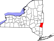
Towns Ancram | Austerlitz | Canaan | Chatham | Claverack | Clermont | Copake | Gallatin | Germantown | Ghent | Greenport | Hillsdale | Kinderhook | Livingston | New Lebanon | Stockport | Stuyvesant | Taghkanic
Villages Chatham | Kinderhook | Philmont | Valatie
CDPs Other
hamletsBoston Corner‡ | East Chatham | Old Chatham | Stuyvesant Falls
Footnotes ‡This populated place also has portions in an adjacent county or counties
Categories:- Towns in New York
- Populated places in Columbia County, New York
- Place names in New York of Native American origin


Wikimedia Foundation. 2010.