- New York State Route 344
-
NYS Route 344
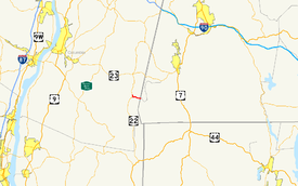
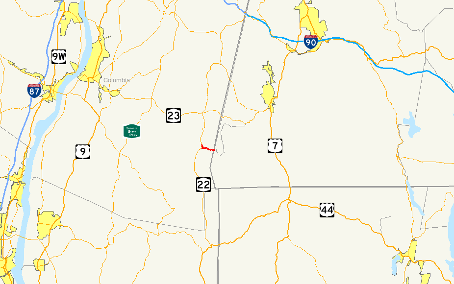
Map of the Copake Falls area with NY 344 highlighted in redRoute information Maintained by NYSDOT Length: 1.90 mi[3] (3.06 km) Existed: ca. 1932[1][2] – present Major junctions West end:  NY 22 in Copake
East end: Falls Road at Copake Location Counties: Columbia Highway system Numbered highways in New York
Interstate • U.S. • N.Y. (former) • Reference • County←  NY 343
NY 345  →
→New York State Route 344 (NY 344) is a state highway located in Columbia County, New York, United States. The route is 1.90 miles (3.06 km) in length and serves primarily as an access road to the Bash Bish Falls state parks on both sides of the New York – Massachusetts border. The western terminus of NY 344 is at NY 22 in Copake. Its eastern terminus is at the Massachusetts state line, where it continues into Bash Bish Falls State Park as Falls Road, a locally-maintained highway. NY 344 was assigned ca. 1932 and extended to its current length by 1953 after NY 22 was rerouted to bypass Copake Falls.
Contents
Route description
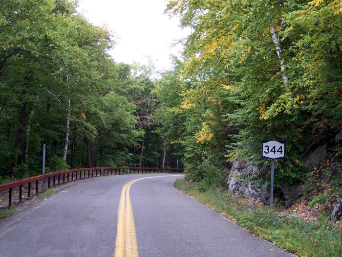
 First reassurrance shield westbound on NY 344
NY 344 begins at an intersection with NY 22 in the hamlet of Copake Falls. The road heads to the southeast, turning eastward into Taconic State Park. NY 344 intersects with a few local roads at the border of the park, where it runs along the base of Sunset Rock, an 1,800 feet (550 m) high, dual state mountain. The route continues eastward, along the base of Cedar Mountain before beginning to ascend up the mountain. While climbing Cedar Mountain, NY 344 crosses into Massachusetts and becomes the unnumbered Falls Road, a local roadway providing access to Bash Bish Falls State Park.[4]
History
NY 344 was assigned ca. 1932 to a 1.52-mile (2.45 km) long highway extending from Copake Falls in the west to the Massachusetts state line in the east.[1][2][5] At the time, NY 22 served Copake Falls directly instead of bypassing it.[2] NY 22 was rerouted to bypass Copake Falls on a new roadway to the west of the hamlet between 1947 and 1953. NY 344 was then extended northward on NY 22's former alignment to meet the new bypass north of Copake Falls.[6][7] The southern half of NY 22's old routing into the hamlet remained state-maintained as well and is now NY 980F, an unsigned reference route.[8]
Major intersections
The entire route is in Copake, Columbia County.
Mile[3] Destinations Notes 0.00 NY 221.90 Falls Road Continuation into Massachusetts 1.000 mi = 1.609 km; 1.000 km = 0.621 mi References
- ^ a b Kendall Refining Company (1931). New York (Map). Cartography by H.M. Gousha Company.
- ^ a b c Texas Oil Company (1932). Texaco Road Map – New York (Map). Cartography by Rand McNally and Company.
- ^ a b "2008 Traffic Data Report for New York State" (PDF). New York State Department of Transportation. June 16, 2009. p. 296. https://www.nysdot.gov/divisions/engineering/technical-services/hds-respository/NYSDOT_Traffic_Data_Report_2008.pdf. Retrieved December 9, 2009.
- ^ Google, Inc. Google Maps – overview map of NY 344 and Falls Road (Map). Cartography by Google, Inc. http://maps.google.com/maps?sourceid=navclient&ie=UTF-8&rlz=1T4ADBF_enUS232US232&q=from%3A%20RT-344%20%4042.125566%2C%20-73.525332%20to%3A%20Falls%20Rd%20%4042.111788%2C%20-73.473023&um=1&sa=N&tab=wl. Retrieved May 1, 2008.
- ^ Yahoo! Inc. Yahoo! Maps – overview map of NY 344's original alignment (Map). Cartography by NAVTEQ. http://maps.yahoo.com/#mvt=m&lat=42.115096&lon=-73.499177&zoom=17&q1=42.120198%2C-73.524025&q2=42.115964%2C-73.497117. Retrieved July 8, 2008.
- ^ Army Map Service (1947). Albany, United States Quadrangle (Map). 1 : 250,000. Eastern United States 1 : 250,000. http://www.lib.utexas.edu/maps/topo/250k/txu-pclmaps-topo-us-albany-1947.jpg. Retrieved May 2, 2008.
- ^ United States Geological Survey (1953). Copake Quadrangle - New York-Massachusetts (Map). 1 : 24,000. 7.5 Minute Series (Topographic). http://www.nysgis.state.ny.us/gisdata/quads/drg24/usgspreview/index.cfm?code=o42073a5. Retrieved May 2, 2008.
- ^ New York State Department of Transportation (January 2009) (PDF). Official Description of Highway Touring Routes, Bicycling Touring Routes, Scenic Byways, & Commemorative/Memorial Designations in New York State. https://www.nysdot.gov/divisions/operating/oom/transportation-systems/repository/2009%20tour-bk.pdf. Retrieved May 2, 2008.
External links
Categories:- State highways in New York
- Transportation in Columbia County, New York

Wikimedia Foundation. 2010.