- County Route 149 (Sullivan County, New York)
-
County Route 149
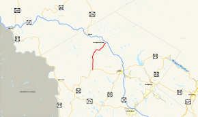
Map of Sullivan County and vicinity with CR 149 highlighted in redRoute information Length: 8.70 mi[2] (14.00 km) Existed: by 1995[1] – present Major junctions West end:  NY 52 in Youngsville
East end: CR 178 in Livingston Manor Highway system Numbered highways in New York
Interstate • U.S. • N.Y. (former) • Reference • County (Sullivan)County Route 149 (CR 149) in Sullivan County, New York is a county highway that was once maintained by the New York State Department of Public Works. The route, 8.70 miles (14.00 km) long, runs from an intersection with New York State Route 52 (NY 52) in the community of Youngsville, New York to an intersection with CR 178 in the community of Livingston Manor.
The route was originally designated as New York State Route 284 during the 1930s. The Sullivan County Highway Department had designated the former routing of NY 284 as CR 149 by 1995.
Contents
Route description
CR 149 begins at an intersection with NY 52 in the community of Youngsville. The route progresses northward, passing and paralleling Tremper Road, a dead-end road. Route 149 passes by several residential homes in Youngsville, along with one local commercial building. After leaving the community, Route 149 continues to the north as Shandelee Road, passing through the residential surroundings. After passing by a few more residences, Shandelee Road makes a bend to the northwest, and into more dense woodlands in the area. About a mile north of Youngsville, Route 149 continues its way northward, passing by a local residence, and intersects with Stump Pond Road, which heads westward from the main highway. Shandalee Road makes another bend, this time to the north, passing through moderate development for about another mile. A short distance into the bend, the woodlands that were surrounding the highway clear and the highway becomes surrounded by fields and residential homes.[2]
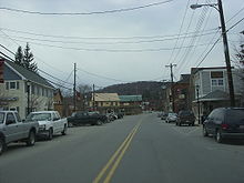 Sullivan CR 149 heading through Livingston Manor
After a short gap in the clearing, Route 149 intersects with Hardenburg Road, a local road, in another clearing. After Hardenburg Road, Shandelee Road begins to bend in different directions, several times to the west and several times to the east, intersecting with Meyer Road at a fork. Route 149, which continues to the left at the fork, heads to the northwest, paralleling Meyer Road to the west. The residences begin to disappear and Route 149 continues into a more wooded area, where it intersects with Whittendale Road, a local dead-end road. A short distance from Whittendale Road, Route 149 makes a sharp bend to the northeast, intersecting with the northern termini of Stump Pond Road and Meyer Road. Near the intersection with Gilda Lane, Route 149 passes the Sand Pond, and intersects with a series of short local roads. Paralleling the shores of Sand Pond for a short distance, Shandelee Road begins to enter the community of Shandelee. There, the highway intersects with Shandelee Lake Road, a short connector highway in the area. Route 149 makes a curve to the east, following Shandelee Road for a distance, making several winds in direction until the alignment turns towards the northeast. Shandelee Road continues to the northeast, passing through local woodlands and fields. As Route 149 nears Livingston Manor, the name changes from Shandelee Road to Main Street.[2]
After a curve to the northeast, Route 149 passes under some power lines, intersecting with Cattall Road. There the highway turns to the north, and soon to the northeast, entering Livingston Manor. Immediately after entering the community, Route 149 becomes more developed, with residential homes and commercial buildings now surrounding highway. After an intersection with Creamery Road, Route 149 continues to the northeast through downtown Livingston Manor, ending at an intersection with CR 178 (a former alignment of NY 17).[1] Interchange 98 on Route 17 (the Quickway), is not far to the north and is accessible via CR 178 and CR 81.[2]
History
 NY 284, CR 149's designation in the 1930s
In the 1930 renumbering of state highways in New York, the New York State Department of Public Works renumbered several routes assigned during the 1920s and assigned route numbers to hundreds of state highways that had yet to receive a designation.[3] By the following year, the current alignment of CR 149, then a state highway, was designated as NY 284.[4] The NY 284 designation was short-lived, however, as it was removed ca. 1939.[5][6] The former alignment of NY 284 was designated as CR 149 by the Sullivan County Highway Department by 1995.[1] The NY 284 designation is now assigned to a road in nearby Orange County.[7]
Major intersections
The entire route is in Sullivan County.
Location Mile[2] Destinations Notes Youngsville 0.00 NY 52Livingston Manor 8.70  CR 178 (Old Route 17)
Former routing of NY 17 1.000 mi = 1.609 km; 1.000 km = 0.621 mi See also
References
- ^ a b c New York State Department of Transportation (1995). Livingston Manor Digital Raster Quadrangle (Map). 1:24,000. http://www.nysgis.state.ny.us/gisdata/quads/drg24/dotpreview/index.cfm?code=y40. Retrieved January 20, 2010.
- ^ a b c d e Yahoo Maps. Overview Map of Sullivan CR 149 (Map). Cartography by NAVTEQ Incorporated. http://maps.yahoo.com/#mvt=m&lat=41.900422&lon=-74.827043&zoom=16&q1=41.805739%2C-74.885408&q2=41.902993%2C-74.82434. Retrieved April 1, 2009.
- ^ Dickinson, Leon A. (January 12, 1930). "New Signs for State Highways". The New York Times: p. 136.
- ^ Kendall Refining Company (1931). New York (Map). Cartography by H.M. Gousha Company.
- ^ Thibodeau, William A. (1938). The ALA Green Book (1938–39 ed.). Automobile Legal Association.
- ^ Standard Oil Company (1939). New York (Map). Cartography by General Drafting.
- ^ New York State Department of Transportation (January 2009) (PDF). Official Description of Highway Touring Routes, Bicycling Touring Routes, Scenic Byways, & Commemorative/Memorial Designations in New York State. https://www.nysdot.gov/divisions/operating/oom/transportation-systems/repository/2009%20tour-bk.pdf. Retrieved July 16, 2009.
External links
Categories:- County routes in Sullivan County, New York


Wikimedia Foundation. 2010.