- New York State Route 284
-
This article is about the current alignment of NY 284. For the former alignment of NY 284 in Sullivan County, see New York State Route 284 (1931–1939).
NYS Route 284 
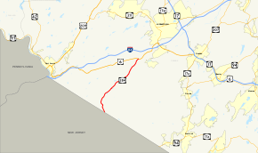
Map of Orange County with NY 284 highlighted in redRoute information Maintained by NYSDOT Length: 9.01 mi[2] (14.50 km) Existed: May 1966[1] – present Major junctions South end:  Route 284 at Minisink
North end:  US 6 in Wawayanda
Location Counties: Orange Highway system Numbered highways in New York
Interstate • U.S. • N.Y. (former) • Reference • County←  NY 283
NY 285  →
→←  I-84
I-84
NY 85  →
→New York State Route 284 (NY 284) is a short state highway located entirely in Orange County in New York, United States. It is the continuation of New Jersey Route 284 northbound from the state line at Minisink (just south of Unionville) to U.S. Route 6 (US 6) in Wawayanda. The route heads through rural parts of Orange County for 9 miles (14 km), intersecting with several local and county routes along the way.
Route 284 was originally designated as part of New York State Route 8 in 1924. It became part of New York State Route 84 when the portion of NY 8 south of Montgomery was renumbered to NY 84 in the 1930 renumbering. When Interstate 84 (I-84) was built nearby in May 1966, the route was partially redesignated as NY 284 to prevent confusion.
Contents
Route description
NY 284 begins at the state line in Minisink, Orange County, as a continuation of New Jersey Route 284. The route heads northwest to the village of Unionville, where it intersects with County Route 36 (CR 36), a route that becomes CR 651 upon entering Sussex County in New Jersey. Outside the village, Route 284 curves to the northeast and proceeds through farmlands, paralleling the Middletown and New Jersey Railway for a short distance.[3]
The local road then passes Lockhurst Pond and intersects with CR 1 in the hamlet of Westtown. Route 284 passes to the southeast of Green Ridge Golf Course as it heads to the northeast. Some local and county routes intersect NY 284 as it heads northeastward into the town of Wawayanda; however, no state-maintained routes do. Route 284 passes Shannen Park on its way to the hamlet of Slate Hill, where it comes to an end at US 6.[3]
Trucks using NY 284 (along with NY 17A and NY 94 between US 6 and the state line) are limited to 10 tons (9 tonnes) gross vehicular weight, to better protect the highways' status as key transport routes between I-84 and northwestern New Jersey.
History
Route 284 was originally designated as part of NY 8 when the first set of posted routes in New York were assigned in 1924. North of Slate Hill, NY 8 continued northeast to Newburgh by way of modern US 6, NY 211 and NY 17K.[4] In the 1930 renumbering, all of NY 8 south of Montgomery was renumbered to NY 84. The portion of NY 8 east of the village became NY 215.[5] When I-84 was built in May 1966, the NY 84 designation was eliminated to prevent confusion between the two nearby roads. The section of Route 84 south of Slate Hill was renumbered to NY 284,[1] while the remainder of the route became part of US 6 (which NY 84 overlapped) and NY 211.[6][7]
Major intersections
The entire route is in Orange County.
Location Mile[2] Destinations Notes Minisink 0.00  Route 284
Continuation into New Jersey Wawayanda 9.01  US 6
US 61.000 mi = 1.609 km; 1.000 km = 0.621 mi References
- ^ a b Sinsabaugh, Mark. "New York State Route 284". New York Routes. http://www.gribblenation.net/nyroutes/ind/280_289.htm#284. Retrieved May 1, 2008.
- ^ a b "2008 Traffic Data Report for New York State" (PDF). New York State Department of Transportation. June 16, 2009. p. 286. https://www.nysdot.gov/divisions/engineering/technical-services/hds-respository/NYSDOT_Traffic_Data_Report_2008.pdf. Retrieved December 9, 2009.
- ^ a b Google, Inc. Google Maps – overview map of NY 284 (Map). Cartography by Google, Inc. http://maps.google.com/maps?hl=en&rlz=1T4ADBF_enUS232US232&q=from:+RT-284+%4041.294010,+-74.556230+to:+RT-284+%4041.390460,+-74.475265&um=1&ie=UTF-8&sa=N&tab=wl. Retrieved February 7, 2008.
- ^ "New York's Main Highways Designated by Numbers". The New York Times: p. XX9. December 21, 1924.
- ^ Automobile Legal Association (ALA) Automobile Green Book, 1930/31 and 1931/32 editions, (Scarborough Motor Guide Co., Boston, 1930 and 1931). The 1930/31 edition shows New York state routes prior to the 1930 renumbering
- ^ State of New York Department of Transportation (January 1, 1970) (PDF). Official Description of Touring Routes in New York State. http://www.greaternyroads.info/pdfs/state70.pdf. Retrieved January 3, 2010.
- ^ Sinclair (1964). New York and Metropolitan New York (Map). Cartography by Rand McNally and Company.
External links
Categories:- State highways in New York
- Transportation in Orange County, New York
Wikimedia Foundation. 2010.


