- New York State Route 391
-
NYS Route 391
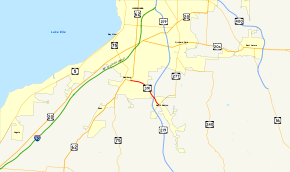
Map of the Buffalo area with NY 391 highlighted in redRoute information Maintained by NYSDOT Length: 3.62 mi[3] (5.83 km) Existed: early 1970s[1][2] – present Major junctions South end:  NY 277 in Boston
 US 219 in Boston
North end:  US 62 in Hamburg
Location Counties: Erie Highway system Numbered highways in New York
Interstate • U.S. • N.Y. (former) • Reference • County←  NY 390A
NY 392  →
→New York State Route 391 (NY 391) is a short state highway in Erie County, New York, United States. The route is signed as north–south; however, it follows more of a southeast–northwest alignment between NY 277 in the hamlet of North Boston and U.S. Route 62 (US 62) in the village of Hamburg. NY 391 meets the Southern Expressway (US 219) just north of North Boston. Both ends of NY 391 are located in residential areas; however, the middle section of the route passes through more rural areas of the towns of Boston and Hamburg.
The routing of NY 391 has been part of several routes over the years, beginning with NY 62 in 1930. NY 62 was mostly renumbered to NY 75 ca. 1932, and all of NY 75 south of Hamburg became concurrent to US 219 when it was extended into New York ca. 1935. NY 75 was cut back to Hamburg by 1940, leaving just US 219 on modern NY 391. US 219 was realigned north of North Boston in the early 1970s to follow other routes north to meet the first completed piece of the Southern Expressway near Orchard Park. NY 391 was assigned to US 219's former routing into Hamburg at this time. The route originally ended two blocks to the west at the junction of NY 75 and US 62; however, this extension was eliminated ca. 2004.
Contents
Route description

NY 391 begins at an intersection with NY 277 (Herman Hill Road) in North Boston, a hamlet within the town of Boston. It heads to the northwest as Boston State Road, passing by suburban homes as it approaches the Southern Expressway (US 219). The two highways meet by way of a diamond interchange. West of the exit, NY 391's surroundings become more rural as it enters the town of Hamburg, where it passes by open fields and a handful of houses.[4]
The route follows Eighteen Mile Creek northwest and west toward the village of Hamburg, where the amount of development along the highway increases significantly. At McKinley Parkway (County Route 204), NY 391 becomes East Main Street and begins to pass through the outskirts of the village. It officially enters Hamburg upon intersecting Sunnyside Drive two blocks to the west. The route continues into the village center, passing by commercial and residential buildings on its way to a roundabout at Buffalo Street, where it meets US 62. At this point, NY 391 comes to an end while US 62 turns west onto Main Street from Buffalo Street.[4]
History
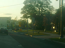 Approaching US 62 on NY 391 northbound in Hamburg
What is now NY 391 was originally designated as part of NY 62, a highway extending from Great Valley north to Buffalo, in the 1930 renumbering of state highways in New York.[5][6] US 62 was extended into New York ca. 1932; as a result, all of NY 62 south of Athol Springs was redesignated as NY 75 to eliminate numerical duplication with the U.S. Highway.[7][8] US 219 was extended into New York ca. 1935, overlapping NY 75 between Great Valley and Hamburg.[9][10] The overlap was eliminated by 1940 following the truncation of NY 75 to what had been the west end of its overlap with US 62 through Hamburg.[11]
In the early 1970s, construction began on the Southern Expressway, a limited-access highway connecting Buffalo to Springville. The first segment of the expressway—between the New York State Thruway east of Lackawanna and US 20A west of Orchard Park—opened to traffic by 1973 as a realignment of US 219. In between the end of the expressway and North Boston, US 219 temporarily overlapped US 20A and NY 277.[2][12] The former routing of US 219 from North Boston to Hamburg was redesignated as NY 391.[1][2]
An extension of the freeway south to NY 391 near North Boston opened in the mid-1970s, resulting in a slight, temporary truncation of NY 391 to the end of the freeway.[13][14] Another extension of the expressway south to Springville was completed in the early 1980s. It became part of US 219 upon opening; at the same time, NY 391 was reextended to NY 277 in North Boston.[15][16] The remainder of remainder of US 219's former routing south to Springville was transferred to Erie County upon the completion of the Springville–Buffalo segment of the Southern Expressway.[17] Originally, NY 391 terminated at NY 75 in Hamburg, resulting in an extraneous overlap with US 62 for two blocks along Main Street. NY 391 was truncated to the eastern end of the concurrency ca. 2004.[18][19]
Major intersections
The entire route is in Erie County.
Location Mile[3] Destinations Notes Boston 0.00 NY 277Hamlet of North Boston; southern terminus of NY 277 0.79 US 219Interchange Village of Hamburg 3.62 US 621.000 mi = 1.609 km; 1.000 km = 0.621 mi References
- ^ a b State of New York Department of Transportation (January 1, 1970) (PDF). Official Description of Touring Routes in New York State. http://www.greaternyroads.info/pdfs/state70.pdf. Retrieved December 16, 2009.
- ^ a b c Shell Oil Company (1973). New York (Map). Cartography by H.M. Gousha Company (1973 ed.).
- ^ a b "2008 Traffic Data Report for New York State" (PDF). New York State Department of Transportation. June 16, 2009. p. 306. https://www.nysdot.gov/divisions/engineering/technical-services/hds-respository/NYSDOT_Traffic_Data_Report_2008.pdf. Retrieved December 9, 2009.
- ^ a b Google, Inc. Google Maps – overview map of NY 391 (Map). Cartography by Google, Inc. http://maps.google.com/maps?sourceid=navclient&ie=UTF-8&rlz=1T4ADBF_enUS232US232&q=from:+Boston+State+Rd/RT-391+%4042.685710,+-78.776680+to:+E+Main+St/RT-391+%4042.715830,+-78.829430&um=1&sa=N&tab=wl. Retrieved March 26, 2008.
- ^ Dickinson, Leon A. (January 12, 1930). "New Signs for State Highways". The New York Times: p. 136.
- ^ Standard Oil Company of New York (1930). Road Map of New York (Map). Cartography by General Drafting.
- ^ Kendall Refining Company (1931). New York (Map). Cartography by H.M. Gousha Company.
- ^ Texas Oil Company (1932). Texaco Road Map – New York (Map). Cartography by Rand McNally and Company.
- ^ Texas Oil Company (1934). Road Map of New York (Map). Cartography by Rand McNally and Company.
- ^ Sun Oil Company (1935). Road Map & Historical Guide – New York (Map). Cartography by Rand McNally and Company.
- ^ Gulf Oil Company (1940). New York Info-Map (Map). Cartography by Rand McNally and Company.
- ^ New York State Thruway Authority (1971). New York Thruway (Map). Cartography by Rand McNally and Company.
- ^ Gulf (1974). New York and New Jersey Tourgide Map (Map). Cartography by Rand McNally and Company.
- ^ Exxon (1977). New York (Map). Cartography by General Drafting (1977–78 ed.).
- ^ State of New York (1981). I Love New York Tourism Map (Map). Cartography by Rand McNally and Company.
- ^ Rand McNally (1985). New York (Map). ISBN 0-528-91040-X.
- ^ New York State Legislature. "New York State Highway Law § 341". http://public.leginfo.state.ny.us/menugetf.cgi?COMMONQUERY=LAWS. Retrieved December 16, 2009.
- ^ "2004 Traffic Data Report for New York State" (PDF). New York State Department of Transportation. p. 253. https://www.nysdot.gov/divisions/engineering/technical-services/hds-respository/NYSDOT_Traffic_Data_Report_2004.pdf. Retrieved December 16, 2009.
- ^ New York State Department of Transportation (October 2004) (PDF). Official Description of Highway Touring Routes, Scenic Byways, & Bicycle Routes in New York State. https://www.nysdot.gov/divisions/operating/oom/transportation-systems/repository/tour_route_0.pdf. Retrieved December 16, 2009.
External links
Categories:- State highways in New York
- Transportation in Erie County, New York


Wikimedia Foundation. 2010.