- New York State Route 281
-
NYS Route 281
Route information Maintained by NYSDOT and the city of Cortland Length: 16.56 mi[3] (26.65 km) Existed: ca. 1931[1][2] – present Major junctions South end:  NY 13 in Cortlandville
 NY 90 in Homer
North end: 
 US 11 / NY 80 near Tully
Location Counties: Cortland, Onondaga Highway system Numbered highways in New York
Interstate • U.S. • N.Y. (former) • Reference • County←  NY 280
NY 282  →
→New York State Route 281 (NY 281) is a north–south state highway in central New York, United States. It extends for 16.56 miles (26.65 km) across Cortland and Onondaga Counties. The southern terminus of the route is at an intersection with NY 13 in the town of Cortlandville. Its northern terminus is at a junction with U.S. Route 11 and NY 80 near the village of Tully. NY 281 meets NY 90 in the village of Homer and connects to Interstate 81 twice. The route parallels I-81 for all but the southernmost 2.5 miles (4.0 km) of its routing.
Contents
Route description
 Southern terminus of NY 281 at NY 13 southwest of Cortland
NY 281 begins at a fork in the road along NY 13 in the town of Cortlandville. While NY 13 continues northeast into downtown Cortland, NY 281 heads northward as West Road, bypassing most of the city to the west. After 1.5 miles (2.4 km), NY 281 intersects NY 222, by which NY 281 connects to Cortland County – Chase Field Airport. The route continues on, briefly passing through the northwestern corner of the city of Cortland before reentering Cortlandville as West Homer Road. Near the northern town line, NY 281 connects to Interstate 81 by way of unsigned NY 930Q.
Now in the village of Homer, NY 281 becomes South West Street as it heads along the western fringe of the community. The route meets NY 90 at Cayuga Street, where it becomes North West Street. Farther north, NY 281 intersects NY 41 at Clinton Street before exiting the village and entering the surrounding town of Homer.
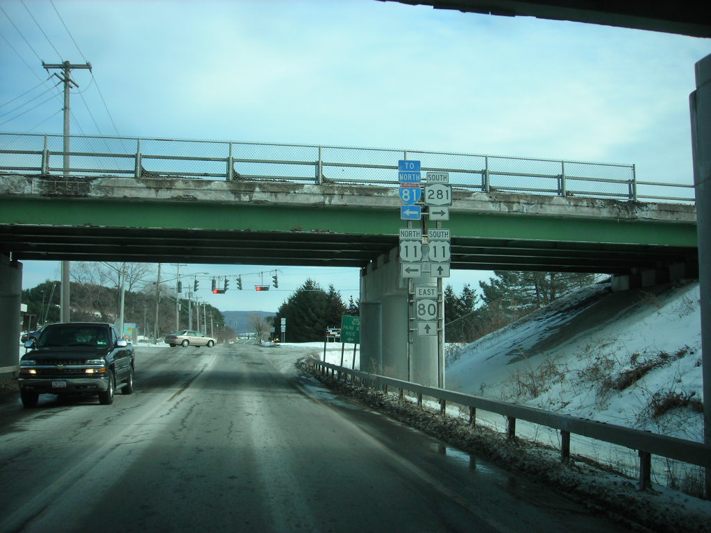
 Northern terminus of NY 281 as seen from NY 80 eastbound
The North West Street name is dropped upon crossing the town line and NY 281 becomes known only by its number. NY 281 parallels I-81 northward through the town of Homer and into the town of Preble, where it meets I-81 a second time as turns to the northeast and crosses over the expressway. North of the junction, NY 281 is flanked by I-81 on its west side and U.S. Route 11 on its east side as all three routes pass into Onondaga County and the town of Tully that lies within. NY 281 continues onward for another 1.5 miles (2.4 km) to a junction with US 11 and NY 80 west of the village of Tully and about 50 yards (46 m) east of where I-81 passes over NY 80. Here, NY 281 terminates and US 11 turns northward to follow the right-of-way of NY 281 toward Syracuse.
History
NY 281 was assigned ca. 1931 to the portion of its alignment between NY 90 in the village of Homer and the hamlet of Preble. In the vicinity of Preble, it initially used modern County Routes 108A and 108B to reach U.S. Route 11.[1][2] The route was extended northward along the western edge of Tully Lake ca. 1933, following Song Lake and Long Roads to a junction with NY 80 west of Tully Center.[4][5] It was extended southward to NY 13 in the town of Cortlandville at some point between 1934 and 1940.[6][7] In the late 1940s, construction began on a new highway between Preble and Tully Center that bypassed Preble and Tully Lake to the east. It was completed by 1949, at which time it became part of a realigned NY 281.[8][9]
Major intersections
County Location Mile[3] Destinations Notes Cortland Cortlandville 0.00 NY 131.61  NY 222
3.80  I-81
I-81Exit 12 (I-81) via unsigned NY 930Q Village of Homer 4.22 NY 904.99  NY 41
NY 41Preble 12.69 I-81Exit 13 (I-81) Onondaga Town of Tully 16.56 US 11 / NY 801.000 mi = 1.609 km; 1.000 km = 0.621 mi References
- ^ a b Standard Oil Company of New York (1930). Road Map of New York (Map). Cartography by General Drafting.
- ^ a b Kendall Refining Company (1931). New York (Map). Cartography by H.M. Gousha Company.
- ^ a b "2008 Traffic Volume Report for New York State" (PDF). New York State Department of Transportation. June 16, 2009. p. 205. https://www.nysdot.gov/divisions/engineering/technical-services/hds-respository/NYSDOT%20TVR%202008%20by%20Route.pdf. Retrieved February 1, 2010.
- ^ Texas Oil Company (1932). Texaco Road Map – New York (Map). Cartography by Rand McNally and Company.
- ^ Texas Oil Company (1933). Texaco Road Map – New York (Map). Cartography by Rand McNally and Company.
- ^ Texas Oil Company (1934). Road Map of New York (Map). Cartography by Rand McNally and Company.
- ^ Gulf Oil Company (1940). New York Info-Map (Map). Cartography by Rand McNally and Company.
- ^ State of New York Department of Public Works. Official Highway Map of New York State (Map). Cartography by General Drafting (1947–48 ed.).
- ^ Esso (1949). New York (Map). Cartography by General Drafting (1950 ed.).
External links
Categories:- State highways in New York
- Transportation in Onondaga County, New York
- Transportation in Cortland County, New York


Wikimedia Foundation. 2010.