- New York State Route 398
-
NYS Route 398
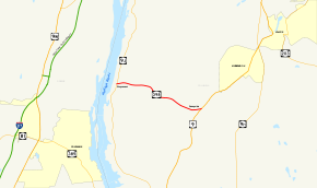
Map of northern Columbia and Greene Counties with NY 398 highlighted in redRoute information Maintained by NYSDOT Length: 3.00 mi[4] (4.83 km) Existed: ca. 1932[1][2] – January 28, 1980[3] Major junctions West end:  NY 9J in Stuyvesant
East end:  US 9 in Stuyvesant
Location Counties: Columbia Highway system Numbered highways in New York
Interstate • U.S. • N.Y. (former) • Reference • County←  NY 397
NY 399  →
→New York State Route 398 (NY 398) was an east–west state highway located within the town of Stuyvesant in Columbia County, New York, United States. It served as a short connector between NY 9J in the hamlet of Stuyvesant and U.S. Route 9 (US 9) in the hamlet of Sunnyside southwest of the village of Kinderhook. NY 398 was assigned in the early 1930s and remained unchanged until 1980, when ownership and maintenance of the highway was transferred to Columbia County. The route was redesignated as County Route 26A at that time.
Contents
Route description
Route 398 began at an intersection with NY 9J in downtown Stuyvesant. The route progressed eastward, passing a small park and intersecting with local roads. Route 398 passed Firwood Barn as it climbed in elevation. The route turned to the southeast and passed some small parks. After that, the route became more rural, climbing even higher in elevation and intersecting with another local road.[5]
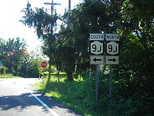 CR 26A at NY 9J in Stuyvesant. The old signage for NY 9J harken back to state-maintenance
After the local road however, the highway began to patch its way through several hills and mountains, but this did not last long. The highway then became rural again, emerging from the mountains behind it. There were a few short hills the rest of the way along Route 398, until it entered the small hamlet of Sunnyside. There, it became a little more suburbanized, and the highway terminated at an intersection with US 9.[6]
History
NY 398 was assigned ca. 1932 to the highway connecting the hamlets of Stuyvesant and Sunnyside.[1][2] It remained unchanged until January 28, 1980, when the NY 398 designation was officially removed from the highway.[3] Ownership and maintenance of NY 398's former routing was transferred from the state of New York to Columbia County on April 1, 1980, as part of a highway maintenance swap between the two levels of government.[7] The highway became part of County Route 26A (CR 26A), a designation that continues west of NY 9J to a junction with River View Street near the Hudson River.[8][9]
Major intersections
The entire route was in Stuyvesant, Columbia County.
Mile[4] Destinations Notes 0.00 NY 9JHamlet of Stuyvesant 3.00 US 9Hamlet of Sunnyside 1.000 mi = 1.609 km; 1.000 km = 0.621 mi See also
- New York State Route 217 – the other route affected by the 1980 Columbia County maintenance swap
References
- ^ a b Kendall Refining Company (1931). New York (Map). Cartography by H.M. Gousha Company.
- ^ a b Texas Oil Company (1932). Texaco Road Map – New York (Map). Cartography by Rand McNally and Company.
- ^ a b New York State Department of Transportation (January 2009) (PDF). Official Description of Highway Touring Routes, Bicycling Touring Routes, Scenic Byways, & Commemorative/Memorial Designations in New York State. https://www.nysdot.gov/divisions/operating/oom/transportation-systems/repository/2009%20tour-bk.pdf. Retrieved July 20, 2009.
- ^ a b Yahoo! Inc. Yahoo! Maps – overview map of former NY 398 (Map). Cartography by NAVTEQ. http://maps.yahoo.com/#mvt=m&lat=42.390676&lon=-73.779843&zoom=16&q1=42.377853%2C-73.727959&q2=42.390089%2C-73.780916. Retrieved June 29, 2008.
- ^ United States Geological Survey (1980). Ravena, NY quadrangle (Map). http://www.nysgis.state.ny.us/gisdata/quads/drg24/usgspreview/index.cfm?code=o42073d7. Retrieved June 29, 2008.
- ^ United States Geological Survey (1980). Kinderhook, NY quadrangle (Map). http://www.nysgis.state.ny.us/gisdata/quads/drg24/usgspreview/index.cfm?code=o42073d6. Retrieved June 29, 2008.
- ^ New York State Legislature. "New York State Highway Law § 341". http://public.leginfo.state.ny.us/menugetf.cgi?COMMONQUERY=LAWS. Retrieved July 20, 2009.
- ^ New York State Department of Transportation (1993). Ravena Digital Raster Quadrangle (Map). 1:24,000. http://www.nysgis.state.ny.us/gisdata/quads/drg24/dotpreview/index.cfm?code=u48. Retrieved July 20, 2009.
- ^ New York State Department of Transportation (1995). Kinderhook Digital Raster Quadrangle (Map). 1:24,000. http://www.nysgis.state.ny.us/gisdata/quads/drg24/dotpreview/index.cfm?code=u49. Retrieved July 20, 2009.
External links
Categories:- Former state highways in New York
- Transportation in Columbia County, New York


Wikimedia Foundation. 2010.