- List of county routes in Chautauqua County, New York
-
The following is a list of county routes in Chautauqua County, New York. All county routes in Chautauqua County are signed with the standard blue pentagonal shield. Even numbered routes are west–east roads, while odd numbered routes are south–north roads. The numbers increase roughly from southwest to northeast across the county.
Routes
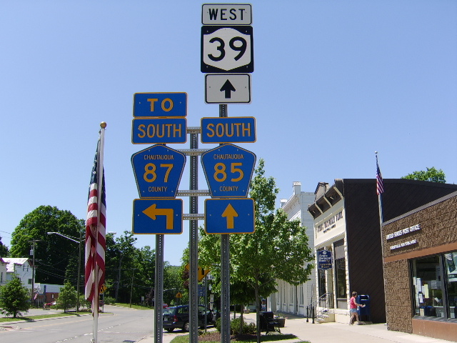
 This signpost in Forestville, New York shows County Route 85 running concurrently with New York State Route 39. A junction with County Route 87 lies ahead.
# Road Name(s) Direction and Termini Note(s) CR 1 Mann Road N/S NY 426 west of French Creek NY 426/NY 430 in Mina CR 2 North Road W/E NY 426 north of Cutting CR 15 north of Clymer CR 3 North Road N/S NY 426/NY 430 in Findley Lake New York-Pennsylvania border near Ripley continues as PA QR 1012 CR 4 W/E NY 426 west of French Creek NY 76 in Sherman CR 6 W/E New York-Pennsylvania border near Ripley NY 76 at Sheldon Corners continues as PA QR 1010 CR 7 N/S CR 4 north of French Creek NY 430 in Mina CR 8 Nazareth Road W/E NY 474 east of Clymer CR 23 in Clymer CR 9 N/S CR 6 in Ripley NY 76 in Wattlesburg CR 10 W/E CR 15 in Clymer NY 474 in Panama CR 11 Marks Corners Road N/S CR 4 north of Marks Corners NY 430 west of Sherman CR 12 Kortwright Road W/E CR 33 west of Niobe CR 69 in Busti CR 13 N/S NY 430 east of Mina CR 6 at Sheldon Corners CR 14 Button Valley Road W/E CR 33 in Panama CR 35 north of Watts Flats CR 15 N/S New York-Pennsylvania border south of Clymer NY 76/NY 430 in Sherman continues as PA QR 2027 CR 16 W/E CR 33 in North Harmony Stow Road in North Harmony CR 18 W/E NY 76 in Sherman NY 394 south of Magnolia CR 19 Clymer Hill Road N/S NY 474 east of Clymer CR 15 in Sherman CR 21 Sherman Road
Chestnut StreetN/S NY 76 at Nettle Hill Corners US 20 in Westfield CR 22 Nettle Hill Road W/E NY 76 at Nettle Hill Corners NY 430 in Summerdale CR 23 Town Line Road N/S New York-Pennsylvania border near Clymer NY 474 west of Panama continues as PA QR 4004 CR 25 Hawley Street W/E NY 5 west of Barcelona NY 394 in Westfield CR 25 Morris Road
Morris StreetN/S CR 18 at Stebbins Corners NY 394 in Mayville CR 26 Donelson Road
Wait RoadW/E NY 952P/CR 28/CR 45 in Busti CR 49 in Kiantone CR 27 Honeysette Road N/S NY 430 in Mayville CR 29 north of Hartfield CR 28 W/E NY 952P/CR 26/CR 45 in Busti NY 60/CR 380 in Stillwater CR 29 Plank Road
Academy StreetN/S NY 430 in Hartfield US 20 in Westfield CR 30 Baker Street
Newland AvenueW/E NY 474 west of Ashville NY 952P in Jamestown CR 31 Felton Road N/S CR 29 east of Westfield US 20 east of Westfield CR 32 Hunt Road W/E CR 43 south of Ashville Jamestown city line CR 33 N/S New York-Pennsylvania border near Harmony NY 394 in Chautauqua continues as PA 958 CR 34 W/E US 62/CR 55 in Frewsburg Cattaraugus County line continues as Cattaraugus CR 89 CR 35 N/S CR 12 in Cherry Hill CR 33 in Elm Tree CR 36 W/E US 62 west of Ivory Cattaraugus County line continues as Cattaraugus CR 33 CR 37 Beech Hill Road
Frances RoadN/S CR 58 east of Hartfield CR 380 in Stockton CR 38 Willard Street W/E Jamestown city line CR 380 east of Jamestown CR 40 Buffalo Street W/E NY 394 in Jamestown CR 380 east of Jamestown CR 42 W/E NY 394 in Poland Center Cattaraugus County line continues as Cattaraugus CR 8 CR 43 N/S CR 30 in Boomertown NY 394 north of Ashville CR 44 Salisbury Road W/E NY 430/NY 954J in Bemus Point CR 380 in Kimball Stand CR 45 Southwestern Drive N/S NY 952P/CR 26/CR 28 in Busti NY 394 in Lakewood CR 46 Hayner Road W/E NY 430 in Maple Springs CR 44 in Ellery Center CR 47 South Main Street Extension
South Main StreetN/S CR 28 south of Jamestown NY 60 in Jamestown CR 48 Towerville Road W/E CR 44 in Ellery Center CR 59 in Towerville CR 49 N/S US 62 south of Kiantone NY 60 in Stillwater CR 50 Gerry-Ellington Road W/E NY 60 in Gerry US 62/CR 66 in Ellington CR 51 Martin Road N/S NY 60 east of Stillwater Jamestown city line CR 52 W/E NY 430 in Dewittville CR 66/CR 380 in Redbird CR 53 N/S New York-Pennsylvania border near Frewsburg US 62 in Frewsburg Old US 62; continues as PA QR 1015 CR 54 Centralia Hartfield Rd. W/E NY 430 west of Hartfield CR 57/CR 380 in Centralia CR 55 N/S US 62/CR 34 in Frewsburg CR 380 south of Falconer CR 56 W/E CR 71/CR 380 in South Stockton CR 66 south of Sinclairville CR 57 Dutch Hollow Road N/S NY 430 in Greenhurst CR 54/CR 380 in Centralia CR 58 Stockton Road W/E NY 430 south of Hartfield NY 60 in Cassadaga partially old NY 424 CR 59 Town Line Road N/S NY 430 in Fluvanna CR 380 in Towerville Runs along eastern town line of Ellery CR 61 West Oak Hill Road N/S NY 60 in Jamestown CR 59 in Ellicott CR 63 N/S CR 380 in Ross Mills CR 65 in Ellicott CR 64 Bates Road W/E CR 66/CR 77 in Sinclairville CR 66 in Bates CR 65 Elmwood Avenue N/S Carlton Avenue in Falconer NY 60/CR 50 in Gerry CR 66 W/E CR 52/CR 380 at Redbird US 62/CR 50 in Ellington runs concurrent with CR 77 in Sinclairville CR 67 Waterford Hill Road
Watkins Road
Bush RoadN/S NY 394 in Waterboro US 62 in Clear Creek Bush Road, which runs along Cattaraugus County border, also designated Cattaraugus CR 64 CR 68 W/E NY 83 in Cherry Creek CR 85 west of Cherry Creek CR 69 Big Tree Road N/S New York-Pennsylvania border near Busti NY 394 west of Lakewood continues as PA 69 CR 70 W/E NY 83 in Cherry Creek Cattaraugus County line continues as Cattaraugus CR 6 CR 71 N/S CR 56/CR 380 in South Stockton CR 58 in Cassadaga CR 72 Bard Road W/E NY 60 in Cassadaga NY 83 in Hamlet CR 73 Water Street N/S CR 380 north of Stockton US 20 in Fredonia CR 74 Berry Road
Berry Street
Chestnut StreetW/E NY 5 in Greencrest US 20 in Fredonia CR 75 Barnum Road N/S CR 66/CR 77 in Sinclairville NY 60 south of Cassadaga CR 77 Center Road
Rood RoadN/S NY 60 south of Sinclairville CR 72 in Arkwright runs concurrent with CR 66 in Sinclairville CR 78 Van Buren Road
Matteson StreetW/E NY 5 in Van Buren Point County Highways 98B & 113 in Fredonia CR 79 Center Road N/S CR 72 in Griswold NY 5 in Sheridan CR 80 New Road W/E Dunkirk city line US 20 east of Dunkirk CR 81 Whitaker Road
Roberts RoadN/S CR 79 in Sheridan NY 5 in Dunkirk partially old NY 39 CR 82 Middle Road W/E NY 5 in Dunkirk CR 79 north of Sheridan CR 84 King Road W/E US 20 west of Sheridan CR 85 at Keaches Corners CR 85 Division Street
Burgess StreetN/S CR 66 in Thornton US 20 in Silver Creek partially old NY 428
runs concurrent with NY 83 in Arkwright
runs concurrent with NY 39 in ForestvilleCR 86 Stebbins Road W/E US 20 south of Silver Creek CR 89 south of Hanover Center CR 87 Prospect Road N/S NY 83/NY 322 at Balcom Corners NY 39 in Forestville CR 88 Versailles Road W/E CR 93 north of Smith Mills Cattaraugus County line continues as Cattaraugus CR 42 CR 89 Dennison Road
Angell RoadN/S CR 85 in Forestville CR 95 north of Hanover Center CR 91 N/S CR 87 north of Balcom Corners CR 93 in Villenova CR 93 Hanover Road
Hanover StreetN/S NY 322 west of South Dayton US 20 in Silver Creek Starts as Hanover St. in Silver Creek becoming Hanover Rd. at the bend as you head south from US 20, This stretch of CR 93 until the village line is 30 MPH; Once CR 93 crosses into the Town of Hanover itself it speeds up to 40 MPH then eventually 55 MPH just north of the NY State Thruway bridge. This speed limit stays until about one half mile north of the Hamlet of Smith Mills where it goes back down to 40 MPH as a speed zone. About a mile or so after you pass thru Smith Mills it resumes the State Speed Limit of 55 MPH until its southern terminus with NY 322 in the Town of Villenova. CR 93 does intersect with NY 39 about 7 to 8 miles south of Silver Creek. CR 95 Allegany Road N/S CR 93 in Hanover US 20/NY 5 west of Irving CR 380 Peck Settlement Road
Work StreetW/E CR 28 in Stillwater US 20 in Brocton Part is former NY 380 See also
External links
Categories:- County routes in Chautauqua County, New York
Wikimedia Foundation. 2010.