- New York State Route 252A
-
NYS Route 252A

Map of southwestern Rochester with NY 252A highlighted in redRoute information Auxiliary route of NY 252 Maintained by Monroe County Length: 4.40 mi[3] (7.08 km) Existed: late 1950s[1][2] – present Major junctions West end: 
 NY 33A / NY 386 in Chili
East end:  NY 383 in Chili
Location Counties: Monroe Highway system Numbered highways in New York
Interstate • U.S. • N.Y. (former) • Reference • County←  NY 252
NY 253  →
→New York State Route 252A (NY 252A) is an east–west state highway located within the town of Chili in Monroe County, New York, in the United States. The western terminus of the route is at an intersection with NY 33A and NY 386 in the hamlet of Chili Center. Its eastern terminus is at a junction with NY 383 near the Greater Rochester International Airport. NY 252A is known as Paul Road and is an alternate route of NY 252 through Chili; however, it does not directly connect to NY 252.
NY 252A was originally designated as New York State Route 198 ca. 1932. NY 198 became part of NY 252 in the late 1940s; however, NY 252 was realigned in the late 1950s to follow a more southerly alignment through the town of Chili. Its former routing was then redesignated as NY 252A. The route was realigned slightly in the late 1960s following an expansion of the Greater Rochester International Airport's primary runway. Ownership and maintenance of NY 252A was transferred from the state of New York to Monroe County as part of a highway maintenance swap that took effect on November 26, 2007.
Contents
Route description
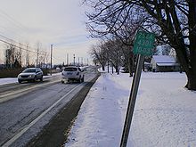
 2000 photo of the first reassurance marker on NY 252A westbound
NY 252A begins at an intersection with NY 33A and NY 386 in Chili Center, a hamlet located within the town of Chili. The route heads eastward from the commercial community and passes through largely residential neighborhoods on its way across Chili. As it approaches the Greater Rochester International Airport, the homes are gradually replaced by industrial factories and warehouses. It crosses the Rochester and Southern Railroad in the community of Maplewood just before intersecting Beahan Road, a local road that serves as the western extent of the airport property.[4]
The route, and Paul Road along with it, turns southward at the Beahan Road junction, replacing Beahan Road as the boundary-delimiting highway. This portion of NY 252A forms a "U" as it loops around the southern end of the airport's primary runway. East of the runway, the route gradually curves to the northeast before ending south of the airport at a junction with NY 383 2 miles (3.2 km) southwest of the city of Rochester.[4]
History
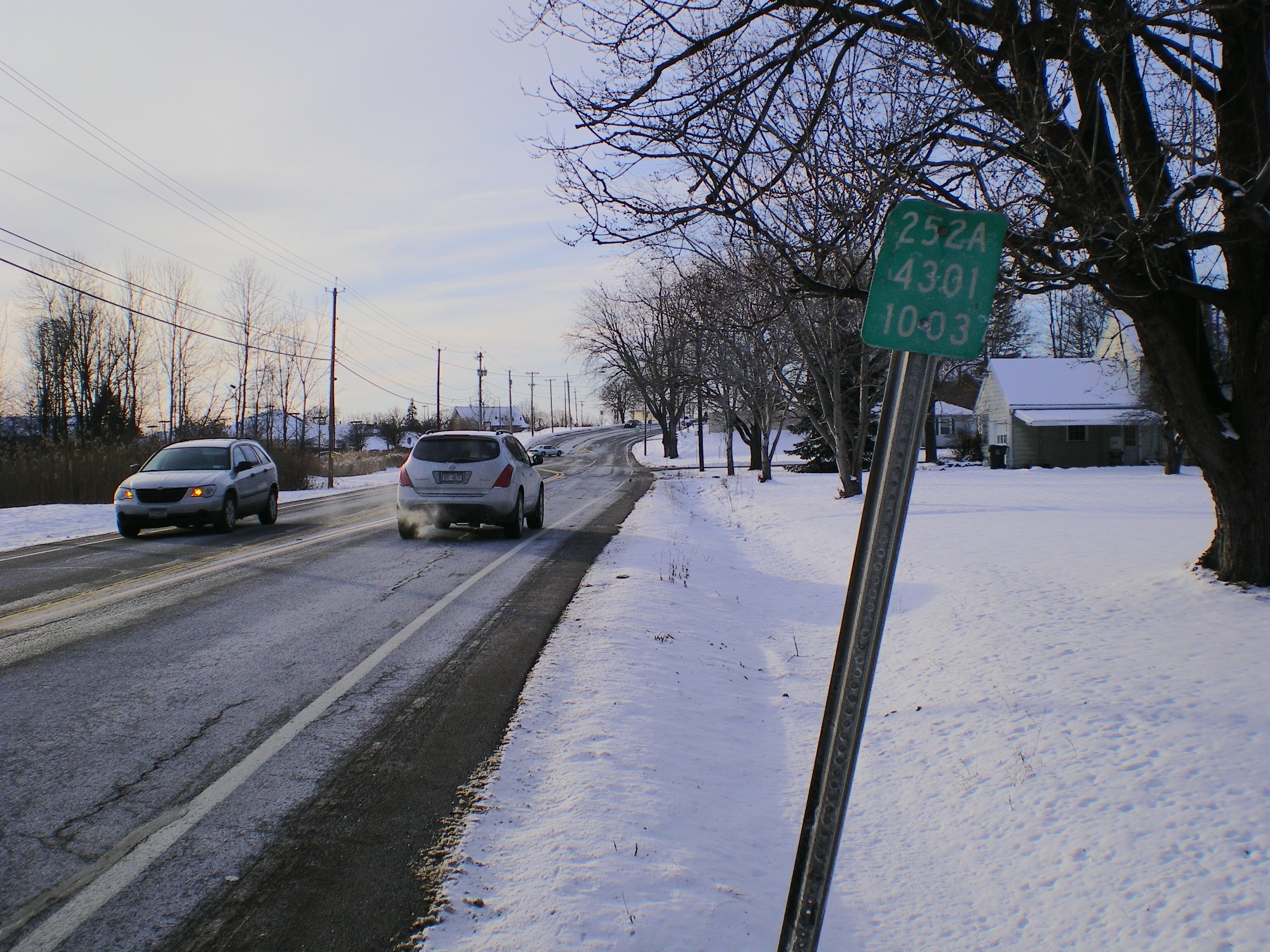
 A reference marker on NY 252A westbound near NY 33A and NY 386
The east–west highway connecting the hamlet of Chili Center to the western bank of the Genesee River by way of the community of Maplewood was originally known as Clifton Road. At the time, Clifton Road continued due east from the modern junction of Paul and Beahan Roads to Scottsville Road (now NY 383).[5] It became a state highway on August 6, 1903, following the conclusion of a 13-month project to improve the highway.[6] The Chili Center – Maplewood highway was designated as NY 198 ca. 1932.[7][8]
NY 198 became a westward extension of NY 252 in the late 1940s,[9][10] and Clifton Road was renamed to Paul Road in the early 1950s.[11][12] NY 252 was rerouted in the late 1950s to follow a new, more southerly alignment through Chili. The former routing of NY 252 between Chili Center and NY 383 was then redesignated as NY 252A even though it did not directly connect to NY 252, its implied parent route.[1][2] In the late 1960s, the then-Rochester – Monroe County Airport expanded its primary runway southward across a tract of land that included part of NY 252A's routing. As a result, NY 252A was moved onto a new alignment that circumvented the runway to the south.[13][14]
In 2007, ownership and maintenance of NY 252A was transferred from the state of New York to Monroe County as part of a highway maintenance swap between the two levels of government. A bill (S4856, 2007) to enact the swap was introduced in the New York State Senate on April 23 and passed by both the Senate and the New York State Assembly on June 20. The act was signed into law by Governor Eliot Spitzer on August 28. Under the terms of the act, it took effect 90 days after it was signed into law; thus, the maintenance swap officially took place on November 26, 2007.[15] NY 252A is now overlapped with CR 168,[16] which was extended eastward from its previous terminus at NY 33A and NY 386 in Chili Center to cover NY 252A.[17]
Major intersections
The entire route is in Chili, Monroe County.
Mile[3] Destinations Notes 0.00 NY 33A / NY 386Hamlet of Chili Center 4.40 NY 3831.000 mi = 1.609 km; 1.000 km = 0.621 mi References
- ^ a b Esso (1956). New York with Special Maps of Putnam–Rockland–Westchester Counties and Finger Lakes Region (Map). Cartography by General Drafting (1957 ed.).
- ^ a b Esso (1958). New York with Special Maps of Putnam–Rockland–Westchester Counties and Finger Lakes Region (Map). Cartography by General Drafting (1958 ed.).
- ^ a b "2008 Traffic Data Report for New York State" (PDF). New York State Department of Transportation. June 16, 2009. p. 278. https://www.nysdot.gov/divisions/engineering/technical-services/hds-respository/NYSDOT_Traffic_Data_Report_2008.pdf. Retrieved August 5, 2009.
- ^ a b Yahoo! Inc. Yahoo! Maps – overview map of NY 252A (Map). Cartography by NAVTEQ. http://maps.yahoo.com/#mvt=h&lat=43.10449&lon=-77.70982&zoom=15&q1=43.107705%2C-77.744993&q2=43.109115%2C-77.674601. Retrieved August 5, 2009.
- ^ Esso (1938). New York Road Map for 1938 (Map). Cartography by General Drafting.
- ^ New York State Department of Highways (1920). Report of the State Commissioner of Highways. Albany, New York: J. B. Lyon Company. p. 210. http://books.google.com/books?id=Sj4CAAAAYAAJ&pg=PA210. Retrieved August 5, 2009.
- ^ Kendall Refining Company (1931). New York (Map). Cartography by H.M. Gousha Company.
- ^ Texas Oil Company (1932). Texaco Road Map – New York (Map). Cartography by Rand McNally and Company.
- ^ State of New York Department of Public Works. Official Highway Map of New York State (Map). Cartography by General Drafting (1947–48 ed.).
- ^ Esso (1949). New York (Map). Cartography by General Drafting (1950 ed.).
- ^ Sunoco (1952). New York (Map). Cartography by Rand McNally and Company.
- ^ Esso (1954). New York with Special Maps of Putnam–Rockland–Westchester Counties and Finger Lakes Region (Map). Cartography by General Drafting (1955–56 ed.).
- ^ Esso (1968). New York (Map). Cartography by General Drafting (1969–70 ed.).
- ^ United States Geological Survey (1978). West Henrietta Quadrangle – New York – Monroe Co. (Map). 1:24,000. 7.5 Minute Series (Topographic). http://www.nysgis.state.ny.us/gisdata/quads/drg24/usgspreview/index.cfm?code=o43077a6. Retrieved April 14, 2009.
- ^ New York State Legislature. "Bills of New York State – bill number-based search". http://public.leginfo.state.ny.us/menugetf.cgi. Retrieved February 5, 2010.
- ^ Monroe County, New York. "Monroe County Map Builder". http://www.mappingmonroe.org/mmb/. Retrieved March 23, 2009. The dates and designations were obtained by using the Identify tool.
- ^ New York State Department of Transportation (1997). West Henrietta Digital Raster Quadrangle (Map). 1:24,000. http://www.nysgis.state.ny.us/gisdata/quads/drg24/dotpreview/index.cfm?code=p17. Retrieved August 5, 2009.
External links
Categories:- State highways in New York
- Transportation in Monroe County, New York


Wikimedia Foundation. 2010.