- Genesee River
Geobox River
name = Genesee River
native_name =
other_name =
other_name1 =
image_size = 300
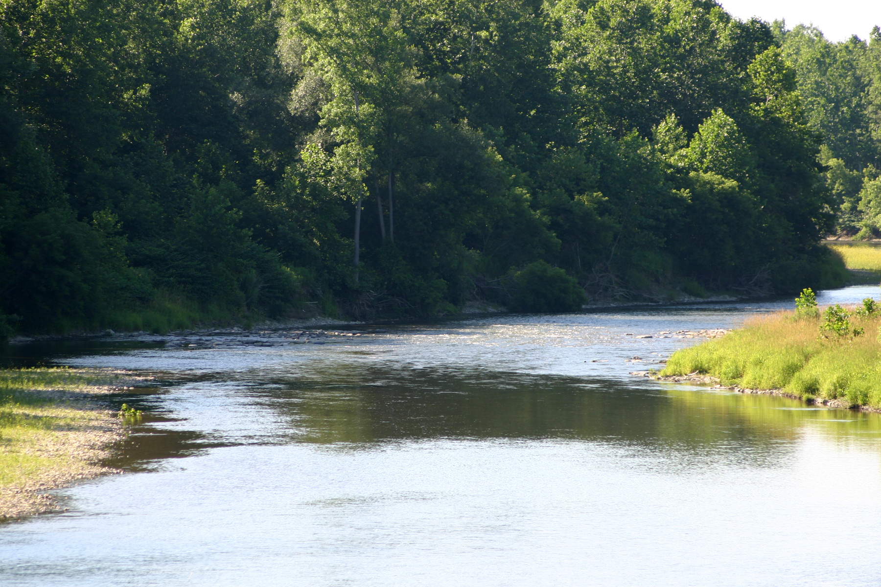
image_caption = Upper Genesee near Belmont
country =USA
country1 =
state =New York
state1 =Pennsylvania
region_type = Counties
region = Monroe, NY
region1 = Livingston, NY
region2 = Wyoming, NY
region3 = Allegany, NY
region4 = Potter, PA
district =
district1 =
city = Rochester, NY
city1 = Wellsville, NY
city2 = Genesee, PA
city3 = Geneseo, NY
length_imperial = 157
watershed_imperial = 2500
discharge_location = Rochester
discharge_average_imperial = 4430
discharge_max_imperial =
discharge_min_imperial =
discharge1_location = Portageville, NY
discharge1_average_imperial = 2720
source_name =
source_location = Ulysses Township
source_district =
source_region = Potter County
source_state =Pennsylvania
source_country =USA
source_lat_d = 41
source_lat_m = 54
source_lat_s = 12
source_lat_NS = N
source_long_d = 77
source_long_m = 43
source_long_s = 58
source_long_EW = W
source_elevation_imperial = 2240
source_length_imperial =
mouth_name =Lake Ontario
mouth_location = Rochester
mouth_district =
mouth_region = Monroe County
mouth_state =New York
mouth_country =USA
mouth_lat_d = 43
mouth_lat_m = 15
mouth_lat_s = 31
mouth_lat_NS = N
mouth_long_d = 77
mouth_long_m = 36
mouth_long_s = 10
mouth_long_EW = W
mouth_elevation_imperial = 256
tributary_left = Oatka Creek
tributary_left1 =
tributary_right = Canaseraga Creek
tributary_right1 =
free_name =
free_value =
map_size = 300
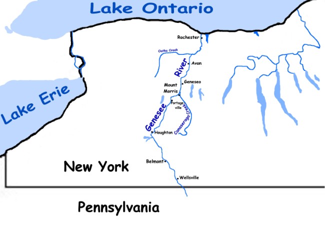
map_caption = Map of Genesee River The Genesee River's (Čunehstí•yu• [Rudes, B. "Tuscarora English Dictionary" Toronto: University of Toronto Press, 1999] in Tuscarora) name is derived from theSeneca tribe word meaning "good valley" or "pleasant valley". It flows northward through westernNew York from its source south of the town of Genesee inPennsylvania , nearWellsville (village), New York and empties intoLake Ontario north of the City of Rochester, New York. The river drains about 2500 square miles (6,500 km²). Falls along the river are within the gorge ofLetchworth State Park (the Grand Canyon of the East) nearPortageville, New York and within Rochester, where they provided power to 19th century industry. A dam at Mount Morris is the largest flood control dam east of the Mississippi. It has greatly reduced flood damage in the lower Genesee Valley; its capacity has never been exceeded. The dam was completed in 1952.The river was the original source of power and commerce in the Rochester area. Many grist mills along the river grind more flour than anywhere else in North America, giving Rochester her nickname "Flour City".
Geology
The present river valley has been modified extensively from preglacial river valleys. The original river had two branches. The east branch has a larger preglacial valley. It runs south of Mount Morris. It was completely blocked by extensive terminal
moraine s just south of Dansville, so most of the upper section was diverted toward theSusquehanna River system. Now only a small creek flows in what is left of this large valley. The west branch, which was smaller, is now the Genesee River above Mount Morris.
[
Letchworth State Park ] The present river is the western branch of the preglacial system. Along its entire course, the rock layers are tilted to the south an average of forty feet per mile, so the river flows across progressively older bedrock as it flows northward. It rises in the highlands of theAllegheny Plateau in conglomerate,sandstone andshale rocks ofMississippian andPennsylvanian age, passing through and often exposing older rocks as it drops. At Letchworth it exposesshale s (some rich in hydrocarbons),siltstone s and somelimestone s ofDevonian age. At Rochester it again cuts a canyon with three more waterfalls in limestones and shales ofSilurian age. The river is a highly favored area forfossil collectors, as one can find a great variety from a very long time span, within the short course of the river.The river empties into
Lake Ontario at Charlotte, a neighborhood of the City ofRochester, New York .History
The Genesee River Valley westward to
Lake Erie and theNiagara River was the homeland of the Seneca Nation of theIroquois Confederacy, also known as "The Keepers of the Western Door", as they were the westernmost nation. The Senecas were gradually divested of their homelands and now have just three small reservations left.The falls at present day Rochester were likely the main reason for the city's existence, as they provided water power for mills. cite journal |last=Baily |first=Rod |year=1984 |month=July and October|title=Sources of Energy in Rochester's History|journal=Rochester History |volume=XLVI |issue=3-4 | publisher=Rochester Public Library | issn =0035-7413 |url=http://www.rochester.lib.ny.us/~rochhist/v46_1984/v46i3-4.pdf |accessdate=2007-12-29 ] When the
Erie Canal was completed in 1825 the mills could ship their products cheaply toNew York City , and business boomed. Rochester became known as the "Flour City".The Erie Canal crossed the Genesee River by a stone aqueduct a few hundred feet north of the center of the then Village of Rochester. The original aqueduct was completed in September 1823 and was 802 feet long and 17 feet wide. The aqueduct was rebuilt between 1836 and 1842. This enlarged aqueduct was 848 feet long and 45 feet wide. The 1842 aqueduct can be seen today as the lower level of the Broad Street (Rochester) bridge across the Genesee River. The erie canal was rerouted south of Rochester in 1917 and now flows across the river at grade in Rochester's
Genesee Valley Park .Most of New York west of the Genesee River was part of
the Holland Purchase after theAmerican Revolution . From 1801 to 1846 the entire region was sold to individual owners from the Holland Land office inBatavia, New York . Today the region derives its name from the river and is generally referred to asGenesee Country . To the east of the river is theFinger Lakes geographic region.Following the spectacular success of the
Erie Canal , completed in 1825, a group of investors dreamed of connecting the Erie Canal to theMississippi River System by building a new canal from the Erie, near Rochester, up the Genesee Valley, across to the Allegany River at Olean, thence downward to theOhio and Mississippi valleys. Construction of theGenesee Valley Canal was begun in 1836, and new sections extended upriver, southward until 1880. During that time the canal was an important commercial route for the valley. The canal was plagued by frequent flood damage and the final leg down the Allegany River was never completed.The most difficult section to build was the bypass around the gorge and falls at present day Letchworth Park. The canal followed the old Native American
portage route, which necessitated many locks. These old locks can still be seen near Nunda. The project was abandoned and the right of way was sold in 1880. The property became the roadbed for theGenesee Valley Canal Railroad , which eventually merged with thePennsylvania Railroad . Much of the canal and railroad right-of-way is open to the public today as theGenesee Valley Greenway .On Friday, November 13, 1829 (Friday the 13th),
Sam Patch , the daredevil, jumped to his death before 8,000 spectators at the Upper Falls of the Genesee in Rochester.In 1865, a sudden march thaw flooded Downtown Rochester, the worst flood in the City's history. After a flood in 1913 that was almost as severe, the rock bed of the Genesee River in Downtown Rochester was cut to make the river channel deeper.
In 1852 a wooden railroad bridge was built over the Upper Falls at Portageville. It was the largest of all wooden bridges built at the time. The wood from 300 acres (1.2 km²) of trees was required for its timber.
The "great flood of 1972", spawned from the remnants of
Hurricane Agnes , wreaked devastation upon the county with the most concentrated damage occurring at and near the Village of Wellsville. Wellsville is the largest village inAllegany County, New York , which contains no cities, and is the junction of many foothill streams including Dyke Creek feeding the Genesee River from the east and Andover. Since Dyke Creek had also exceeded its bank capacity, it aided in producing a rapid and huge pool of water at the center of the Village of Wellsville. The damage area continued downstream through Scio and Amity until the valley widened to accept the large flow of water in the lesser populated area. Erosion of topsoil during this flood reduced the agricultural capacity of the county with serious consequence which eliminated many small farmers immediately.List of communities on the Genesee River
The following communities are on the Genesee River in New York, listed (top to bottom) from its mouth in the north to its source in the south.
The river then crosses the border into
*Town of Irondequoit
*City of Rochester
*Town of Gates
*Town of Brighton
*Town of Chili
*Town of Henrietta
*Town of Wheatland
*Town of Rush
*Town of Caledonia
*Town of Avon
*Town of York
*Town of Geneseo
*Village of Geneseo
*Town of Leicester
*Town of Mount Morris
*Town of Castile
*Town of Portage
*Town of Genesee Falls
* Hamlet of Portageville
*Town of Hume
*Town of Granger
*Town of Caneadea
*Town of Belfast
*Town of Angelica
*Town of Amity
*Town of Scio
*Town of Wellsville
*Town of Willing
*Town of WhitesvillePennsylvania .ee also
*
List of New York rivers
*List of Pennsylvania rivers External links
* [http://nysparks.state.ny.us/parks/info.asp?parkID=12 Letchworth State Park]
* [http://www.lrb.usace.army.mil/WhoWeAre/MMD/MMD.html Mount Morris Dam]
* [http://www.fogvg.org The Genesee Valley Greenway]References
For further reading
"A River Ramble"
Arch Merrill , 1943 - The "Poet Laureate of the Genesee Country" walked the entire length of the Genesee River, weaving a book about the valley's history and his experiences. Merrill was also a journalist at theDemocrat and Chronicle in Rochester.
Wikimedia Foundation. 2010.