- Washington State Route 530
Infobox WA State Route
type=State
route=530
parent_type=Interstate
parent=5
sec=755
length_mi=50.52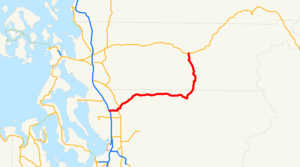
length_ref=cite web|author=Washington State Department of Transportation |url=http://www.wsdot.wa.gov/mapsdata/tdo/PDF_and_ZIP_Files/HwyLog2006.pdf|title=State Highway Log, 2006|accessdate=2007-04-22]
length_round=2
dir1=West
dir2=East
from=
junction=
to=
previous_type=WA
previous_route=529
next_type=WA
next_route=531State Route 530 is a state highway in the
U.S. state ofWashington . The route runs from Interstate 5 near Arlington and goes east to SR 20 in Rockport. The route was created in 1964 and since has been shortened and expanded to its current alignment. It extends from Snohomish County to Skagit County.Route description
SR 530 starts at Interstate 5 near Arlington and goes east to SR 9 in Arlington, where it has a short concurrency. Then, the highway continues east to Darrington and north to SR 20 in Rockport. [cite web |url=http://maps.google.com/?ie=UTF8&ll=48.238852,-121.963348&spn=0.130337,0.535583&z=11 |title=SR 530 Map- I-5 to White Horse |author=
Google Maps |accessdate=2008-06-14] [cite web |url=http://maps.google.com/?ie=UTF8&ll=48.366286,-121.420898&spn=0.260023,1.071167&z=10 |title=SR 530 Map- Darrington to SR 20 |author=Google Maps |accessdate=2008-06-14]History
SR 530 was first created in 1937 as SSH 1E. [cite web |url=http://www.angelfire.com/wa2/hwysofwastate/ssh001e.html |title=SSH 1E |author=Highways of Washington |accessdate=2008-06-14] SSH 1E was given the SR 530 designation in 1964. SR 530 ran from I-5 in Conway south to Stanwood, where it intersected with SR 532, and went southeast along the Pioneer Highway to its current ending at I-5. Then, SR 530 went on its current route up to Darrington, where it ended.
In the 1980's, SR 530 was extended to SR 20 in Rockport and in
1992 , the route from Conway to I-5 near Arlington was dropped from the system. [cite web |url=http://www.angelfire.com/wa2/hwysofwastate/sr530.html |title=State Route 530 |author=Highways of Washington |accessdate=2008-06-14] The route from Conway toSmokey Point Boulevard was part ofU.S. Route 99 .Major intersections
References

Wikimedia Foundation. 2010.