- Ohio State Route 7
-
State Route 7

Major highways in Ohio with OH 7 in red.Route information Maintained by ODOT Length: 292.20 mi[1] (470.25 km) Existed: 1924 – present Major junctions South end:  US 52 near Chesapeake
 US 35 in Gallipolis

 US 33 / SR 833 near Pomeroy
 I-77 in Marietta
 I-470 near Bellaire


 I-70 / US 40 / US 250 in Bridgeport
 US 22 in Steubenville

 US 30 / SR 11 from E. Liverpool to Rogers

 I-76/OH Tpk. near Youngstown
 I-80 near Hubbard
 I-90 in Conneaut
North end:  SR 531 in Conneaut
Location Counties: Lawrence, Gallia, Meigs, Athens, Washington, Monroe, Belmont, Jefferson, Columbiana, Mahoning, Trumbull, Ashtabula Highway system Ohio highways
Interstates • U.S. Routes • State Routes←  SR 5
SR 5SR 8  →
→State Route 7 is a north–south state highway in the southern and eastern portions of the U.S. state of Ohio. At just over 292 miles (470 km) in length, it is the longest state route in Ohio.[1] Its southern terminus is an interchange with U.S. Route 52 just west of Chesapeake. Its northern terminus also serves as the eastern terminus of State Route 531 in Conneaut. The path of State Route 7 stays within five miles (8 km) of the Ohio River (Ohio's border with West Virginia) for the southern portion, with the river being visible from much of the route. The road also remains within ten miles (16 km) of the Pennsylvania state line for the northern portion.
Contents
Route description
History
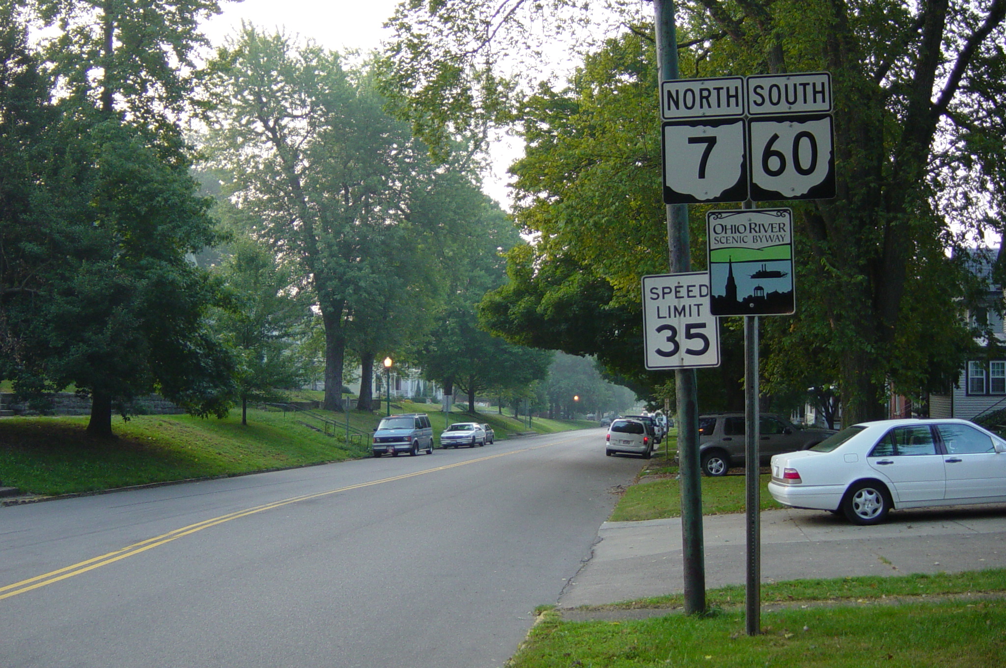
 Signs in Marietta indicating that this stretch of road is simultaneously State Route 7 North and State Route 60 South
- 1924 – Original route established[2]; originally routed from the Indiana state line near Elizabethtown to Conneaut along the current U.S. Route 50 from Indiana to Cleves, the current State Route 264 from Cleves to Bridgetown, currently unnumbered roads from Bridgetown to Cincinnati, current U.S. Route 52 from Cincinnati to Aberdeen, current State Route 41 from Aberdeen to 1-mile (1.6 km) east of Bradyville, a currently unnumbered road from 1-mile (1.6 km) east of Bradyville to Manchester, current U.S. Route 52 from Manchester to 1-mile (1.6 km) south of Chesapeake, its current alignment from 1-mile (1.6 km) south of Chesapeake to North Lima, a currently unnumbered road paralleling Interstate 680 from North Lima to Youngstown, and its current alignment from Youngstown to Conneaut.[3]
- 1926 – Truncated at Chesapeake; Indiana state line to Cleves certified as U.S. Route 50; Cleves to Bridgetown certified as State Route 264; Bridgetown to Cheviot certified as State Route 268; Cincinnati to 7 miles (11 km) east of Cincinnati dually certified as U.S. Route 50 and U.S. Route 52; Chevoit to Chesapeake certified as U.S. Route 52; 1-mile (1.6 km) south of Marietta to 1-mile (1.6 km) north of Newport dually certified with U.S. Route 50N; swapped alignments with State Route 164 from North Lima to Youngstown[3].
- 1935 – 1-mile (1.6 km) south of Marietta to 1-mile (1.6 km) north of Newport dually certified with U.S. Route 50A[3].
- unknown – New 4-lane divided alignment built in Conneaut from the Monroe Township line to just south of U.S. Route 20 (around the time Interstate 90 was constructed in the late 1950s)[citation needed].
- 1962 – Belpre to Marietta upgraded to 4 lanes[3].
- 1966 – Brilliant to Toronto upgraded to 4 lanes[3].
- 1969 – Pomeroy bypass added[3].
- 1970 – Bridgeport to Martins Ferry and Steubenville to East Liverpool upgraded to divided highway; East Liverpool to 5 miles (8.0 km) north of East Liverpool upgraded to freeway[3].
- 1971 – Rush Run, Ohio to Brilliant upgraded to divided highway[3].
- 1972 – 3 miles (4.8 km) north of Powhatan Point to 3 miles (4.8 km) north of Dilles Bottom, and Rayland to Rush Run upgraded to divided highway[3].
- 1974 – 7 miles (11 km) south of Pomeroy to 2 miles (3.2 km) south of Pomeroy upgraded to divided highway[3].
- 1975 – U.S. Route 50A certification removed (1 mile south of Marietta to 1-mile (1.6 km) north of Newport)[3].
- 1976 – 2 miles (3.2 km) south of Pomeroy to Pomeroy, and Yorkville to Rayland upgraded to divided highway[3].
- 1977 – Rush Run to Empire, and 1-mile (1.6 km) south of Wellsville to 5 miles (8.0 km) north of East Liverpool upgraded to freeway[3].
- 1978 – 4 miles (6.4 km) south of Newell Run to 2 miles (3.2 km) south of Newell Run, and Martins Ferry to 2 miles (3.2 km) north of Martins Ferry upgraded to divided highway; 2 miles (3.2 km) north of Martins Ferry to Rush Run upgraded to freeway[3].
- 1979 – Extended 1-mile (1.6 km) south on the former alignment of U.S. Route 52[3].
- 1989 – 3 miles (4.8 km) north of Dilles Bottom to 2 miles (3.2 km) south of Bellaire upgraded to divided highway[3].
- 1993 – 2 miles (3.2 km) south of Bellaire to Bridgeport upgraded to divided highway[3].
Chesapeake and Proctorville bypass
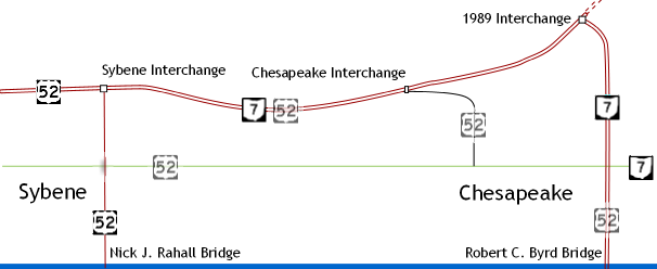
 Historical map of the Chesapeake Bypass
The Chesapeake bypass was first proposed in 1953 [4].
In 1961, the U.S. Route 52 expressway opened from Chesapeake westward towards Sheridan. The original eastern terminus of the four-lane divided highway was at the current Chesapeake northbound-only exit ramp east of Tallow Ridge Road [7]. U.S. Route 52 originally crossed at the present-day Robert C. Byrd Bridge that connects Chesapeake to Huntington, West Virginia. In 1979, the U.S. Route 52 designation moved to the Nick Joe Rahall II Bridge as tolls on that span were removed that year; the segment east of the Rahall Bridge to the Chesapeake interchange was renumbered to State Route 7.
Ten years later, the four-lane expressway was extended eastward to an incomplete trumpet interchange just east of Big Branch Road [8]. A four-lane connector route from the partially complete interchange to the foot of the Robert C. Byrd Bridge at State Route 527 was completed. At the same time, the two-lane Chesapeake interchange ramp just east of Tallow Ridge Road was converted to a northbound-only exit ramp. The abrupt terminus at Chesapeake was envisioned to connect to Proctorville.
 State Route 7 runs through downtown Gallipolis.
On May 31, 2002, [5] ground was broken for Phase 1-A of the Proctorville bypass. [6] Phase 1-A entailed a two-lane connector road from the East Huntington Bridge to Irene Road, with the original loop ramp from the bridge to State Route 7 being modified into an access road. Phase 1-B was designated from Irene Road to State Route 7 near Fairland East Elementary in Rome. Phase 2 was envisioned from Irene Road west to Chesapeake. The total cost was originally estimated to be at $165 million [5].
On April 27, 2003, Phase 1-A of the Proctorville bypass opened to traffic. [7]. The $6.5 million,[5] one-mile (1.6 km) section of three-lane roadway was opened from the foot of the East Huntington Bridge to Irene Road and signed as State Route 607.
On June 3, 2003, bids were opened for Phase 1-B from Irene Road to State Route 7 near Fairland East Elementary. [8] The projected cost of the 4.5-mile (7.2 km) segment was originally $27 million, however, when the bids were let, the cost had decreased to $24.3 million. The lowest bid, which was also accepted, came in at $22.1 million. [9] The road was designed as a two-lane limited-access facility on a four-lane right-of-way. Construction began on August 4 [10], with an original estimated completion date of June 30, 2005.
 State Route 7 south of Dilles Bottom
An unusual amount of rain, blamed on two hurricanes, caused major delays. [11] More than one-dozen major slips along Phase 1-B required an additional $30 million in repairs and the purchase of additional land for highwall excavations. Another change was the design of the roadway; originally projected to be widened in the future when higher traffic counts warrant the expansion, it was designed on wide right-of-way with no grade separation between the opposing lanes. During the repair of the slips, a terraced roadway was constructed to separate the future southbound lanes from the northbound by a highwall when the roadway is expanded to four lanes.
Other cost overruns had pushed the cost of construction to $62 million total, which included Phases 1-A and 1-B, up from the original estimates of $32 million. The primary cause was rapidly increasing land values and "unchecked zoning" along the project's projected right-of-way along with geo-technical problems with rocky soil. [8] Property values along the projected route, for instance, increased 91.5% from 1992 to 2001 alone.
In October 2006, a small 1/2-mile segment of the Phase 1-B bypass opened to traffic between the State Route 607 and Irene Road intersection to State Route 775 [12]. The remainder, east to State Route 7 near Fairland East Elementary, opened on December 8, 2006. It includes intersections with State Route 775, Kinley Avenue, and State Route 7. Upon completion, Phases 1-A and 1-B were signed as State Route 7; the bypass from the State Route 775 junction to the loop at the East Huntington Bridge was co-numbered with State Route 775.
 The highway somewhere between Marietta and Pomeroy
Phase 2 of the bypass, from the Chesapeake bypass to Irene Road at Proctorville, has not been funded. Funding which had been previously promised by the Ohio Department of Transportation was later denied. [4] Phase 2 is estimated to cost $76 million to complete [8]. Also due to the construction delays (slips) on the bypass from SR 775 to Fairland East Elementary School (Phase 1-B), the design of Phase 2 may be realigned to prevent slips during construction.
Pomeroy Bypass
The Pomeroy bypass from Middleport east to U.S. Route 33 was completed in 1968. At the time of completion, the bypass was two lanes but was upgraded to four lanes, divided, in 1976 from State Route 143 to U.S. Route 33 near Rock Springs. The bypass was extended east in 2000 from Rock Springs to a partial diamond interchange with State Route 7 as a four-lane divided expressway. It was initially signed just State Route 7. The diamond interchange was later completed with all connections, and the highway was extended eastward to Ravenswood, West Virginia as U.S. Route 33.
Major intersections
County Location Mile Destinations Notes Lawrence Union Township 0.00 US 52Full-access interchange. 2.28  SR 527
SR 527 leaves to the north (dead ends at an interchange for a proposed bypass to continue east). 2.83 SR 527SR 527 joins from the south; SR 7 continues easterly. 5.09  SR 243
SR 243 joins from the north. 6.08  SR 607
SR 607 passes over SR 7 south–north to a 180° ramp; SR 607 ends 0.10 mi (0.16 km). later to the north (northern terminus). Proctorville 6.75  SR 775
SR 775 begins to the north (southern terminus). Rome Township 7.55 SR 243SR 243 leaves to the north. 9.96 SR 243SR 243 ends to the west (eastern terminus). 15.97  SR 217
SR 217 ends to the west (eastern terminus). Gallia Crown City 20.15  SR 553
SR 553 begins to the northwest (southern terminus). Gallipolis Township 38.68  SR 218
SR 218 ends to the southwest (northern terminus). Gallipolis 41.05  SR 141
SR 141 ends to the west (eastern terminus). 41.78  SR 588
SR 588 ends to the northwest (eastern terminus). 42.36  SR 160
SR 160 begins to the northwest (southern terminus). Gallipolis Township 45.41 US 35US 35 crosses west–east; access to eastbound and from westbound US 35 only. Addison Township 46.08 

 SR 735 to US 35
SR 735 begins to the west (eastern terminus); provides access to westbound and from eastbound US 35. Cheshire 53.50  SR 554
SR 554 ends to the west (eastern terminus). Meigs Middleport 57.44 Hobson Drive Former routing of SR 7 Salisbury Township 59.79  SR 124
SR 124 joins from the west. 60.82  SR 143
SR 143 begins to the north (southern terminus). 63.62 US 33
SR 124
SR 833US 33 joins from the north;
SR 124 leaves to the south;
SR 833 ends to the south (eastern terminus).66.14 US 33US 33 leaves to the east. Chester Township 69.87  SR 248
SR 248 begins to the east (western terminus). Orange Township 77.98  SR 681
SR 681 crosses west–east. Athens Troy Township 81.53 
 US 50 / SR 32
US 50/SR 32 join from the west. Coolville 82.99  SR 144
SR 144 crosses northwest-southeast. Troy Township 86.50* SR 124SR 124 ends to the south (eastern terminus). Washington Belpre Township 89.86  SR 555
SR 555 begins to the west (southern terminus). 91.23  SR 618
SR 618 begins to the east (western terminus); ramps from eastbound to eastbound and westbound to westbound only. 92.08 US 50
 SR 339
US 50 leaves easterly into West Virginia across the Blennerhassett Island Bridge.
SR 339 crosses south–north.Belpre 96.70 
SR 32 to SR 618SR 32 leaves to the east; access from northbound SR 7 to eastbound SR 32 and to westbound SR 618, and from westbound SR 32 and eastbound SR 618 to southbound SR 7. 97.14
SR 618 to SR 32SR 618 ends to the south (eastern terminus); access from southbound SR 7 to eastbound SR 32 and to westbound SR 618, and from westbound SR 32 and eastbound SR 618 to northbound SR 7. Warren Township 107.62  SR 550
SR 550 ends to the west (eastern terminus). Marietta 108.64  SR 676
SR 676 ends to the northwest (eastern terminus). 109.08  SR 60
SR 60SR 60 joins from the northwest. 109.94  SR 26
SR 26SR 26 begins concurrent (southern terminus). 110.12 SR 60SR 60 leaves to the south. 110.28 SR 26SR 26 leaves to the northeast. Marietta Township 111.34 I-77I-77 passes over SR 7 south–north; full-access interchange (I-77 exit 1). Newport Township 126.02  SR 807
SR 807 passes over SR 7 southeast-northwest to a 180° ramp; SR 807 begins 0.10 mi (0.16 km). later to the northwest (northern terminus). New Matamoras 139.03  SR 260
SR 260 begins to the northwest (southern terminus). Monroe Jackson Township 143.44  SR 800
SR 800 begins to the west (southern terminus). Lee Township 149.98  SR 255
SR 255 ends to the north (eastern terminus). Ohio Township 154.31  SR 536
SR 536 joins from the east. 154.71 SR 536SR 536 leaves to the west. Clarington 163.00  SR 78
SR 78SR 78 ends to the west (eastern terminus). 163.54  SR 556
SR 556 ends to the west (eastern terminus). Belmont Powhatan Point 170.87  SR 148
SR 148 crosses northwest–east. 171.86 SR 148SR 148 ends to the south (eastern terminus). Mead Township 178.03  SR 872
SR 872 begins to the southeast (western terminus) via full-access interchange. 181.41 Central Avenue Interchange; former routing of SR 7 Pultney Township 183.48 Central Avenue Interchange with same-direction connections only; former routing of SR 7 Bellaire 184.32  SR 147
SR 147 ends to the northwest (eastern terminus) via full-access interchange. 185.42  SR 149
SR 149 begins to the west (southern terminus) via full-access interchange. Pultney Township 188.19 I-470I-470 passes over SR 7 west–east; full-access interchange (I-470 exit 6). Bridgeport 189.64 


 SR 767 to US 40 / US 250 / I-70
Access from northbound SR 7 to SR 767, US 40, US 250, and I-70 (exit 225); access from these routes to southbound SR 7. 189.83 
US 40 / US 250 to I-70Access from southbound SR 7 to US 40, US 250, and I-70 (exit 225); access from these routes to northbound SR 7. Martins Ferry 191.77  SR 647
SR 647 begins northwest (southern terminus). Jefferson Rayland 198.71  SR 150
SR 150 ends to the west (eastern terminus) via full-access interchange. Wells Township 203.26 Brilliant Salt Run Road Interchange with northbound exit only; former routing of SR 7 204.50 Brilliant Salt Run Road Interchange; former routing of SR 7 Steubenville Township 208.18  SR 151
SR 151 ends to the west (eastern terminus). Steubenville 212.88  SR 43
SR 43SR 43 begins to the west (southern terminus). 213.98 US 22
 SR 822
US 22 leaves to the east; SR 822 joins from the west here and leaves to the east 0.23 mi (0.37 km). later. Island Creek Township 215.23 US 22
 SR 213
Full-access interchange; US 22 joins from the west; SR 213 begins to the northwest (southern terminus). 216.12 Kingsdale Road Interchange with northbound exit/southbound entrance only; former routing of SR 7 217.17 Kingsdale Road Interchange with northbound entrance/southbound exit only; former routing of SR 7 Empire 224.96  SR 152
SR 152 ends to the west (northern terminus) via full-access interchange. Saline Township 230.02 SR 213SR 213 ends to the southwest (northern terminus). Columbiana Wellsville 232.15  SR 39
SR 39SR 39 joins from the northwest via full-access interchange. 233.64  SR 45
SR 45SR 45 begins to the northwest (southern terminus) via full-access interchange. East Liverpool 236.86 US 30 / SR 11 / SR 39
 SR 267
US 30/SR 11/SR 39 join from/leave to the south; SR 267 begins to the northwest (southern terminus); full-access interchange except from eastbound US 30/southbound SR 7/southbound SR 11 to SR 267. St. Clair Township 240.19  SR 170
SR 170 begins to the northeast (southern terminus). Madison Township 242.68 US 30 / SR 11
SR 267US 30/SR 11 join from/leave to the northwest; SR 267 ends to the south (northern terminus); full-access interchange. Rogers 250.90  SR 154
SR 154 crosses west–east. Fairfield Township 253.13 
 SR 517 / SR 558
SR 517 ends to the west (eastern terminus) concurrent with SR 558 which crosses west–east. 256.18  SR 46
SR 46SR 46 joins from the southeast. Columbiana 257.70  SR 14 / SR 46
SR 46 leaves to the west, concurrent with SR 14 which crosses west–east. Mahoning Beaver Township 261.89  SR 165
SR 165 crosses west–east. 262.19  SR 164
SR 164 crosses southwest-northeast. 263.45 I-76 / Ohio Tpk.Access via ramps here; turnpike passes over SR 7 northwest-southeast 0.30 miles (0.48 km) later; I-76 exit 232. 264.94  SR 626
SR 626 ends to the southeast (northern terminus). Boardman Township 267.46  US 224
US 224 crosses west–east. Youngstown 270.00 SR 170SR 170 crosses west–east. 270.86  US 62
US 62US 62 joins from the west. 271.83 Market Street Former routing of SR 7 272.16  I-680
I-680I-680 passes under US 62/SR 7 northwest-south; access from southbound US 62/SR 7 to I-680 and from I-680 to northbound US 62/SR 7 only (I-680 exit 6). 273.42  SR 289
SR 289 passes over US 62/SR 7 west–east; northbound exit/southbound entrance only. 273.69 
 US 422 / US 62 Truck
Expressway’s terminus ahead (truck route) to Albert St.; ramps to continue northbound on US 62/SR 7 and join US 422 westbound 0.55 miles (0.89 km) later; US 422 continues east. 274.62 US 422US 62/SR 7 leave expressway to the north; US 422 continues (joins from the) west. Trumbull Hubbard 279.94  SR 304
SR 304 joins from the west. 280.78 SR 304
 SR 616
SR 304 continues to the east; SR 616 ends to the south (northern terminus). Hubbard Township 282.06 Elmwood Road Former routing of US 62 282.16 I-80I-80 passes over US 62/SR 7 west–east (I-80 exit 234). 282.92 US 62US 62 leaves to the northeast; northbound split of concurrency; no access from southbound to northbound on either route. 283.35
To US 62Connector provides access from southbound on either route to northbound on the other route. Brookfield Township 285.81  SR 82
SR 82SR 82 crosses west–east. Brookfield Center 286.19 Warren–Sharon Road Former routing of SR 82 Hartford Township 291.49  SR 305
SR 305 crosses west–east. Vernon Township 296.75  SR 88
SR 88SR 88 crosses west–east. Kinsman Township 300.74 SR 5SR 5 joins from the west. 301.93  SR 87
SR 87SR 87 ends to the west (eastern terminus). 302.28 SR 5SR 5 leaves to the east. Ashtabula Williamsfield Township 307.42  US 322
US 322 crosses west–east. Andover 312.55  US 6
US 6
 SR 85
SR 85US 6 joins from the west; SR 85 begins to the east (western terminus). Richmond Township 320.00 US 6US 6 leaves to the east. Pierpont Township 322.56  SR 167
SR 167 joins from the west. 323.47 SR 167SR 167 leaves to the east. Monroe Township 330.24  SR 84
SR 84SR 84 crosses west–east. Conneaut 333.95 I-90I-90 passes under SR 7 west–east; full-access interchange (I-90 exit 241). 335.93  US 20
US 20US 20 joins from the west. 336.15 US 20US 20 leaves to the east. 337.37 SR 531SR 531 ends to the west (eastern terminus). 1.000 mi = 1.609 km; 1.000 km = 0.621 mi - Mileage for OH 124 intersection estimated until diagrams are created that reflect the November 2009 relocation of the intersection.
Auxiliary routes
Alternate State Route 7 in Bridgeport
Alternate State Route 7 is a short connecting loop (0.72 miles[13]) that serves as a link from State Route 7, U.S. Route 40, and U.S. Route 250 to Interstate 70 in Bridgeport. Its western (southern) terminus is at State Route 767, and its eastern (northern) terminus is along U.S. Route 40 at its intersection with U.S. Route 250 and the northern terminus of State Route 767. Route 7A begins at the intersections of Howard Street and SR 767, South Lincoln Avenue. Route 7A continues West as Howard Street until it intersects Marion Street. Route 7A then runs North as Marion Street, intersects I-70, and then intersects US 40, Main Street. Route 7A continues East on US 40 until it ends at US 250.
The entire route is in Bridgeport, Belmont County.Mile Destinations Notes 0.00 SR 767SR 767 passes south–north just north of its interchange with SR 7. 0.38 I-70I-70 passes under SR 7 Alt west–east; full-access interchange (I-70 exit 225). 0.46 US 40SR 7 Alt joins US 40 which enters from the west. 0.72
US 40 - US 250
SR 767US 40 continues east, concurrent with US 250 which joins from the north; northern terminus of SR 767. 1.000 mi = 1.609 km; 1.000 km = 0.621 mi Business State Route 7 from Middleport to Pomeroy
Business State Route 7 stretches from 1¾ miles west of Middleport to about 4 miles (6.4 km) east of Pomeroy. This route follows the former alignment of State Route 7 that was replaced by the Pomeroy Bypass, and runs through the downtown areas of Middleport and Pomeroy. It joins with State Route 833 (the former alignment of U.S. Route 33) from a mile west of Pomeroy to 1¾ east of Pomeroy, including a brief concurrency with State Route 124, and then heads northeast to the eastern U.S. Route 33/State Route 7 interchange. This route is not listed at ODOT’s Technical Services Straight Line Diagrams as a state-maintained route.
Route 7T
Route 7T is a 0.36-mile (0.58 km)-long[13] temporary route beginning at US 62 in Youngstown. Route 7T dead ends but it is unclear from the straight line diagrams where Route 7T begins and ends.
References
- ^ a b "RI82B: Centerline Miles, Lane Miles, and VMT by Route and County". Transportation System Development, Ohio Department of Transportation, 2008-05-13. Retrieved 2009-08-04.
- ^ Explanation of the Ohio State Highway System (The Unofficial Ohio State Highways Web Site) by John Simpson
- ^ a b c d e f g h i j k l m n o p q Route 7 (The Unofficial Ohio State Highways Web Site) by John Simpson
- ^ a b Malloy, David. "Chesapeake Bypass on hold indefinitely." Herald-Dispatch [Huntington] 2004. 11 Feb. 2007.
- ^ a b c Malloy, David. "Chesapeake bypass gets aid from feds." Herald-Dispatch [Huntington] 2002. 11 February 2007.
- ^ Blair, Allen. "Bypass construction set in Lawrence, Ohio." Daily Independent [Ashland] 2002. 11 February 2007.
- ^ Malloy, David. "Traffic eased in Proctorville, but congested elsewhere." Herald-Dispatch [Huntington] 27 April 2003. 11 February 2007 [1].
- ^ a b c Malloy, David. "Overruns raise concerns about bypass." Herald-Dispatch [Huntington] 23 May 2003. 11 February 2007 [2].
- ^ Malloy, David. "Bids opened for Chesapeake Bypass project." Herald-Dispatch [Huntington] 5 June 2003. 11 Feb. 2007 [3]/
- ^ Malloy, David. "Chesapeake Bypass construction to start." Herald-Dispatch [Huntington] 11 July 2003. 11 Feb. 2007 [4].
- ^ Malloy, David. "Bridge work may be bid on in fall." Herald-Dispatch [Huntington] 15 April 2005. 11 Feb. 2007 [5].
- ^ Malloy, David. "Section of new Chesapeake Bypass could open next week." Herald-Dispatch [Huntington] 21 Oct. 2006. 11 Feb. 2007 [6].
- ^ a b Mileages retrieved from Technical Services Straight Line Diagrams unless otherwise noted.
External links
Categories:- State highways in Ohio
- Transportation in Ashtabula County, Ohio
- Transportation in Athens County, Ohio
- Transportation in Belmont County, Ohio
- Transportation in Columbiana County, Ohio
- Transportation in Gallia County, Ohio
- Transportation in Jefferson County, Ohio
- Transportation in Lawrence County, Ohio
- Transportation in Mahoning County, Ohio
- Transportation in Meigs County, Ohio
- Transportation in Monroe County, Ohio
- Transportation in Trumbull County, Ohio
- Transportation in Washington County, Ohio


Wikimedia Foundation. 2010.