- Coolville, Ohio
-
Not to be confused with Coolsville, Ohio, a fictional city in the cartoon series Scooby Doo.
Coolville, Ohio — Village —  Location of Coolville, Ohio
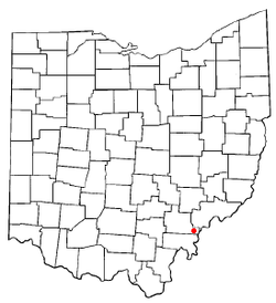
Coordinates: 39°13′20″N 81°47′52″W / 39.22222°N 81.79778°WCoordinates: 39°13′20″N 81°47′52″W / 39.22222°N 81.79778°W Country United States State Ohio County Athens Area – Total 0.9 sq mi (2.2 km2) – Land 0.8 sq mi (2.2 km2) – Water 0.0 sq mi (0.1 km2) Elevation[1] 699 ft (213 m) Population (2000) – Total 528 – Density 627.1/sq mi (242.1/km2) Time zone Eastern (EST) (UTC-5) – Summer (DST) EDT (UTC-4) ZIP code 45723 Area code(s) 740 FIPS code 39-18588[2] GNIS feature ID 1048628[1] Coolville is a village located in Troy Township, Athens County, Ohio, United States, in the extreme southeast of the state. The population was 528 at the 2000 census.
Contents
Geography
Coolville is located at 39°13′20″N 81°47′52″W / 39.22222°N 81.79778°W (39.222197, -81.797639)[3].
It is located on the right bank (west bank) of the Hocking River, a few miles upstream from its confluence with the Ohio River. US-50 / OH-32 / OH-7, the Appalachian Highway, bypasses the town on the north side, just outside the built-up area, and provides highway access to the community. OH-144, located on the far bank of the Hocking River, also provides access.
According to the United States Census Bureau, the village has a total area of 0.9 square miles (2.3 km2), of which, 0.8 square miles (2.1 km2) of it is land and 0.04 square miles (0.10 km2) of it (3.45%) is water.
Demographics
As of the census[2] of 2000, there were 528 people, 213 households, and 148 families residing in the village. The population density was 627.1 people per square mile (242.7/km²). There were 232 housing units at an average density of 275.5 per square mile (106.6/km²). The racial makeup of the village was 98.86% White, 0.38% from other races, and 0.76% from two or more races.
There were 213 households out of which 29.6% had children under the age of 18 living with them, 53.5% were married couples living together, 11.7% had a female householder with no husband present, and 30.5% were non-families. 24.9% of all households were made up of individuals and 14.6% had someone living alone who was 65 years of age or older. The average household size was 2.48 and the average family size was 2.94.
In the village the population was spread out with 25.9% under the age of 18, 6.4% from 18 to 24, 28.2% from 25 to 44, 24.1% from 45 to 64, and 15.3% who were 65 years of age or older. The median age was 36 years. For every 100 females there were 100.8 males. For every 100 females age 18 and over, there were 91.7 males.
The median income for a household in the village was $31,731, and the median income for a family was $37,500. Males had a median income of $38,889 versus $23,500 for females. The per capita income for the village was $17,639. About 12.0% of families and 15.6% of the population were below the poverty line, including 25.9% of those under age 18 and 18.3% of those age 65 or over.
Public services
The residents of Coolville are served by the Federal Hocking Local School District and Federal Hocking High School in Stewart. They are also served by the Athens County Public Libraries with branches in Albany, Athens, Chauncey, Coolville, Glouster, Nelsonville, and The Plains.
Name
Coolville was named for the late Ashel Cooley and his family.
Coolville is located close to three other "hot/cold" communities: Torch and Frost (both unincorporated communities in Athens County), and Snowville in Meigs County.
References
- ^ a b "US Board on Geographic Names". United States Geological Survey. 2007-10-25. http://geonames.usgs.gov. Retrieved 2008-01-31.
- ^ a b "American FactFinder". United States Census Bureau. http://factfinder.census.gov. Retrieved 2008-01-31.
- ^ "US Gazetteer files: 2010, 2000, and 1990". United States Census Bureau. 2011-02-12. http://www.census.gov/geo/www/gazetteer/gazette.html. Retrieved 2011-04-23.
External links
Municipalities and communities of Athens County, Ohio Cities 
Villages Townships CDP Unincorporated
communitiesBurr Oak | Carbondale | Canaanville | Guysville | Hockingport | Millfield | Mineral | Modoc | New Marshfield | Redtown | Shade | Sharpsburg | Stewart
Footnotes ‡This populated place also has portions in an adjacent county or counties
Categories:- Villages in Ohio
- Populated places in Athens County, Ohio


Wikimedia Foundation. 2010.