- Ohio State Route 32
-
State Route 32
Route information Maintained by ODOT Length: 182.69 mi[1] (294.01 km) Existed: 1962[citation needed] – present Major junctions West end:  US 50 in Cincinnati
East end:  WV 618 on Parkersburg-Belpre Bridge in Belpre
Highway system Ohio highways
Interstates • U.S. Routes • State Routes←  SR 31
SR 31SR 34  →
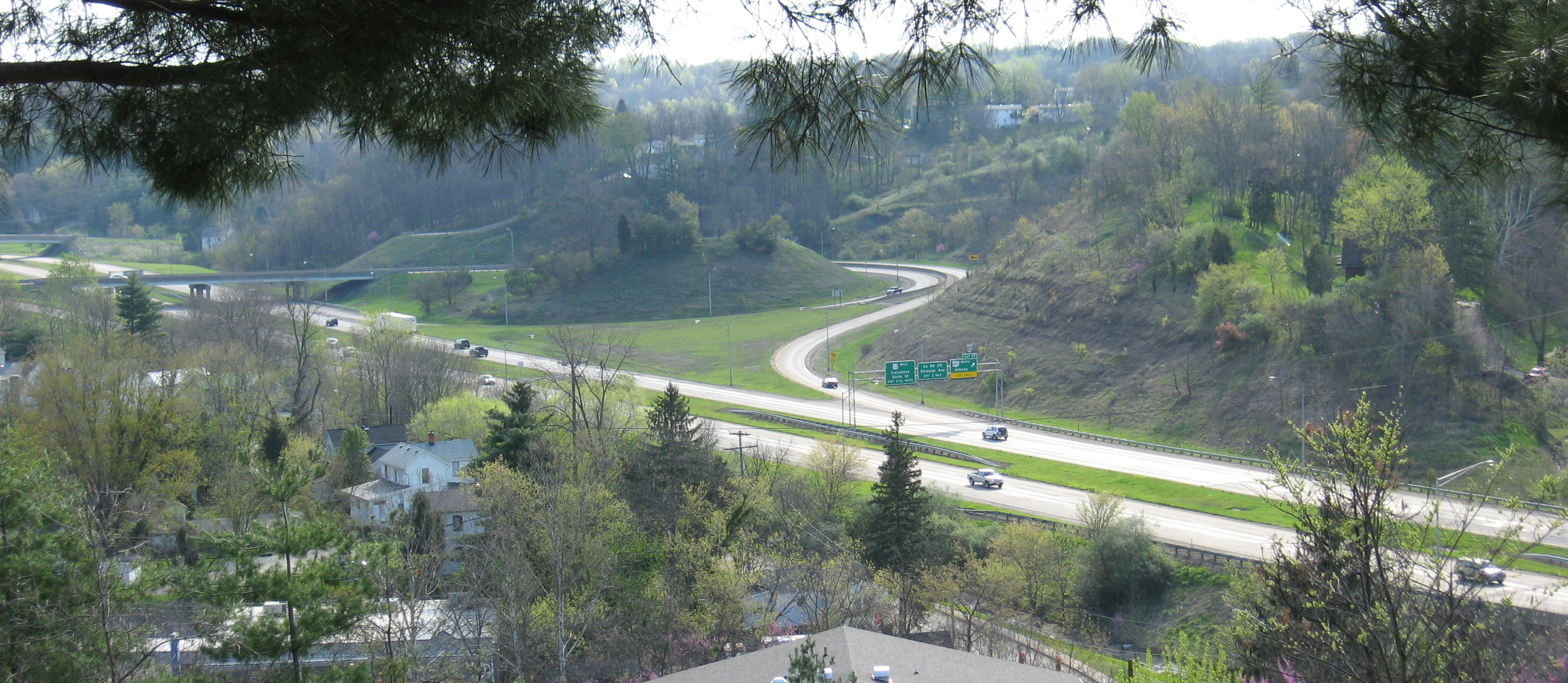
→ In Jackson County, State Route 32 overpasses U.S. Route 35 as State Route 93 (background) overpasses U.S. 35

State Route 32, also known as the James A. Rhodes Appalachian Highway,[2] is a major east–west highway across the southern portion of the U.S. state of Ohio. It leads from eastern Cincinnati, near the border between the neighborhoods of Linwood, Mount Lookout, and Columbia-Tusculum, to the Parkersburg-Belpre Bridge across the Ohio River in Belpre.
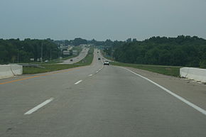
Except in Belpre, leading up to the bridge into West Virginia, the entire route outside Cincinnati's beltway (Interstate 275) is a high-speed four-lane divided highway, forming the Ohio portion of Corridor D of the Appalachian Development Highway System. This corridor continues east across the Ohio River over the Blennerhassett Island Bridge.
History
The Batavia Turnpike and Miami Bridge Company was incorporated and chartered by the state of Ohio. It built a road, which was "about finished" as of 1841, beginning at the Wooster Turnpike (Eastern Avenue), crossing the Little Miami River on the Union Bridge, and turning east to Batavia.[3][4] The Ohio Turnpike to Bethel split after the Little Miami was crossed.
The passage of the McGuire Bill in 1911 led to the designation of a large number of Inter-County Highways to be maintained by the Ohio Department of Highways.[5] This network included the Cincinnati-Batavia Road (ICH 41) and Batavia-Winchester Road (ICH 125), connecting Cincinnati to Batavia, Williamsburg, Mt. Orab, Sardinia, Winchester, and beyond to an intersection with the West Union-Belfast Road (ICH 122) south of Seaman (where Graces Run Road now meets State Route 247). This entire route from Cincinnati to south of Seaman was designated and signed as State Route 74 in 1923. The route left downtown Cincinnati on Eastern Avenue, shared with State Route 7 (now U.S. Route 52) and State Route 25 (now State Route 125). SR 7 left at Davis Lane (now Airport Road), while SR 25 and SR 74 turned onto Beechmont Avenue, splitting after crossing the Little Miami River. By 1925, the east end of SR 74 had been realigned and extended, heading east from Winchester through Seaman and continuing through Peebles to State Route 73 northwest of Rarden; the old alignment (Graces Run Road) reverted to local control. Along with U.S. Route 50, US 52, and SR 125, SR 74 was moved to Columbia Parkway in the early 1940s, and in the early 1950s it was removed from downtown Cincinnati to its present terminus. Due to the existence of Interstate 74 west of Cincinnati, the number was changed to State Route 32 in 1962, with SR 74 signs being removed in June 1963 after a period of dual signage.[6]
The state relocated the road between Mount Carmel and Batavia as a four-lane divided highway in the early 1960s, several years after the parallel State Route 125 was widened (but not realigned). Because this was done before or during the renumbering, the old road here is known as Old State Route 74, rather than Old State Route 32 to the east. Improvement of the rest of the road did not take place until after it was added to the Appalachian Development Highway System in 1965.[7] This proposed Appalachian Highway – part of Corridor D – was to run across the southern part of the state from Interstate 275 outside Cincinnati to Belpre.[8] From the east end of SR 32 east of Peebles, the route was to continue northeast, joining State Route 772 near Elmgrove, and following State Route 124 beyond Jackson to Roads. After continuing northeast to Radcliff, it would parallel State Route 346 and a portion of State Route 143, merging with U.S. Route 50 west of Albany and following it past Athens and Coolville to Belpre. A never-built branch, planned as part of Corridor B,[9] would have followed State Route 73 and State Route 348 from east of Peebles to Lucasville on U.S. Route 23 (Corridor C).[6]
Major intersections
County Location Mile[1] Road(s) Notes Hamilton
(7.48 mi)Cincinnati 0.00 

 US 50 (Columbia Parkway) – Cincinnati; US 50 Truck (Eastern Avenue); SR 561 north (Linwood Avenue)
Interchange; SR 125 also begins here, overlapping SR 32 0.29 Wilmer Avenue; Wooster Road Interchange 1.53  SR 125 east (Beechmont Avenue)
Interchange; east end of SR 125 overlap Clermont
(16.44 mi)8.97  I-275 to US 52 – Kentucky; to I-71 – Columbus
Interchange; exit 63 of I-275 9.43 Eastgate Boulevard Interchange 12.46 Olive Branch-Stonelick Road Interchange Batavia 14.32 Main Street; Kent Road – Batavia Interchange; eastbound exit and westbound entrance 14.90 
 SR 132/SR 222 – Owensville; Batavia
Interchange 18.06 James Sauls Jr Drive (Formerly Front Wheel Drive); Batavia Road Interchange 19.62 Half Acre Road Interchange 21.43  SR 133 – Williamsburg
Interchange Brown
(8.21 mi)Mt. Orab 29.15  US 68 – Fayetteville; Mt. Orab
Interchange Highland
(0.39 mi)No major junctions Brown
(1.42 mi)No major junctions Highland
(0.19 mi)No major junctions Brown
(9.96 mi)Sardinia 35.61  SR 134 north
41.18  US 62
US 62Adams
(24.85 mi)Winchester 45.80  SR 136
Seaman 50.38  SR 247
58.80  SR 41
SR 4164.08  SR 73
SR 73Pike
(28.42 mi)76.87  SR 772 south
West end of SR 772 overlap 78.96  SR 124 west; SR 772 north
West end of SR 124 overlap; east ond of SR 772 overlap 82.66  SR 104
84.16  US 23 – Portsmouth; Chillicothe
Interchange 88.94  SR 220 north
94.81  SR 335
Jackson
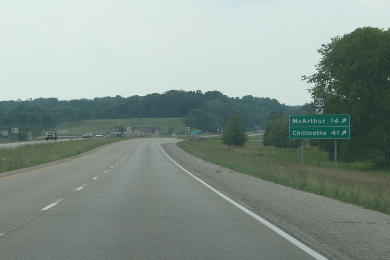
(24.46 mi)102.82  SR 776
105.78  SR 139
108.20  SR 93 – Jackson; Oak Hill
Interchange 109.11  US 35 – Gallipolis; Jackson; Chillicothe
Interchange 114.49  SR 124 east; SR 327
East end of SR 124 overlap Vinton
(7.67 mi)125.02  SR 160
Meigs
(3.82 mi)130.94  SR 689 south
Athens
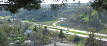
(38.72 mi)133.71  SR 143
134.73 US 50 westWest end of US 50 overlap Albany 136.86  SR 681
Interchange Athens 145.06  US 33 east – Pomeroy; Richland Avenue
Interchange; west end of US 33 overlap; exit 18 of US 33 145.71  SR 682 north to SR 56 – Athens
Interchange; exit 17 of US 33 146.68
147.01CR 25; Stimson Avenue Interchange; exit 16C of US 33 147.13 US 33 west – Columbus; State StreetInterchange; east end of US 33 overlap; exit 16 of US 33 149.80 State Street Interchange 152.24  SR 690
156.95  SR 329
166.36  SR 7 south
Interchange; west end of SR 7 overlap 167.90  SR 144
Washington
(10.66 mi)174.14 SR 124 west174.70  SR 555 north
175.57  SR 618 east
Interchange; eastbound exit and westbound entrance Beverly 176.92 US 50 East
 SR 339
Interchange; US 50 enters West Virginia over Blennerhassett Island Bridge.
East end of US 50 overlapBelpre 181.77 SR 7 north; SR 618 eastInterchange; east end of SR 7 overlap; west end of SR 618 overlap 182.55 SR 618 westEast end of SR 618 overlap 182.69 Parkersburg-Belpre Bridge over the Ohio River References
- ^ a b Ohio Department of Transportation Office of Technical Services: Straight Line Diagrams, current as of January 1, 2007
- ^ Ohio Revised Code, Title 55, Chapter 5533, Section 26: James A. Rhodes appalachian highway
- ^ Henry A. Ford, A. M. and Mrs. Kate B. Ford, History of Hamilton County Ohio, 1881, p. 347
- ^ Charles Cist, Cincinnati in 1841: Its Early Annals and Future Prospects, p. 81
- ^ Ohio Department of Transportation, Right of Way Plan ManualPDF (346 KiB), p. 3 (History of Roadways in Ohio), accessed June 30, 2007
- ^ a b Ohio Department of Transportation, Ohio Transportation Maps, including 1912 (first one to show the Inter-County Highways), 1917 (lists the Inter-County Highways by name), 1926 (shows the routing in Cincinnati), 1962 (describes the renumbering), 1969 (shows the proposed Appalachian Highway)
- ^ Brett Dunlap, Parkersburg News and Sentinel, Bridge remains last major hurdle for Corridor D, June 30, 2007
- ^ Hillsboro Press Gazette, 175 Miles of Appalachian Road Okayed, August 3, 1965
- ^ Hillsboro Press Gazette, Ohio Appalachian Highway Progressing; 38.5 Miles Built, August 8, 1969
Categories:- State highways in Ohio
- Transportation in Hamilton County, Ohio
- Transportation in Clermont County, Ohio
- Transportation in Brown County, Ohio
- Transportation in Highland County, Ohio
- Transportation in Adams County, Ohio
- Transportation in Pike County, Ohio
- Transportation in Jackson County, Ohio
- Transportation in Vinton County, Ohio
- Transportation in Meigs County, Ohio
- Transportation in Athens County, Ohio
- Transportation in Washington County, Ohio
- Transportation in Cincinnati, Ohio


Wikimedia Foundation. 2010.