- U.S. Route 50 in Ohio
-
This article is about the section of U.S. Route 50 in Ohio. For the entire length of the highway, see U.S. Route 50.
U.S. Route 50
Route information Maintained by ODOT Length: 209 mi[1] (336 km) Major junctions West end:  US 50 at IN state line near Cleves
 I-275 near Cincinnati


 I-71 / I-75 / I-471 in Cincinnati
I-275 near Milford
 US 68 in Fayetteville
 US 62 in Hillsboro

 US 23 / US 35 in Chillicothe
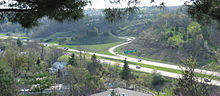
 US 33 in Athens
East end: US 50 at WV state line at the Ohio RiverHighway system United States Numbered Highways
List • Bannered • Divided • ReplacedOhio highways
Interstates • U.S. Routes • State Routes←  SR 49
SR 49SR 51  →
→U.S. Route 50 runs east–west across the southern part of the U.S. state of Ohio, passing through Cincinnati, Chillicothe, and Athens. It is mainly a two-lane road except for the easternmost part. Near Athens it becomes part of State Route 32, a four-lane divided highway known as Corridor D, and from Reedsville to the Ohio/West Virginia border it also overlaps State Route 7 before crossing into Parkersburg, West Virginia.
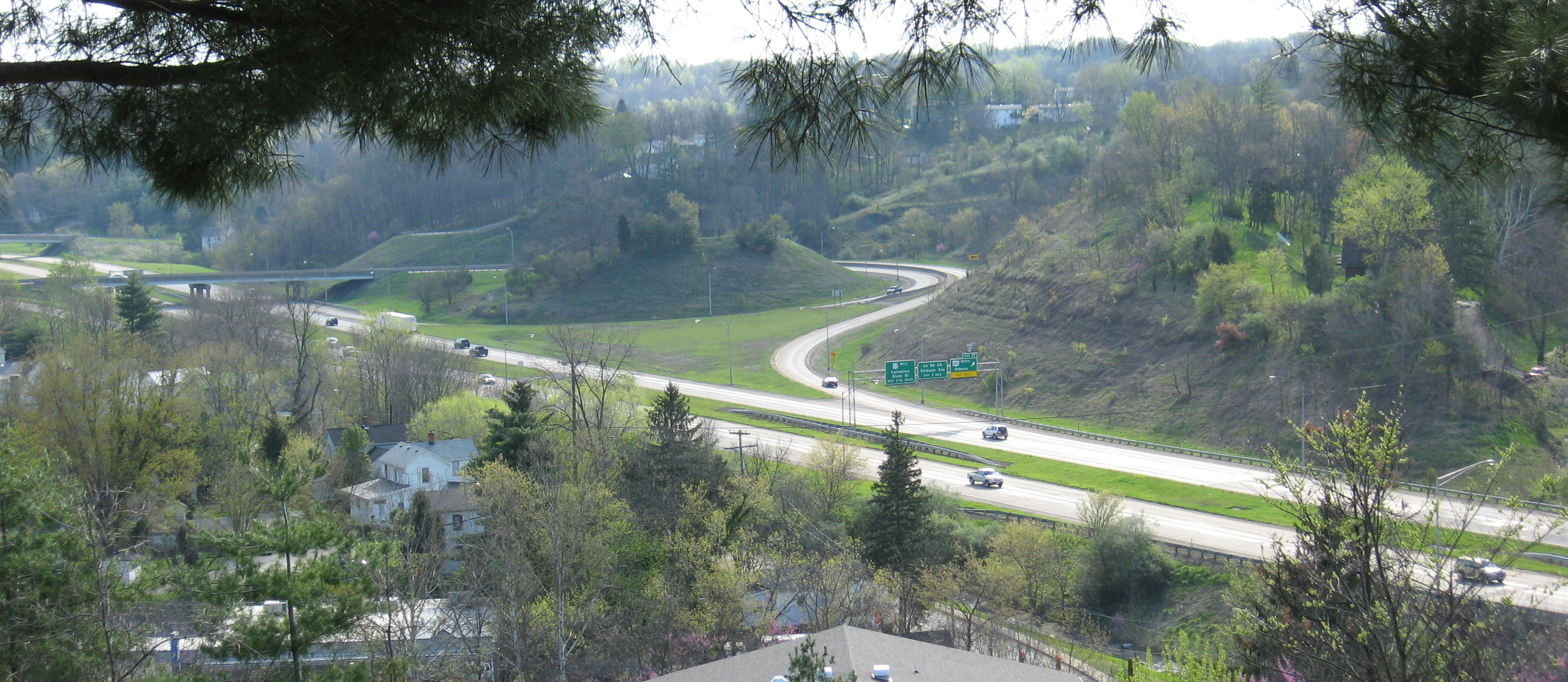
 A view of U.S. 50 (traveling west) near Albany, Ohio as it is about to leave the concurrency with SR 32
Route description
US 50 enters Ohio from Indiana near Lawrenceburg, immediately crossing under Interstate 275 before entering the extreme western suburbs of the greater Cincinnati area. US 50 (known in this area as River Road) follows the Ohio River until entering the villages of Cleves and North Bend, where a monument and tomb of President William Henry Harrison stands on the eastbound side of the road. In Cincinnati it is routed along the Sixth Street Expressway, Fort Washington Way, and the historic Columbia Parkway (from which trucks are banned). In Fairfax, US 50 becomes known as Wooster Pike and crosses the Little Miami River via the Wooster Pike Bridge in Milford. East of Milford, US 50 becomes a two-lane highway as it travels through Hillsboro and Bainbridge before reaching the outskirts of Chillicothe. In Chillicothe, US 50 becomes Western Avenue and then Main Street before merging with U.S. Route 23 and U.S. Route 35 east of the city. State Route 104 overlaps US 50 through downtown Chillicothe. As US 50 leaves Chillicothe it becomes a two-lane highway once again as it winds its way through McArthur and heavy forested Southern Ohio before reaching the outskirts of Athens where it becomes a four-lane highway. It will remain four-lane until reaching the Ohio River. US 50 joins with State Route 32 near the Ohio University Bush Airport–Snyder Field in Albany, west of Athens. US 50 intersects with U.S. Route 33 east of the city before continuing eastward toward Belpre and the Ohio River. US 50 begins to overlap SR 7 near Reedsville as it heads north along the river, and splits from SR 7 before it crosses the river on the Blennerhassett Island Bridge to Parkersburg, West Virginia.
Junction list
County Location Mile[2] Destinations Notes Indiana state line Hamilton Elizabethtown 0.2 I-275No access Cleves 3.7  SR 128
Southern terminus of OH-128 4.5  SR 264
Western terminus of OH-264 Cincinnati 18.6 SR 264Western end of concurrency with OH-264 20.1 


 US 27 / US 42 / US 52 / US 127
Eastern end of concurrency with OH-264
Exit to US 27/42/52/12720.2 I-71 south / I-75 – Dayton, LexingtonWestern end of concurrency with I-71, I-71 exit 1G; I-71/I-75 N exit 1D; I-75 S exit 1G 21.2 I-71 north – ColumbusEastern end of concurrency with I-71, I-71 exit 1J 21.8 I-471 NewportI-471 S only, I-471 exit 6A 27.7 

 SR 32 / SR 125 / SR 561
Western termini of OH-32 and OH-125
Southern terminus of OH-561Terrace Park 36.1  SR 126
Eastern terminus of OH-126 Clermont Milford 37.0  SR 28
SR 28Western terminus of OH-28 37.7  SR 131
Western terminus of OH-131 39.2 I-275I-275 exit 59, via Milford Parkway Stonelick 43.7  SR 222
Northern terminus of OH-222 Owensville 46.9  SR 132
Western end of concurrency with OH-132 47.3  SR 132 / SR 276
Eastern end of concurrency with OH-132
Northern terminus of OH-276Monterey 51.0  SR 133
Marathon 54.3  SR 286
Western terminus of OH-286 Brown Vera Cruz 57.4 SR 131Fayetteville 59.3 US 68St. Martin 61.3  SR 251
Southern terminus of OH-251 Highland Dodsonville 65.7  SR 134
Western end of concurrency with OH-134 65.8 SR 134Eastern end of concurrency with OH-134 Allenburg 67.8  SR 135
Southern terminus of OH-135 Hillsboro 76.2  SR 124
Western end of concurrency with OH-124 76.7 
 US 62 / SR 73 / SR 138
77.2 SR 124Eastern end of concurrency with OH-124 Rainsboro 86.2  SR 753
Western end of concurrency with OH-753 87.1 SR 753Eastern end of concurrency with OH-753 Ross Bainbridge 94.7  SR 41
SR 41Western end of concurrency with OH-41 95.6 SR 41Eastern end of concurrency with OH-41 Slate Mills 110.0 SR 28Eastern terminus of OH-28 Chillicothe 114.7  SR 104
Western end of concurrency with OH-104 115.0  SR 772
Northern terminus of OH-772 115.4 

US 23 BUS/OH-104/OH-159Eastern end of concurrency with OH-104; Southern terminus of OH-159 116.8 US 23 / US 35Western end of concurrencies with US 23 and US 35; Interchange 118.0 US 23 south – PortsmouthEastern end of concurrency with US 23
InterchangeSchrader 119.7 US 35 east – JacksonEastern end of concurrency with US 35
InterchangeLondonderry 127.2  SR 327
Western end of concurrency with OH-327 Vinton 131.2 SR 327Eastern end of concurrency with OH-327 Ratcliffburg 134.4  SR 671
Eastern terminus of OH-671 Allensville 139.9  SR 683
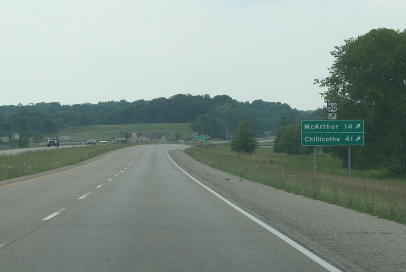
Northern terminus of OH-683 McArthur 146.7  SR 93
SR 93149.3  SR 677
Southern terminus of OH-677 Prattsville 152.1  SR 278
Southern terminus of OH-278 Bolins Mills 157.9  SR 356
Southern terminus of OH-356 Athens Albany 160.2  SR 143
Northern terminus of OH-143 161.1 SR 32Western end of concurrency with OH-32 163.3  SR 681
Athens 171.2 US 33 east – Pomeroy, RavenswoodWestern end of concurrency with US 33; Exit 18 172.1  SR 682
Southern terminus of OH-681; Exit 17 173.7 US 33 west – ColumbusEastern end of concurrency with US 33; Exit 16 Canaanville 178.7  SR 690
Southern terminus of OH-690 Guysville 183.3  SR 329
Southern terminus of OH-329 Coolville 192.7  SR 7 – Pomeroy, Gallipolis
Western end of concurrency with OH-7
Interchange194.2  SR 144
Washington Little Hocking 200.5 SR 124Eastern terminus of OH-124 Redbush 201.0  SR 555
Southern terminus of OH-555 Porterfield 202.4  SR 618
Western terminus of OH-618 203.3  SR 339
Interchange 203.9 SR 7 / SR 32Eastern end of concurrencies with OH-7 and OH-32
Interchange204.2 SR 618Blennerhassett Island Bridge, West Virginia state line References
- ^ Federal Highway Administration, National Highway Planning Network GIS data version 2005.08
- ^ Google Maps
U.S. Route 50Previous state:
IndianaOhio Next state:
West VirginiaCategories:- U.S. Route 50
- U.S. Highways in Ohio
- Transportation in Cincinnati, Ohio

Wikimedia Foundation. 2010.