Washington State Route 509
- Washington State Route 509
Infobox WA State Route
type=State
route=509
parent_type=Interstate
parent=5
sec=680
length_mi=35.16
length_ref=
length_round=2
formed=1964
dir1=South
dir2=North
from=
junction=
to=
previous_type=WA
previous_route=508
next_type=WA
next_route=510
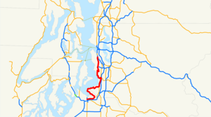
State Route 509 is a state highway in the U.S. state of Washington. It extends just over 35 miles (56.6 km) from Tacoma in the south to Seattle in the north.
Route description
Originating at Interstate 705 in Tacoma, it travels over a cable-stayed bridge as a four-lane limited access highway east towards Fife before turning northward, skirting the Tacoma tideflats and rounding Brown's Point to Dash Point State Park. Entering King County it winds on top of the bluff along the south shore of Poverty Bay through Federal Way until connecting with State Route 99. It then follows SR 99 and State Route 516 into Des Moines and Normandy Park. It continues north as a four-lane freeway, skirting the western edge of the Seattle-Tacoma International Airport and intersecting State Route 518 in Burien. The route descends to the Duwamish River and terminates in the Industrial District south of downtown Seattle, where it rejoins State Route 99.
Proposed extension
A proposal to link SR 509 directly to I-5 south of Sea-Tac Airport is expected to relieve congestion by attracting much truck traffic to the more direct route. The project will also include adding extra lanes to the section of I-5 that is south of the SR 509 interchange to accommodate additional traffic.
Major intersections
References
External links
* [http://www.angelfire.com/wa2/hwysofwastate/sr509.html Highways of Washington State]
* [http://www.wsdot.wa.gov/Projects/I5/SR509FreightCongestionRelief/default.htm Project page for the proposed SR 509 expansions]
Wikimedia Foundation.
2010.
Look at other dictionaries:
Washington State Route 525 — State Route 525 Whidbey Scenic Isle Way … Wikipedia
Washington State Route 518 — infobox WA State Route type=WA route=518 sec=715 parent=5 parent type=Interstate length mi=3.42 length ref= length round=2 formed=1964 dir1=West dir2=East from= junction= to= previous type=WA previous route=516 next type=WA next route=519State… … Wikipedia
Washington State Route 203 — Karte … Deutsch Wikipedia
Washington State Route 516 — infobox WA State Route type=WA route=516 sec=710 parent=5 parent type=Interstate length mi=16.49 length ref= length round=2 formed=1964 dir1=West dir2=East from= junction= to= previous type=WA previous route=515 next type=WA next route=518State… … Wikipedia
Washington State Route 542 — State Route 542 Route information … Wikipedia
Washington State Route 99 — Infobox WA State Route|type=State|route=99|sec=160 length mi=49.11 length ref= [Washington State Department of Transportation, [http://www.wsdot.wa.gov/mapsdata/TDO/PDF and ZIP Files/HwyLog2007.pdf State Highway Log] , 2007] length round=2 formed … Wikipedia
Washington State Route 527 — Infobox road state=WA type=SR route=527 alternate name=Bothell ndash; Everett Highway maint= length mi=11.92 length round=2 length ref=cite web |author=Washington State Department of Transportation |url=http://www.wsdot.wa.gov/mapsdata/tdo/PDF… … Wikipedia
Washington State Route 167 — infobox WA State Route type=WA route=167 sec=330 parent=410 parent type=WA alternate name=Valley Freeway length mi=28.60 length ref= length round=2 formed=1964 dir1=South dir2=North from= junction= to= in Renton previous type=WA previous… … Wikipedia
Washington State Route 508 — infobox WA State Route type=WA route=508 sec=675 parent=5 parent type=Interstate length mi=32.84 length ref=cite web|author=Washington State Department of Transportation|url=http://www.wsdot.wa.gov/mapsdata/tdo/PDF and ZIP… … Wikipedia
Washington State Route 510 — infobox WA State Route type=WA route=510 sec=685 parent=5 parent type=Interstate length mi=13.07 length ref=cite web|author=Washington State Department of Transportation|url=http://www.wsdot.wa.gov/mapsdata/tdo/PDF and ZIP… … Wikipedia
