- Washington State Route 527
Infobox road
state=WA
type=SR
route=527
alternate_name=Bothell – Everett Highway
maint=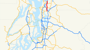
length_mi=11.92
length_round=2
length_ref=cite web |author=Washington State Department of Transportation |url=http://www.wsdot.wa.gov/mapsdata/tdo/PDF_and_ZIP_Files/HwyLog2006.pdf |title=State Highway Log, 2006 |accessdate=2008-09-24 |format=pdf]
established=1964cite web |url=http://apps.leg.wa.gov/RCW/default.aspx?cite=47.17.745 |title=RCW 47.17.745: State Route 527 |author=Washington State Legislature |accessdate=2008-09-25]
direction_a=South
terminus_a=jct|state=WA|SR|522 in Bothell
junction=jct|state=WA|I|405 in Bothell jct|state=WA|SR|524 in Bothell jct|state=WA|SR|96 in Everett
direction_b=North
terminus_b=jct|state=WA|I|5|SR|99|SR|526 in Everett
spur_type=I
spur_of=5
previous_type=SR
previous_route=526
next_type=SR
next_route=528State Route 527 (SR 527, also known as the Bothell – Everett Highwaycite news |title=WSDOT Detours Bothell – Everett Highway Near Silver Lake This Weekend |url=http://www.wsdot.wa.gov/News/2005/04/Apr_25_05_SR527Detour.htm |publisher=
Washington State Department of Transportation |date=2005-04-27 |accessdate=2008-10-07] ) is a state highway in King and Snohomish counties, of the U.S. state ofWashington . It extends convert|11.92|mi|km|2 from SR 522 in the city ofBothell, Washington , north to an interchange with Interstate 5 (I-5), SR 99, and SR 526 inEverett, Washington . SR 527 intersects I-405, SR 524, and SR 96 before ending in Everett. The route serves as a connector between Bothell, Everett, and Mill Creek.The highway itself did not fully open until October 17, 1969, and since its opening, it has become increasingly busy, with about 57,000 motorists using the highway at its interchange with I-405 in 2004. A large construction project that started in 1991, ended in 2006 after widening the highway and put up
sound wall s along the highway.Route description
SR 527 runs convert|11.92|mi|km|2 north from SR 522 in the city of Bothell, through an interchange with I-5, and ends at SR 99, and SR 526 in Everett. The route links the cities of Bothell, Everett, and Mill Creek, and intersects three highways: I-405, SR 524, and SR 96.cite map |publisher=
Google Maps |title=State Route 527 Overview Map |url=http://maps.google.com/maps?f=d&saddr=Main+St&daddr=47.837703,-122.213459+to:19th+Ave+SE%2FWA-527+to:Boeing+Fwy%2FWA-527&hl=en&geocode=FWLC2AIdWEO3-A%3B%3BFRSq2gId9kW3-A%3BFaIx2wIdE0C3-A&mra=dpe&mrcr=0&mrsp=1&sz=13&via=1,2&sll=47.842197,-122.234917&sspn=0.03491,0.071411&ie=UTF8&ll=47.86201,-122.202301&spn=0.279172,0.571289&z=10 |year=2008 |cartography=NATVEQ |accessdate=2008-09-25] [cite map |publisher=Rand McNally |title=The Road Atlas |year=2008 |page=108, 110 |section=E7 (108), A9 / B9 (110) |isbn=0528939610] [cite map |publisher=G.M. Johnson |title=Everett, Edmonds, Lynnwood |url=http://store.maplink.com/map.aspx?nav=MS&cid=10056,10078&pid=522923 |edition=2007 |year=2007 |series=City Street Maps |accessdate=2008-09-26] WSDOT has found that about 46,000 motorists utilize the road daily at I-405 based onaverage annual daily traffic (AADT) data.cite web |url=http://www.wsdot.wa.gov/mapsdata/tdo/PDF_and_ZIP_Files/Annual_Traffic_Report_2007.pdf |title=Washington Annual Average Daily Traffic Data |author=Washington State Department of Transportation |year=2007 |accessdate=2008-09-26]SR 527 starts at SR 522 in Bothell, about convert|1.3|mi|km from the SR 522/I-405 interchange. [cite map |publisher=Google Maps |title=SR 522 Map (SR 527 to I-405) |url=http://maps.google.com/maps?f=d&saddr=WA-522%2FWoodinville+Dr&daddr=47.758599,-122.183976&hl=en&geocode=FRzC2AIdzEK3-A%3B&mra=dme&mrcr=0&mrsp=1&sz=15&sll=47.760243,-122.186379&sspn=0.008741,0.017853&ie=UTF8&ll=47.757387,-122.196121&spn=0.017484,0.035706&z=14 |year=2008 |cartography=NATVEQ |accessdate=2008-09-27] From the intersection, SR 527 runs northwest to Canyon Park Place, where after intersecting 228th Street SE, the highway has a
partial cloverleaf interchange with I-405. [cite map |publisher=Google Maps |title=SR 527 Map (SR 522 to I-405) |url=http://maps.google.com/maps?f=d&saddr=Main+St&daddr=47.795081,-122.214081&hl=en&geocode=FWLC2AIdWEO3-A%3B&mra=mi&mrsp=1&sz=16&sll=47.794534,-122.214339&sspn=0.004368,0.008926&ie=UTF8&ll=47.780174,-122.216377&spn=0.069903,0.142822&z=12 |year=2008 |cartography=NATVEQ |accessdate=2008-09-27] From the interchange, the road heads northeast to Thrashers Corner, where SR 527 intersects SR 524 before moving on to pass Kennard Corner, Silver Creek Park, North Creek County Park, and Mays Pond Park. After passing the parks, the highway intersects 164th Street SE, a major arterial road, in Mill Creek. [cite map |publisher=Google Maps |title=SR 527 Map (I-405 to Mill Creek) |url=http://maps.google.com/maps?f=d&saddr=19th+Ave+SE%2FWA-527&daddr=47.84957,-122.217386&hl=en&geocode=FYhL2QIdQCm3-A%3B&mra=mi&mrsp=1&sz=16&sll=47.850189,-122.217493&sspn=0.004363,0.008926&ie=UTF8&ll=47.82399,-122.212257&spn=0.069845,0.142822&z=12 |year=2008 |cartography=NATVEQ |accessdate=2008-09-27]After the intersection with 164th Street SE, the road goes north, past Mill Creek's town center and the Mill Creek Library and Library Park before intersecting a connector to SR 96 westbound. [cite map |publisher=Google Maps |title=SR 527 Map (Mill Creek to SR 96) |url=http://maps.google.com/maps?f=d&saddr=WA-527&daddr=47.878196,-122.207097&hl=en&geocode=FVEg2gIdRRy3-A%3B&mra=mi&mrsp=1,0&sz=17&sll=47.878635,-122.207558&sspn=0.00218,0.004463&ie=UTF8&ll=47.86558,-122.217064&spn=0.034894,0.071411&z=13 |year=2008 |cartography=NATVEQ |accessdate=2008-09-27] After the following the connector, SR 527 intersects SR 96 before traveling on the eastern shore of
Silver Lake and intersecting 112th Street SE, which goes west to the South Everett Freeway Station which was completed in 2008. [cite web |url=http://www.wsdot.wa.gov/projects/i5/southeverett/ |title=I-5 - South Everett Freeway Station / 112th Street SE Project |author=Washington State Department of Transportation |accessdate=2008-09-27] [cite web |url=http://www.soundtransit.org/x1877.xml |title=South Everett Freeway Station Project |author=Sound Transit |accessdate=2008-09-27] From the intersection, the route then heads north to the EastmountPark and Ride , where it goes northwest to an interchange with I-5 and then to an intersection with SR 99, SR 526, and Broadway, where it terminates. [cite map |publisher=Google Maps |title=SR 527 Map (SR 96 to I-5 / SR 99 / SR 526 Interchange) |url=http://maps.google.com/maps?f=d&saddr=WA-527&daddr=47.919578,-122.208309&hl=en&geocode=FS6Q2gIdtkS3-A%3B&mra=mi&mrsp=1&sz=17&sll=47.919463,-122.207944&sspn=0.002179,0.004463&ie=UTF8&ll=47.901844,-122.206764&spn=0.06974,0.142822&z=12 |year=2008 |cartography=NATVEQ |accessdate=2008-09-27] The road continues west from the intersection as SR 526, also known as theBoeing Freeway , and goes west to theBoeing Everett Factory ,Paine Field , and goes towardsMukilteo, Washington . [cite map |publisher=Google Maps |title=State Route 526 Overview Map |url=http://maps.google.com/maps?f=d&saddr=47.919678,-122.208652&daddr=84th+St+SW&hl=en&geocode=%3BFVA72wIdANm1-A&mra=dme&mrcr=0&mrsp=0&sz=13&sll=47.92313,-122.215691&sspn=0.034856,0.071411&ie=UTF8&ll=47.922554,-122.254486&spn=0.069712,0.142822&z=12 |year=2008 |cartography=NATVEQ |accessdate=2008-09-27] SR 99 goes south from the intersection to theEverett Mall ,Seattle , and Fife. [cite map |publisher=Google Maps |title=State Route 99 Overview Map |url=http://maps.google.com/maps?f=d&saddr=Broadway&daddr=Evergreen+Way%2FWA-99+to:WA-99+to:Aurora+Ave+N%2FWA-99+to:Aurora+Ave+N%2FWA-99+to:S+Michigan+St+to:47.533893,-122.33139+to:16th+Ave+S+to:Tukwila+International+Blvd%2FWA-99+to:WA-509%2FWA-99+to:WA-99+to:54th+Ave+E&hl=en&geocode=Fcgx2wId3j-3-A%3BFYrt2gIdYKq2-A%3BFTYp2gIdiPa1-A%3BFYTr2AIdBCa1-A%3BFe6W1wIdmiu1-A%3BFcp71QIdsGW1-A%3B%3BFY411QIdIKC1-A%3BFYRt1AIdnBm2-A%3BFXFn0gIdOam1-A%3BFWZ60QIdpoO1-A%3BFW3W0AId1vq0-A&mra=dpe&mrcr=0&mrsp=6&sz=10&via=1,2,3,4,5,6,7,8,9,10&sll=47.52091,-122.358856&sspn=0.281004,0.571289&ie=UTF8&ll=47.62838,-122.310791&spn=1.121683,2.285156&z=8 |year=2008 |cartography=NATVEQ |accessdate=2008-09-27] An extension of SR 99, Broadway, goes north from the intersection into Downtown Everett. [cite map |publisher=Google Maps |title=Broadway Overview Map |url=http://maps.google.com/maps?f=d&saddr=Boeing+Fwy+W%2FWA-526+W&daddr=47.944522,-122.200241+to:N+Broadway&hl=en&geocode=Fcgx2wId3j-3-A%3B%3BFWmX3AIdT4W3-A&mra=dpe&mrcr=0&mrsp=1&sz=13&via=1&sll=47.956249,-122.19595&sspn=0.034833,0.071411&ie=UTF8&ll=47.969698,-122.207794&spn=0.139296,0.285645&z=11 |year=2008 |cartography=NATVEQ |accessdate=2008-09-27]History
Before the Primary and Secondary system, SR 527 in 1923 was part of State Road 1, which later became U.S. Route 99 (US 99).cite book |author=Washington State Legislature |title=Session Laws of the State of Washington |url=http://books.google.com/books?id=G784AAAAIAAJ&pgis=1 |accessdate=2008-09-27 |edition=1923 edition |series=Session Laws of the State of Washington |year=1923 |publisher=Washington State Legislature |location=Olympia, Washington |chapter=185] Later, in 1937, the route became part of
Secondary State Highway 2A (SSH 2A),cite book |author=Washington State Legislature |title=Session Laws of the State of Washington |url=http://books.google.com/books?id=dcQ4AAAAIAAJ&q=%22ESTABLISHMENT+OF+PRIMARY+STATE+HIGHWAYS.%22+pacific&pgis=1#search |accessdate=2008-09-27 |edition=1937 edition |series=Session Laws of the State of Washington |year=1937 |publisher=Washington State Legislature |location=Olympia, Washington |chapter=190] but was later removed in 1943,cite book |author=Washington State Legislature |title=Session Laws of the State of Washington |url=http://books.google.com/books?id=bcY4AAAAIAAJ&pgis=1 |accessdate=2008-08-10 |edition=1943 edition |series=Session Laws of the State of Washington |year=1943 |publisher=Washington State Legislature |location=Olympia, Washington|chapter=207] and readded as SSH 2J in 1957cite book |author=Washington State Legislature |title=Session Laws of the State of Washington |url=http://books.google.com/books?id=Zck4AAAAIAAJ&pgis=1 |accessdate=2008-08-10 |edition=1957 edition |series=Session Laws of the State of Washington |year=1957 |publisher=Washington State Legislature |location=Olympia, Washington |chapter=172] It went from PSH 2 BO (Bothell branch) in Bothell to SSH 1I and US 99 in Everett. SSH 2J became state highway 527 in 1964 during the 1964 highway renumbering, in which theWashington State Department of Transportation (WSDOT) replaced the previous system of Primary and Secondary Highways with a new system called State Routes, which is still in use today.SR 527 officially opened on October 17, 1969,cite book |author=David A. Cameron |coauthors=Lynne Grimes, Jane Wyatt |title=Snohomish County: An Illustrated History |year=2005 |publisher=Kelcema Books |isbn=0-9766700-0-3 |pages=p. 338 |chapter=Chapter 11: 1965-2004 |location=Index, Washington] but eventually, the highway became overcrowded, with about 57,000 motorists using the road in 2004 at the I-405 interchange. To alleviate congestion, an expansion project for SR 527 started in 1991 was completed in 2006. [cite web |url=http://www.wsdot.wa.gov/projects/sr527/corridorwiden/ |title=SR 527 - Corridor Improvements |publisher=Washington State Department of Transportation |accessdate=2008-09-26] The first stage of the project involved widening the roadway to five–seven lanes between 228th Street SE and SR 524 and minor improvements at its interchange with I-405. The second stage widened the roadway to five lanes between SR 524 and 164th Street, while the third widened the road between 164th Street SE and SR 96.cite web |url=http://www.wsdot.wa.gov/projects/sr527/corridorwiden/164thse_132ndse/ |title=SR 527 - Corridor Widening - 164th Street SE to 132nd Street SE (SR 96) |publisher=Washington State Department of Transportation |accessdate=2008-09-26] The fourth and most complex stage widened the road between SR 96 and 112th Street SE.cite web |url=http://www.wsdot.wa.gov/Projects/SR527/CorridorWiden/132ndSE_112thSE |title=SR 527 - Corridor Widening - 132nd Street SE (SR 96) to 112th Street SE |publisher=Washington State Department of Transportation |accessdate=2008-09-26] This stage involved expanding the SR 527/SR 96 intersection dramatically and raising the roadway near Silver Lake, along with numerous pedestrian and aesthetic improvements. [cite web |url=http://www.environment.fhwa.dot.gov/strmlng/searchresults.asp?keyword=&StateSelect=Washington&CategorySelect=all&startrow=1&ResultsSelect=5 |title=Environmental Review Toolkit - Streamlining and Stewardship - Search Results (see #5) |author=
Federal Highway Administration |accessdate=2008-09-27]Major intersections
References
External links
* [http://www.angelfire.com/wa2/hwysofwastate/sr527.html Highways of Washington State]
* [http://www.wsdot.wa.gov/projects/sr527/corridorwiden/ Washington State Department of Transportation: SR 527 - Corridor Improvements]
* [http://www.wsdot.wa.gov/traffic/seattle/sr527_164th.htm Traffic camera for SR 527 endash 164th Street Intersection (WSDOT)]
* [http://www.wsdot.wa.gov/Traffic/seattle/I405_SR527_interchange.htm Traffic camera for SR 527 endash I-405 Interchange (WSDOT)]

Wikimedia Foundation. 2010.