Washington State Route 513

Washington State Route 513

infobox WA State Route
type=WA
route=513
sec=695
parent=5
parent_type=Interstate
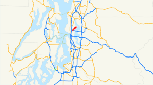


length_mi=3.35
length_ref=cite web|author=Washington State Department of Transportation|url=http://www.wsdot.wa.gov/mapsdata/tdo/PDF_and_ZIP_Files/HwyLog2006.pdf|title=State Highway Log, 2006|accessdate=2007-04-22]
length_round=2
formed=1992 (Original route 1964)
dir1=South
dir2=North
from=
to=NE 65th Street in Seattle
previous_type=WA
previous_route=512
next_type=WA
next_route=515

State Route 513 is a state highway entirely within Seattle, Washington, 3.5 miles in length. It is signed once, at NE 45th Street and Sand Point Way NE.

SR 513 begins at the intersection of Montlake Boulevard E., E. Montlake Place E., and E. Lake Washington Boulevard in Montlake, which is an interchange with State Route 520. From there, it follows Montlake Boulevard north across the Montlake Bridge and through the University of Washington campus to N.E. 45th Street. At this point, it follows 45th Street east past University Village to its intersection with Sand Point Way N.E. It then follows Sand Point Way northeast to the entrance to Magnuson Park at N.E. 65th Street in Sand Point.

It originally ran from the north city limits to Downtown via Lake City, Sand Point, Montlake, the Central District, and First Hill. In 1971, its southern end was fixed at Montlake, and in 1992 its northern end was fixed at Sand Point. It was originally known as Secondary State Highway 1J [http://www.angelfire.com/wa2/hwysofwastate/ssh001j.html (Washington State Highways)] after it was established in 1937.

References

External links

* [http://www.angelfire.com/wa2/hwysofwastate/sr513.html Washington State Highways]


Wikimedia Foundation. 2010.

Игры ⚽ Поможем решить контрольную работу

Look at other dictionaries:

  • Washington State Route 525 — State Route 525 Whidbey Scenic Isle Way …   Wikipedia

  • Washington State Route 542 — State Route 542 Route information …   Wikipedia

  • Washington State Route 515 — infobox WA State Route type=WA route=515 sec=705 parent=5 parent type=Interstate length mi=7.86 length ref=cite web|author=Washington State Department of Transportation|url=http://www.wsdot.wa.gov/mapsdata/tdo/PDF and ZIP… …   Wikipedia

  • Washington State Route 514 — Infobox WA State Route|type=WA|route=514|sec=|length mi=|parent type=Interstate|parent=5 length ref= [cite web|author=Washington State Department of Transportation|url=http://www.wsdot.wa.gov/mapsdata/tdo/PDF and ZIP… …   Wikipedia

  • Washington State Route 512 — infobox WA State Route type=WA route=512 sec=690 parent=5 parent type=Interstate length mi=12.06 length ref= length round=2 formed=1964 dir1=West dir2=East from= junction= to= previous type=WA previous route=510 next type=WA next route=513State… …   Wikipedia

  • County Route 513 (New Jersey) — County Route 513 Route information Length: 66.83 mi[1] (107.55 km) …   Wikipedia

  • New York State Route 85 — NYS Route 85 Route information Maintained by NYSDOT Length: 26.49 mi[ …   Wikipedia

  • New York State Route 43 — NY 43 redirects here. NY 43 may also refer to New York s 43rd congressional district. NYS Route 43 Map of the Albany area with NY 43 highlighted in red …   Wikipedia

  • New York State Route 96 — This article is about the current alignment of NY 96. For the former alignment of NY 96 in Rensselaer County, see New York State Route 96 (1930 – early 1940s). NYS Route 96 Map of the F …   Wikipedia

  • California State Route 111 — Karte …   Deutsch Wikipedia

Share the article and excerpts

Direct link
Do a right-click on the link above
and select “Copy Link”