- Washington State Route 539
infobox WA State Route
type=State
route=539
sec=785
parent=5
parent_type=Interstate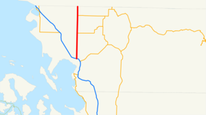
length_mi=15.16
length_ref= [http://www.wsdot.wa.gov/mapsdata/tdo/PDF_and_ZIP_Files/HwyLog2005B.pdf State Highway Log] , Washington State Department of Transportation, 2005 B]
length_round=2
formed=1969
dir1=South
dir2=North
from=
junction=
to=
previous_type=WA
previous_route=538
next_type=WA
next_route=542State Route 539 (SR 539), or the Guide Meridian Road (known as Meridian in
Bellingham, Washington and the Guide inLynden, Washington ), is astate highway inWashington ,U.S.A. It runs for 15.16 miles from Bellingham in the south to theU.S.-Canadian border at Lynden-Langley in the north.Route description
SR 539 begins at Exit 256 of Interstate 5 just south of the Bellis Fair Mall, approximately four miles north of downtown Bellingham. From there it proceeds due north to the Canadian border between
Lynden, Washington and the Township of Langley, British Columbia.Once past the Bellis Fair Mall immediately north of the I-5 interchange, SR 539 continues through the shopping centers of the northern outskirts of Bellingham; Whatcom Community College and the Cordata Business Park are also nearby. Shortly after leaving this area, the road narrows from the four to six lane thoroughfare to the two-lane road it remains all the way to the border.
North of Bellingham, it passes through the small town of Laurel, which contains Meridian High School. It then passes over Wiser Lake and the
Nooksack River , before arriving in Lynden, home to a municipal airport.The entire route from I-5 to the border is perfectly straight north-south. It serves mostly traffic from Bellingham (and the I-5 freeway) to the city of Lynden, although it also serves the Everson-Nooksack-Sumas area via State Route 544. It also provides an alternate route into
Canada when the border crossings at Blaine on I-5 and State Route 543 are backed up.The Guide meridian is currently under an expansion project that will transform it from a two lane highway to a four lane highway. The project is being completed in two phases. The first phase is from Horton Road to Ten Mile road. Along with the wider roadway the project will install new signals at Smith, Axton and Laurel Road intersections. It will also replace both the Four Mile Creek and Ten Mile Creek Bridges with wider, safer bridges. Construction of this segment was started in June 2007, the construction company carrying out the project is IMCO General Construction of Bellingham. The total cost of this segment is $39.9 million and is being funded by the Washington State DOT. This phase is slated to be finished Fall 2008.
The second phase is from Ten Mile road to Badger road. The project will create a four lane highway from Ten Mile road to Badger road. It will also build four new roundabouts at key intersections to further help improve safety [http://www.wsdot.wa.gov/Projects/SR539/TenMileBorder/] , SR 539 - Ten Mile Road to Badger Road Widening] . They will also widen or replace the Wiser Lake, Fishtrap Creek and Floodway Bridges. In Summer 2007 the crews will begin to move utilites from the roadway. In Fall 2007 the the DOT will finish buying property, and construction is slated to start in Spring 2008. The DOT has awarded the construction contact to Max J. Kuney Company. They have set aside $101,635,000 for this segment of the project.
History
*Prior to the 1964 state highway renumbering, SR 539 was known as SSH (Secondary State Highway) 1-B. (The I-5 corridor at the time was known as Primary State Highway 1.) U.S. Route 99 came into being in 1926 with the rest of the original U.S. Highways, and was signed concurrently with PSH-1 until 1964. In 1954, SSH-1-B was designated as U.S. Route 99 Alternate. During the 1964 renumbering, the PSH-1 and SSH-1-B designations were removed. Then in 1969, U.S. 99 was decommissioned in the state of Washington, as was Alt. U.S. 99, and Alt. U.S. 99 was replaced by SR 539.
*The routing of SSH-1-B/Alt. U.S. 99 presumably continued south on Meridian Street past what is now I-5, then down either Broadway or Girard Street in downtown Bellingham to connect with U.S. 99/PSH-1, which at the time ran on Holly Street, Prospect Street, and Dupont Street in downtown Bellingham.
References
External links
* [http://www.angelfire.com/wa2/hwysofwastate/sr539.html State Route 539]

Wikimedia Foundation. 2010.