- Blaine, Washington
Infobox Settlement
official_name = City of Blaine
settlement_type =City
nickname = ThePeace Arch City
motto = Blaine is Where America Begins
imagesize =
image_caption =
image_
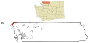
mapsize = 250x200px
map_caption = Location in the state ofWashington
mapsize1 =
map_caption1 =
subdivision_type = Country
subdivision_type1 = State
subdivision_type2 = County
subdivision_name =United States
subdivision_name1 =Washington
subdivision_name2 = Whatcom
government_type =
leader_title =
leader_name =
leader_title1 =
leader_name1 =
leader_title2 =
leader_name2 =
leader_title3 =
leader_name3 =
established_title = Incorporated
established_date =May 20 ,1890
area_magnitude =
area_total_km2 = 22.0
area_total_sq_mi = 8.5
area_land_km2 = 14.3
area_land_sq_mi = 5.5
area_water_km2 = 7.6
area_water_sq_mi = 3.0
area_water_percent =
area_urban_km2 =
area_urban_sq_mi =
area_metro_km2 =
area_metro_sq_mi =
population_as_of =2008
population_note =
population_total = 4650
population_density_km2 = 325.2
population_density_sq_mi = 845.5
population_metro =
population_density_metro_km2 =
population_density_metro_sq_mi =
population_urban =
timezone = PST
utc_offset = -8
timezone_DST = PDT
utc_offset_DST = -7
latd = 48 |latm = 59 |lats = 17 |latNS = N
longd = 122 |longm = 44 |longs = 37 |longEW = W
elevation_m = 16
elevation_ft = 52
postal_code_type =ZIP code s
postal_code = 98230 (home delivery) and 98231 (post office boxes)
website = http://www.cityofblaine.com
area_code = 360
blank_name = FIPS code
blank_info = 53-06505GR|2
blank1_name = GNIS feature ID
blank1_info = 1512014GR|3
footnotes =Blaine is a city in Whatcom County,
Washington ,United States . The city's northern boundary is the Canadian border. Blaine is the shared home of thePeace Arch international monument.History
Blaine was officially incorporated on
May 20 ,1890 , and was named afterJames G. Blaine (1830–1893), who was a U.S. senator from the state ofMaine ,Secretary of State , and, in1884 , the unsuccessful Republican presidential candidate.Blaine, Washington, was first settled in the mid 1800s by pioneers who established the town as a seaport for the west coast logging and fishing industries, and as a jumping off point for prospectors heading to
British Columbia 's gold fields. In its heyday Blaine was home to over 10,000 people, twice today’s population. The World's largestsalmon cannery was operated by the Alaska Packer's Association for decades in Blaine: the cannery site has been converted to a waterfront destination resort onSemiahmoo Spit . Severalsaw mill s once operated on Blaine's waterfront, and much of the lumber was transported from its wharves and docks to help rebuildSan Francisco following the 1906 fire there. The forests were soon logged, but Blaine's fishing industry remained strong and robust into the second half of the twentieth century. Into the 1970s Blaine was home to hundreds of commercial purse seiners andgillnet ters plying the waters between Washington State and southeastAlaska . Blaine's two large marinas are still home to hundreds of recreational sailboats and yachts, and a small fleet of determined local fishers provide visitors with dockside sale of fresh salmon, crab and oysters. Nature lovers have always appreciated Blaine's coastal location, its accessible bike and walking trails, and view of mountains and water. Birdwatchers across the continent have discovered the area's high content of migratory birds and waterfowl: Blaine's Drayton Harbor, Semiahmoo Spit and Boundary Bay are ranked as ImportantBirding Areas by theAudubon Society .The Cains are the most notable and historical family in Blaine's short history, credited with its founding and achievements. At one time owning most of present day Blaine, the Cain brothers erected the biggest store north of Seattle, a lumber and shingle mill, a hotel (largest in the state at the time), the first public wharf, and donated large public tracts of land. At least one local family are direct descendents from these earlier pioneers.
Canadian Border
International border intrigue has always been a part of Blaine's ambience. Smuggling became an underground industry there in 1919 with the passage of the
Volstead Act banning liquor sale and use in the United States.Rum-running and border jumping thrived along Blaine's shared coastline withBritish Columbia , due in part to the area's largest whiskey still being located on nearby Texada Island. This continued until Prohibition was repealed in 1933 (coincidentally the US Congressional law which re-legalized alcohol is named theBlaine Act ). In subsequent decades, the situation was reversed due to restrictive drinking and entertainment laws in British Columbia, notably a ban on Sunday drinking, which led to Blaine and its sister border-towns atPoint Roberts and Sumas booming with taverns and adult entertainment of various kinds. Even after BC liquor laws were liberalized, more or less, in the 1970s, Blaine and the other border towns boomed in the retail sector for goods such as gasoline, dairy products and even clothing outlets as currency exchange rates changed in favour of the US dollar.In the 1990’s smuggling again reached a zenith as criminals in neighboring British Columbia became major exporters of high grade
marijuana . More punitive U.S. drug laws provided a haven to cannabis 'grow operations'. As the production of 'BC Bud' coalesced into competing groups of criminal organizations across BC, a sometimes dangerous game of cat and mouse played out along Blaine's border with Canada. Smugglers used every technique from backpacks to helicopter aerial drops to push tons of the marijuana crop into the US, while a growing phalanx of local, state, provincial and federal law enforcement from both sides of the border sought ways to stem the tide. Smuggling of drugs, weapons, and money, and human trafficking continues in the area. However, following the terrorist attacks of 2001, the addition of hundreds of federal agents and millions of dollars in enforcement technology have supposedly pushed more of the smuggling activity away from Blaine and into the rugged interior of Washington.With its location at the intersection of an international border, a major interstate freeway, and the Pacific Ocean, Blaine is frequently in the news. The Peace Arch is occasionally still used as a focal point for peaceful demonstrations and debate, such as the annual setting of crosses for each American killed so far in the Iraqi War, but most of the people who visit or pass by the Park each year remember it for its beauty and peaceful shoreline setting (although the beach is not officially accessible from the park). One innovative feature that has never been abrogated even during the days after 9/11 is that people entering the park from either side may go to the opposite park boundary without going through customs, making the park a place of international mingling and, frequently, weddings where guests do not have to worry about clearing customs first. Recently a group of Blaine community members unsuccessfully solicited city council support to formalize a sister-city relationship with
Pugwash, Nova Scotia . That effort is continuing.Currently, both the US and Canadian customs agencies are re-building their facilities on either side of Peace Arch Park, hopefully in time for the Winter Olympic Games set for Vancouver in February 2010.
Peace Arch Park is located in Blaine at the US Canadian border, and the Canadian city ofSurrey, British Columbia is adjacent to Blaine on the north side of the international boundary. The Park straddles the U.S./Canada border, allowing visitors the experience of strolling to and from between countries amid flowers, ponds, and various works of art. The Peace Arch monument, located in the Park, symbolizes lasting peace and amity between the U.S. and Canada.Geography
According to the
United States Census Bureau , the city has a total area of 8.5square mile s (22.0km² ), of which, 5.5 square miles (14.3 km²) of it is land and 3.0 square miles (7.6 km²) of it (34.57%) is water.Blaine's motto is "Where America Begins": the community is also known as "The Gateway to the Pacific Northwest", and the "Peace Arch City. All these phrases are commentaries on Blaine's unique locale. It lies at the northernmost point of the North-South U.S. Interstate 5 and next to Drayton Harbor andBoundary Bay (the adjoining waterway is often referred to asSemiahmoo Bay ).Blaine has a small airport, popular with light
aircraft owners for its low fuel prices and because it has less fog than other nearby airports. The runway measures 2539 x 40 ft. / 774 x 12 m. The Blaine city government operates the automated fuel pumps. In the spring of 2006 the city government removed several tall trees south of the runway as a safety precaution. Link — http://www.airnav.com/airport/4W6 In 2007 city council voted to direct staff to to close the airport facility before the end of 2008. The land upon which the airport rests is undergoing master planning for a mixed use development.Demographics
As of the
census GR|2 of 2000, there were 3,770 people, 1,496 households, and 1,036 families residing in the city. Thepopulation density was 680.4 people per square mile (262.7/km²). There were 1,737 housing units at an average density of 313.5/sq mi (121.1/km²). The racial makeup of the city was 87.72% White, 1.19% African American, 1.14% Native American, 4.19% Asian, 0.66% Pacific Islander, 1.33% from other races, and 3.77% from two or more races. Hispanic or Latino of any race were 4.35% of the population.There were 1,496 households out of which 32.1% had children under the age of 18 living with them, 52.9% were married couples living together, 12.4% had a female householder with no husband present, and 30.7% were non-families. 25.5% of all households were made up of individuals and 10.1% had someone living alone who was 65 years of age or older. The average household size was 2.48 and the average family size was 2.96.
In the city the population was spread out with 26.5% under the age of 18, 6.9% from 18 to 24, 26.4% from 25 to 44, 25.7% from 45 to 64, and 14.4% who were 65 years of age or older. The median age was 39 years. For every 100 females there were 94.5 males. For every 100 females age 18 and over, there were 90.2 males.
The median income for a household in the city was $36,900, and the median income for a family was $45,056. Males had a median income of $36,381 versus $23,561 for females. The
per capita income for the city was $20,333. About 10.2% of families and 15.5% of the population were below thepoverty line , including 16.6% of those under age 18 and 8.3% of those age 65 or over.Economy
Much of Blaine's economy is based on trade across the Canadian border. The eastern side of the city accommodates a number of import/export warehouses, freight and courier services and gas stations serving long haul
cargo trucks . The Customs and Border Protection branch of theDepartment of Homeland Security operates two border inspection stations in Blaine. The Blaine Sector Headquarters of the US Border Patrol employs hundreds of federal law enforcement officers and support staff in the community.Blaine also includes a number of manufacturing companies, including Nature's Path Cereal plant and Totally Chocolate.
The
Port of Bellingham operates a largemarina 1 km south of the border, serving a variety of pleasure craft and fishing vessels.School district
Blaine School District #503 serves a population which extends to the south end of nearbyBirch Bay , well beyond the City limits of Blaine. The largest share of school services is consolidated on a large (quarter mile square) campus in central Blaine. Approximately 2,500 students of all grades (K-12) attend school in facilities which separately house K-2, 3-5, 6-8, and 9-12th grades respectively. Students from the small nearby USexclave ofPoint Roberts, Washington above 3rd grade are also bussed to Blaine to attend school. The school district enjoys very strong community support, and in return provides an array of award-winning educational and child development services.Fact|date=July 2008 The main campus is home to a state-of-the-art tiered-seating Performing Arts Center and sports facilities for all team sports.All the athletes in the 2-A Whatcom county League who have turned pro have a connection with Blaine, either having played there, coached there or taught there. Two years agowhen infielder Joey Paciorek was drafted by the Milwaukee Brewers where his father Jim once played.
Blaine High School is also thealma mater ofLuke Ridnour , apoint guard for the NBA'sSeattle SuperSonics .Scott Gomez of theNew York Rangers (NHL ) attended Blaine High School for one year while playing hockey just across the Canadian border for the South Surrey Eagles of the Tier II Junior "A"British Columbia Hockey League .Trivia
* The Interstate 5 freeway extends from the US/Mexican border at San Diego, northward to Canada, and terminates in Blaine at the city's northern border.
* A house on B Street in Blaine is famous for having a four-story basement that goes nearly 50 feet underground.
* Blaine is the home of the "Vigil," a bronze sculpture by Bob McDermott that shows a fisher's family waiting patiently for him to return from the sea. The $100,000 piece is located on the H Street Plaza in the middle of town.
References
External links
* [http://www.cityofblaine.com City of Blaine]
* [http://www.blaine.net Blaine Washington Community Web Portal]
* [http://www.bellingham.com Bellingham-Whatcom Chamber of Commerce & Industry]
* [http://www.thenorthernlight.com/ Blaine Community Newspaper]
* [http://www.blainechamber.com/ Blaine Community Chamber of Commerce]
* [http://www.wcls.org/ Whatcom County Library System, serving Blaine and surrounding areas]
* [http://content.lib.washington.edu/cdm4/item_viewer.php?CISOROOT=/wastate&CISOPTR=1177&CISOBOX=1&REC=19 Fishboats in Blaine Harbour, 1954, U.Wash Digital Collections]urrounding Municipalities
Geographic Location (8-way)
Centre = Blaine
North = Surrey
(British Columbia, Canada)
Northeast = Langley
(British Columbia, Canada)
East = Sumas
Southeast = Lynden
South = Birch Bay
Southwest =
West = Point Roberts, "Boundary Bay "
Northwest = Delta, Surrey, White Rock (British Columbia, Canada), "Boundary Bay ", "Semiahmoo Bay "

Wikimedia Foundation. 2010.