- White Rock, British Columbia
Infobox Settlement
official_name = City of White Rock
other_name =
native_name =
nickname =
settlement_type =
motto =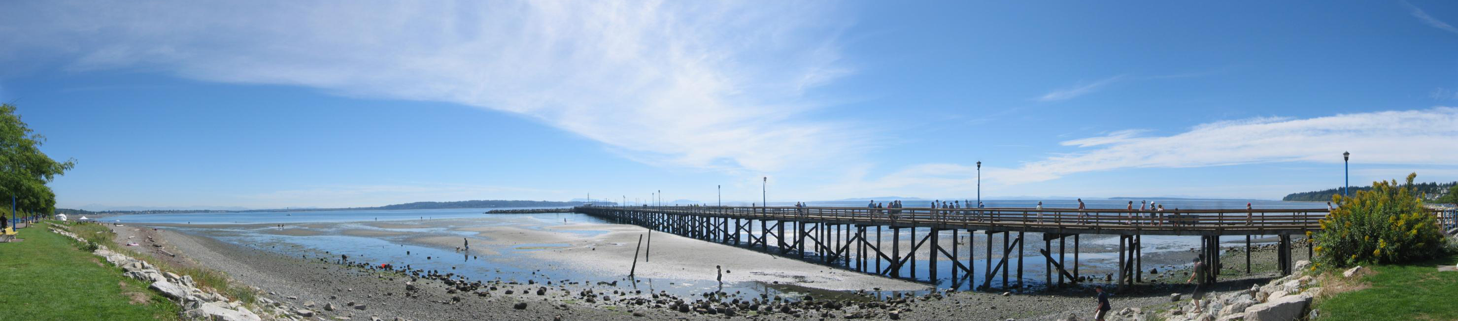
imagesize =
image_caption = A panorama of the promenade and pier.
flag_size =
image_
seal_size =
image_shield = Whiterock-coatofarms.gif
shield_size =
city_logo =
citylogo_size =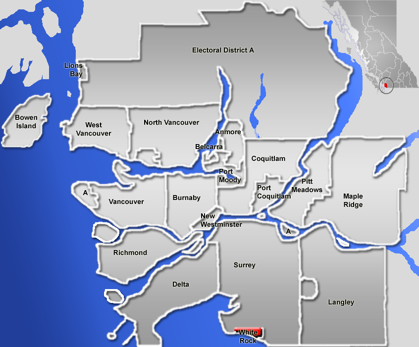
mapsize =
map_caption =
mapsize1 =
map_caption1 =
image_dot_
dot_mapsize =
dot_map_caption =
dot_x = |dot_y =
pushpin_
pushpin_label_position =
pushpin_map_caption =
pushpin_mapsize =
subdivision_type = Country
subdivision_name = CAN
subdivision_type1 = Province
subdivision_name1 = BC
subdivision_type2 = Regional District
subdivision_name2 =Metro Vancouver
subdivision_type3 =
subdivision_name3 =
subdivision_type4 =
subdivision_name4 =
government_footnotes =
government_type =
leader_title = Mayor
leader_name = Judy Forster
leader_title1 = Governing Body
leader_name1 = White Rock City Council
leader_title2 = MP
leader_name2 =Russ Hiebert (Conservatives)
leader_title3 = MLA
leader_name3 = Gordon Hogg (BC Liberals)
leader_title4 =
leader_name4 =
established_title = Incorporated
established_date = April 15, 1957
established_title2 =
established_date2 =
established_title3 =
established_date3 =
area_magnitude =
unit_pref =
area_footnotes =
area_total_km2 = 5.28
area_land_km2 =
area_water_km2 =
area_total_sq_mi =
area_land_sq_mi =
area_water_sq_mi =
area_water_percent =
area_urban_km2 =
area_urban_sq_mi =
area_metro_km2 =
area_metro_sq_mi =
area_blank1_title =
area_blank1_km2 =
area_blank1_sq_mi =
population_as_of = 2006
population_footnotes = [Statistics Canada (2006 Census). [http://www12.statcan.ca/english/census06/data/profiles/community/Details/Page.cfm?Lang=E&Geo1=CSD&Code1=5915007&Geo2=PR&Code2=59&Data=Count&SearchText=white%20rock&SearchType=Begins&SearchPR=01&B1=All&Custom= White Rock Community Profile] ]
population_note =
population_total = 18755
population_density_km2 =
population_density_sq_mi =
population_metro =
population_density_metro_km2 =
population_density_metro_sq_mi =
population_urban =
population_density_urban_km2 =
population_density_urban_sq_mi =
population_blank1_title =
population_blank1 =
population_density_blank1_km2 =
population_density_blank1_sq_mi =
timezone =Pacific Time Zone
utc_offset = -8
timezone_DST = Pacific Daylight Time
utc_offset_DST = -7
latd= 49|latm= 1|lats= 11.7|latNS=N
longd= 122|longm= 48|longs= 9.4|longEW=W
elevation_footnotes =
elevation_m = 80
elevation_ft =
postal_code_type = Postal code span
postal_code = V4B
area_code = 604, 778
blank_name =
blank_info =
blank1_name =
blank1_info =
website = [http://www.gvrd.bc.ca/growth/keyfacts/municipalities.htm GVRD Statistics]
footnotes =The City of White Rock borders
Semiahmoo Bay and is surrounded on four sides by the City ofSurrey, British Columbia . The dividing lines between the two municipalities are Bergstrom Street (136th Street) to the west, North Bluff Road (16th Avenue) to the north, Stayte Road (160th Street) to the east and Marine Drive (8th Avenue) to the south. The area south of 8th Avenue from Stayte Road westward to where 8th Avenue meets the water isSemiahmoo First Nation Reserve land but lies within the bounds of the City of Surrey. The Surrey neighburhoods Ocean Park and Crescent Beach lie immediately to the northwest.White Rock has a moderate climate, with average temperatures of seventeen degrees
Celsius insummer and four degrees Celsius inwinter . [ [http://www.climate.weatheroffice.ec.gc.ca/climate_normals/results_e.html?Province=ALL&StationName=white%20rock&SearchType=BeginsWith&LocateBy=Province&Proximity=25&ProximityFrom=City&StationNumber=&IDType=MSC&CityName=&ParkName=&LatitudeDegrees=&LatitudeMinutes=&LongitudeDegrees=&LongitudeMinutes=&NormalsClass=A&SelNormals=&StnId=928& Environment Canada. Canadian Climate Normals 1971-2000 for White Rock BC] ] Pilots accustomed to flying around the area often refer to it as 'the hole in the sky', referring to the fact that White Rock is often bright and sunny, while the rest of theLower Mainland is covered by cloud.White Rock is named for a distinctive large white boulder found on its beach near the promenade: a
glacial erratic that migrated south during the last glaciation. The 486-ton granite boulder was kept white by shellfish-eating seabirds, whoseguano covered the rock, so much so that sailors in the 19th century used it as a beacon. However, it now remains white through frequent applications of white paint by the city parks department, as it has been a populargraffiti target for over thirty years.Current mayor "Judy Forster" was elected in November 2002 and re-elected in November 2005.
Oral History
The large, white rock figures prominently in narratives of the local
Coast Salish native peoples. One legend holds that the Transformers, emissaries of the Sagalie Tyee, the Creator, once passed. Another legend holds that the white rock marks the landing spot of a stone that was hurled across theStrait of Georgia by a young Indian chief. [ [http://www.whiterock.museum.bc.ca/legend/index.html White Rock Museum and Archives] ] It was said that he and his bride would move from Vancouver Island to wherever the rock landed to make a home together. It was their descendants who became the Semiahmoo first nation. ('Semiahmoo' is the Coast Salish word for 'half-moon', describing the shape of the bay.)History
The Straits Salish people dominated the region from
Boundary Bay in the north to Birch Bay in the south (in the U.S.).Semiahmoo First Nation permanent encampments were known to exist between 1791, the first white contact, and the 1850’s, the beginnings of white settlement. These were at the extreme east and extreme west on the water of the present site of the City of White Rock. The Semiahmoos also constructed "forts" as lookouts for raiders from the northern first nations; one is located in the Ocean Park area.The
Oregon boundary dispute culminated in theOregon Treaty of 1846, which settled the outstanding border issues between Great Britain and the United States. Previously, these issues had been put on hold through a shared occupancy agreement of the Oregon territory by the two nations in theTreaty of 1818 . The International Boundary Survey Commission in turn began in 1857 to set the boundary between the United States and British North America, roughly along the49th parallel which runs straight through Semiahmoo Bay and Boundary Bay toPoint Roberts, Washington .The
Semiahmoo Trail still exists in White Rock and South Surrey, which runs from the site of the Boundary Commission Camp at the estuary of the Campbell River, overland to Mud Bay north of Crescent Beach. A survey map of 1865 calls this the 'Telegraph Trail'. During the real estate boom of the 1980s and 90s, the City of Surrey kept the trail as open as possible, extending it from the White Rock beach all the way to the Mud Bay crossing only two major avenues. On 148th Street, there is a specially constructed "Semiahmoo Trail" pedestrian overpass keeping the trail intact.The original townsite was homesteaded in 1886 by a family named Smith, who promptly subdivided their property and sold the lots. By 1887, the British Columbia Directory was promoting Semiahmoo Bay as the "Naples of B.C.," predicting that it would one day become "a popular resort".
The modern history of White Rock is directly tied to the railway, linking British Columbia to Washington state, which runs along the shore of Semiahmoo Bay to the border. The rail is currently owned by Burlington Northern - Santa Fe (BNSF) and runs alongside the promenade at the beach. This was originally the Great Northern line, and it opened up both White Rock and Crescent Beach to tourists coming from Vancouver and New Westminster in the early 1900s. [ [http://www.virtualmuseum.ca/pm.php?id=record_detail&fl=0&lg=English&ex=00000313 Virtual Museum Canada] ] The White Rock border crossing (at Douglas, B.C., and Blaine, Washington) was officially opened in 1908, and the
Peace Arch at the Douglas/Blaine border crossing constructed in the 1920s.In 1913, the present railway station was opened, and the Fox and Hunter Shingle mill began operation. The Campbell River Mill also opened somewhat to the east, bringing a minor boom in the local economy. The now famous pier was opened in 1914 to provide a deep water mooring facility.
In the 1950s, White Rock began to feel isolated from the rest of the (then) District of Surrey, where development was being concentrated elsewhere (North Surrey, Cloverdale). On April 15, 1957, a special warrant from the Government of British Columbia created the City of White Rock within its present boundary. In the 1950s, Peace Arch Hospital opened and continues as a major employer in the city and health facility for the region.
Development continued to be concentrated by the waterfront until the 1960s and 1970s. Many small cliffside dwellings became affordable housing to those who could not pay the cost of living closer to Vancouver. White Rock gained a reputation for being a 'retirement centre'.
The development of Highway #99 and the opening of the Deas Island Tunnel (now the Massey Tunnel) created a second boom for the White Rock area, providing relatively easy commuter traffic into Vancouver. No longer so dependent upon the railway, development crept up the hillside. In the 1980s, the City of Surrey began developing its "South Surrey" area as a 'town centre' comparable to Guildford, Cloverdale, and Newton. The Semiahmoo Mall opened in Surrey on the north side of 16th Avenue (which is North Bluff Road on the White Rock side).
In 1979, friends Tom Kirstein, a chartered accountant, and Chip Barrett, an architect, organized an annual sandcastle competition, which became internationally famous. It took advantage of the long, sandy beach exposed at low tide, giving enough time for enterprising souls to construct elaborate displays. Prizes of up to $10,000 were awarded, and crowds of 150,000 were estimated at the competition's height. In 1987, the contest ceased because of security costs, and the inevitable party-spoilers. A revival of the sandcastle building competition as a family event is being held August 3, 2008 during the 59th Annual Spirit of the Sea Festival. [ [http://www.wrsandcastle.com White Rock Sand Castle] ]
The 1970s were the beginning of the White Rock-South Surrey area as a suburban, bedroom community within the Lower Mainland. The real estate market heated up and many younger families moved into the area attracted to homes aimed at the young professional market. By the middle 1990s, the race for real estate and upscale housing was on. Now in the opening decade of the 21st century, many parts of the community resemble the homogenous development seen across much of North America. Many of the cliff-side cottages gave way to large homes, and the spectre of million dollar real estate became a reality for the formerly sleepy community.
The City of White Rock's fire department was located 1/2 block north of its city limits until a new firehall was built just east of City Hall in the early 1990's.
The Peninsula Village development on 24th Avenue in Surrey in the late 1980s brought development farther north and put strains on existing small businesses within White Rock. The Grandview Heights development currently under construction on the east side of Highway #99 at 24th Avenue continues the trend of suburban sprawl characterized throughout the Lower Mainland. While the city of White Rock itself is ten blocks to the southwest of this 6.5 km, big-box retail project, the community's centre of gravity will shift again as the area continues to change dramatically.
In 2007 the White Rock Little League team made it to the Little League World Series.
Transportation
Transport in the city is largely based on the automobile. Highway 99 is a freeway that links the White Rock area with Interstate-5 across the US border at the Douglas border crossing to the south and Vancouver to the north. The King George Highway (Highway 99A) links the Douglas border with Surrey and
New Westminster . Johnston Road (152nd Street) is a corridor that links White Rock to Guildford and theTrans-Canada Highway (Highway 1).White Rock's limited bus routes are served mainly through the
White Rock Centre transit exchange. The exchange is home to almost all routes in the White Rock/South Surrey area. Only one route in White Rock does not run through White Rock Centre, that being the #352 Ocean Park/Vancouver express route.BNSF Railway has a single-track main line through White Rock that runs along the entire length of the White Rock Beach promenade. The city itself has no regular train service, however this rail line is a major corridor for goods being transported between the ports of Vancouver and the continental United States as well as theAmtrak Cascades passenger service between Seattle and Vancouver viaBellingham, Washington . TheCanadian National Railway and theCanadian Pacific Railway (CPR) also havetrackage rights along this line. Goods transported on this corridor include Canadiansoftwood lumber, coal, paper products, and general merchandise. The CPR runs regularpotash trains along this line to theCanpotex export terminal in Oregon. [ [http://canpqlx.sasktelwebhosting.com/delivery.htm Canpotex website] ]Events
*Every year in July, the city hosts the
Tour de White Rock , bicycle road race that attracts over 150 local and international riders. In 2005, the event was part of the Canadian Cycling Association's national Road Race Series.
*Every year during the first weekend of August, the community celebrates the [http://www.spiritofthesea.ca Spirit of the Sea Festival] on White Rock beach. It usually includes a parade, fireworks, music stages, a sandcastle competition, and various other beach related activities. The festival began in 1949.White Rock in film
Scenes in the 2007 movie "Juno" were filmed in White Rock.
References
External links
* [http://www.city.whiterock.bc.ca/ City of White Rock]
* [http://www.whiterock.museum.bc.ca/ White Rock Museum and Archives]
* [http://www.city.whiterock.bc.ca/2005Leisure-Services/Tour-de-White-Rock.html Tour de White Rock]
* [http://spiritofthesea.ca Spirit of the Sea Festival]
*BCGNIS|38424|White Rock
* [http://www.wrsandcastle.com White Rock Annual Sandcastle Competition]urrounding Municipalities
Canadian City Geographic Location (8-way)
Northwest=Delta, Surrey,
North=Surrey
Northeast=Surrey
West=Delta, "Boundary Bay "
Centre=White Rock
East=Surrey
Southwest=Point Roberts (Washington, USA), "Boundary Bay "
South="Semiahmoo Bay "
Southeast=Surrey, Blaine (Washington, USA)
Wikimedia Foundation. 2010.