Washington State Route 17

Washington State Route 17

Infobox WA State Route|type=State|route=17|sec=070
length_mi=136.67
length_ref=
length_round=2
dir1=South|dir2=North|from=
junction=
to=
next_type=State|previous_type=State|next_route=18|previous_route=16
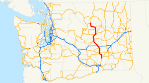

State Route 17 is a highway in the state of Washington, U.S.A. It extends about 137 miles from U.S. Route 395 in the tiny town of Mesa, in the south central part of the state, to U.S. Route 97 at the confluence of the Okanogan and Columbia Rivers near Brewster.

Route description

State Route 17 begins at an interchange with U.S. Route 395 just southeast of Mesa. It then heads in a northwesterly direction, intersecting State Route 26 as it passes by Othello, and has an interchange with Interstate 90 near the city of Moses Lake.

North of Interstate 90, SR 17 travels through the Grand Coulee for about 20 miles, along the shores of Soap Lake, Lenore Lake, Blue Lake, and Park Lake, all remnants of a major river that flowed through this part of the state about 2 million years ago. SR 17 meets U.S. Route 2 at the southern shore of Banks Lake, then leaves the coulee and extends due north through farmland for about 20 more miles before turning left and following a dry river bed into Bridgeport, where it crosses the Columbia just west of Chief Joseph Dam. The highway follows the east bank of the Columbia for a few more miles inside the Colville Indian Reservation before terminating at US 97 east of Brewster.

Mileposts on SR 17 begin with milepost 8, posted about half a mile north of the highway's origin at US 395. Prior to 1979, SR 17 began at Eltopia, about 7½ miles south of Mesa. That year, US 395 was rerouted from what is now Blanton Road in Franklin County to its current routing, which eliminated the portion of SR 17 that formerly ran between Eltopia and Mesa. SR 17 now originates in Mesa, but new mileposts have not been posted on the route reflecting the highway's new starting point.

Major intersections

References

External links

* [http://www.angelfire.com/wa2/hwysofwastate/sr017.html Highways of Washington State]


Wikimedia Foundation. 2010.

Игры ⚽ Нужно сделать НИР?

Look at other dictionaries:

  • Washington State Route 20 — State Route 20 Whidbey Scenic Isle Way North Cascades Highway …   Wikipedia

  • Washington State Route 31 — State Route 31 Nearby state routes with SR 31 highlighted in red. Route inform …   Wikipedia

  • Washington State Route 20 — (SR 20) Autres noms North Cross Highway Longueur 701,87 …   Wikipédia en Français

  • Washington State Route 14 — La State Route 14, également appelée Lewis and Clark Highway, est une route d État dans l État de Washington, aux États Unis. Elle s étend sur environ 290 kilomètres à partir de sa jonction avec l autoroute Interstate 5 à Vancouver dans l… …   Wikipédia en Français

  • Washington State Route 27 — infobox WA State Route type=State route=27 sec=115 length mi=90.00 length ref= length round=2 formed=1964 dir1=South dir2=North from= junction= to= in Spokane Valley previous type=State previous route=26 next type=State next route=28State Route… …   Wikipedia

  • Washington State Route 16 — Karte …   Deutsch Wikipedia

  • Washington State Route 12 — Several highways in the U.S. state of Washington have been numbered 12: *U.S. Route 12 in Washington *Washington State Route 12 (1964 1967), now SR 14 *Primary State Highway 12 (Washington) (1937 1970) and State Road 12 (Washington 1923 1937),… …   Wikipedia

  • Washington State Route 525 — State Route 525 Whidbey Scenic Isle Way …   Wikipedia

  • Washington State Route 524 Spur — State Route 524 Spur may refer to:*State Route 524 Spur (Edmonds, Washington), Third Avenue and Pine Street in Edmonds, Washington *State Route 524 Spur (Lynnwood, Washington), 44th Avenue W in Lynnwood, Washingtonee also*Washington State Route… …   Wikipedia

  • Washington State Route 504 — La State Route 504, également appelée Spirit Lake Memorial Highway, est une route d État dans les comtés de Cowlitz et de Skamania, dans l État de Washington, aux États Unis. Elle s étend sur environ 83,3 kilomètres et effectue une jonction… …   Wikipédia en Français

  • Washington State Route 14 — State Route 14 Route information D …   Wikipedia

Share the article and excerpts

Direct link
Do a right-click on the link above
and select “Copy Link”