- Washington State Route 202
Infobox WA State Route
type=SR
route=202
sec=385
formed=1964
length_mi=30.55
length_ref=cite web|author=Washington State Department of Transportation |url=http://www.wsdot.wa.gov/mapsdata/tdo/PDF_and_ZIP_Files/HwyLog2005B.pdf|title=State Highway Log, 2005 B|accessdate=2007-04-21]
length_round=2
dir1=West|dir2=East
from=
junction=
to=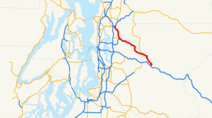
previous_type=US
previous_route=197
next_type=WA
next_route=203
spur_type=US
spur_of=2State Route 202, also known as SR 202, is a
highway in thestate ofWashington ,U.S.A. It runs southeast for 30 miles, from State Route 522 in Woodinville to Interstate 90 in North Bend. SR 202 is entirely within King County.Route description
The northwestern end of SR 202 is an interchange with SR 522 at the Bothell-Woodinville border. At that point, SR 202 is 131st Avenue Northeast. At the intersection of 131st Avenue Northeast and Woodinville-Duvall Road, SR 202 follows Woodinville-Duvall Road to the west over the
Sammamish River . Across the river, SR 202 turns again, this time southeast, and becomes Woodinville-Redmond Road Northeast. It continues southeast until it intersects Northeast 145th Street, which SR 202 follows toward the east. After crossing the Sammamish River again, SR 202 breaks its concurrency with Northeast 145th Street to become Woodinville-Redmond Road again.SR 202 continues to the south-southeast as Woodinville-Redmond Road until it reaches downtown Redmond. There it is abutted by State Route 908, which goes west to Kirkland. At the intersection with SR 908, SR 202 turns to the east-southeast and becomes a two-lane, one-way street through downtown Redmond. After a few blocks, SR 202 intersects Cleveland Street and Avondale Way and returns to a two-way road, now called Redmond-Fall City Road. SR 202 then passes under State Route 520.
Near the edge of Redmond, East Lake Sammamish Parkway NE (part of former State Route 901) branches off SR 202. SR 202 then emerges into unincorporated King County. SR 202 continues southeast to Fall City where it joins with Preston-Fall City Road and crosses the
Snoqualmie River . Across the river, State Route 203 starts and heads north to Carnation, while SR 202 (now SE Fall City-Snoqualmie Road) turns east into the foothills of the Cascades. In the foothills, SR 202 passesSnoqualmie Falls , crosses the Snoqualmie River again, and passes through the town of Snoqualmie. After Snoqualmie, SR 202 (now SE Snoqualmie-North Bend Road) reaches the town of North Bend, where it takes a 90-degree turn to the southwest and (as North Bend Boulevard) intersects I-90 at Exit 31.SR 202 Corridor Plan
WSDOT is working with representatives from local agencies and communities to identify transportation-related problems and potential improvement projects for State Route 202 in east King County. The result of this effort will be the [http://www.wsdot.wa.gov/planning/RDP/SR202/SahaleeWayToDuthieHill/Default.htm SR 202 corridor study] a plan that will include a list of short- and long-term highway projects to address safety and mobility issues on SR 202 from Sahalee Way N.E. to Duthie Hill Road (292nd Avenue S.E.) near the City of Sammamish.Local representatives and agencies can use the proposed improvement projects list to solicit funding and make decisions about how to invest resources over the next20 years to address safety and mobility issues.History
SR 202 was formed in
1964 from the Bothell-Monroe branch of Primary State Highway 15 [ [http://www.angelfire.com/wa2/hwysofwastate/psh015.html Highways of Washington State: Primary State Highway 15] ] . At this time, almost all of present-day SR 202 was part of SR 522, and present-day SR 522 from Woodinville to Monroe was part of SR 202. In1970 , SR 522 and SR 202 were switched, yielding their present configuration [ [http://www.angelfire.com/wa2/hwysofwastate/sr202.html Highways of Washington State: SR 202] ] . As a result of this change, SR 202, although a child route of U.S. Route 2, does not currently connect to US 2. Originally it did at the current junction of US 2 and SR 522 in Monroe.References
External links
* [http://www.wsdot.wa.gov/ Washington State Department of Transportation]
* [http://www.wsdot.wa.gov/planning/RDP/SR202/SahaleeWayToDuthieHill/Default.htm State Route 202 Sahalee Way to Duthie Hill Road Corridor Study]

Wikimedia Foundation. 2010.