- Monroe, Washington
-
Monroe, Washington — City — Location of Monroe, Washington
Coordinates: 47°51′28″N 121°59′18″W / 47.85778°N 121.98833°WCoordinates: 47°51′28″N 121°59′18″W / 47.85778°N 121.98833°W Country United States State Washington County Snohomish Area - Total 5.8 sq mi (15.0 km2) - Land 5.8 sq mi (15.0 km2) - Water 0.0 sq mi (0.1 km2) Elevation 72 ft (22 m) Population (2010) - Total 17,304 - Density 2,388.4/sq mi (921.5/km2) Time zone Pacific (PST) (UTC-8) - Summer (DST) PDT (UTC-7) ZIP code 98272 Area code 360 FIPS code 53-46685[1] GNIS feature ID 1523319[2] Website http://www.ci.monroe.wa.us/ Monroe is a city in Snohomish County, Washington, United States. The population as of 17,304 at the 2010 census.
Contents
History
The history of Monroe is intertwined with that of the Great Northern Railway which pushed over the Cascade Range at Stevens Pass and worked its way down the Skykomish River Valley.[3]
Prior to that time the main settlement in the area had been located about one mile west of where the downtown eventually grew up and was known as Park Place. However, the city's merchants relocated when the railroad survey was completed to have better access to the new transportation corridor. The new development was originally known as Tye City, but became Monroe when Park Place's main store, the one containing the U.S. Post Office, relocated and took up the name "Monroe at Park Place" in honor of James Monroe, the nation's fifth president. Because the U.S. Postal Department would not allow any new post offices to use double names, the post office, and eventually the town, became known simply as "Monroe."[4]
By 1893 the city had become an important stop on the rail line and was best known for the GN Greenhouses, which grew flowers for the passengers to purchase. That same year, Snohomish County built the County Poor Farm where today's Evergreen State Fairgrounds are located; the city's first hospital was built where Valley General Hospital stands today. 1894 saw the construction of the first high bridge over the Skykomish River and 1896 the construction of the first church. In 1899 the grammar school was relocated from its old site in Park Place to a new site in Monroe and the town's newspaper, The Monroe Monitor, began publication on January 14 of the same year. On September 16, 1901 a fire destroyed the only complete block of business in the city.
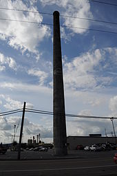 Carnation Condensery Stack (photographed 2009).
The economic area of the city saw a series of development as well. While the city was still in its infancy, many sawmills were constructed to take advantage of the area's old growth cedar and cedar shakes became the main product. However, as the timber played out and the logging industry slowly moved away, agriculture became the area's new industry and berry farms began to flourish. Because of the lush valley grasses, dairy farms too moved into the area and soon several creameries began production. Evidence of this industry can still be seen today as the giant smokestack of the Carnation Condensery, a factory which was destroyed by fire in the 1940s, still stands in the middle of what is today a grocery store parking lot at the intersection of Main Street and US Route 2. It is a lone reminder of this forgotten industrial era and, despite its age, it remains much taller than any other structure in the city.
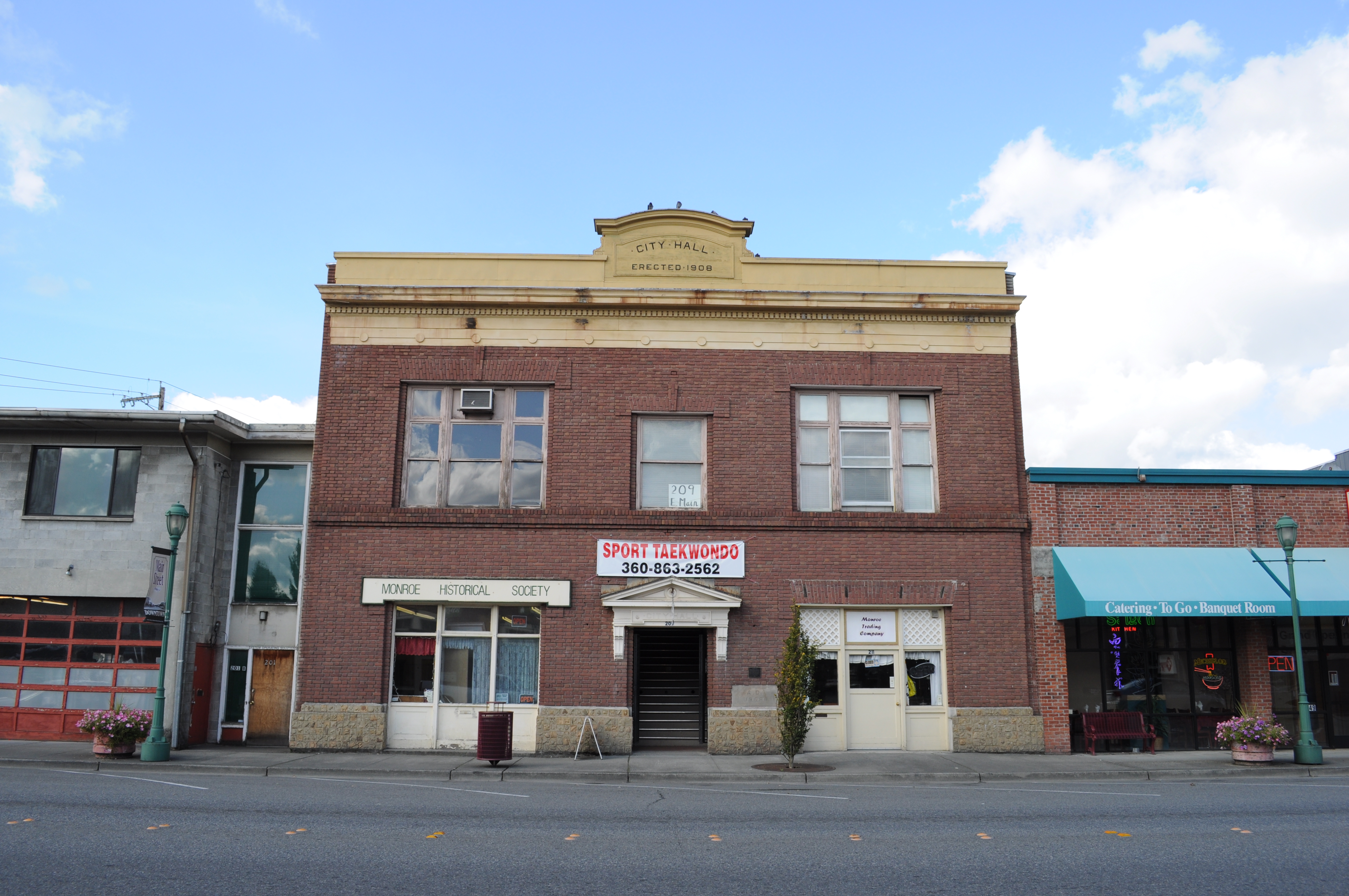
 Old City Hall, built 1908, now (2009) home to the Monroe Historical Society and Monroe Historical Museum.
The City of Monroe officially voted to incorporate on December 20, 1902 and the new city counted 325 people in its population. In 1910, around the same time as the construction of the Carnation Condensery, Washington State chose Monroe as the site of the Washington State Reformatory.
The Great Depression struck Monroe as it did elsewhere in the nation and much of the town's industry closed down. As a result, the city fathers applied for national funds and established programs to help the town. The funds built a school, which can still be seen on Main Street, as well as road improvements. In 1941, the first fair was held in Monroe, known as the Cavalcade of the Valleys, at the County Poor Farm. Although interrupted by World War II, the fair resumed in 1946 with the help of many local residents such as Mr. and Mrs. Shine Peters, then owners of Monroe Floral, who helped plant all the flowers shrubs and trees that decorated the grounds from their nursery. Local farmers and Grange members' contributions helped establish many traditions the Evergreen State Fair continues to take pride in. The annual fair remains an important part of the city's culture today.
 This old house near the center of Monroe has been more recently used as a shop.
After the depression and war, industry did not return to the city and the town became ever more oriented towards agriculture. It continued to grow, albeit slowly, throughout much of the 1950s and '60s. In April 1965 a major earthquake struck Western Washington and the original Monroe High School and its annex were so severely damaged that they later had to be demolished. The new high school opened in 1968 and served the city until a new larger High School had to be built in 1999.[5]
In the early 1970s Monroe became the terminus for State Route 522 (Originally SR202, before being realigned into SR522), which offers a more direct connection to Interstate 405 and larger cities to the south. This has opened the city up and helped to establish it as a true bedroom community. The highway meets up with U.S. Route 2 in the town and the intersection is often filled with intrastate traffic.
 The Doloff-Key building at the very center of old Monroe, the corner of Main and Lewis Streets, dates back to 1901. Pictured here in 2009.
During the first decade of the 21st century, Monroe saw growth in unexpected new proportions as many large strip malls and major retailers have built new complexes along Highway 2. The city's residential areas have greatly expanded as well and the highway has become the scene of major gridlock, especially during summer months and major holidays. At the time of this writing, a bypass is being considered but no firm plans have been agreed upon.
The new developments have added to the city and the influx of people into the surrounding area has changed, but not erased much of the city's charm. The old part of town stands much as it always has, on Main Street away from the busy highway, and has managed to preserve much of its small town character. Trains still regularly pass through the town on their way across Stevens Pass and the sound of their horns is a common feature of life in the city.
Since 2007, Monroe's Old Town district has begun a revitalization program.[6][7]
Monroe has also been host to a few Hollywood films, such as The Ring (2002), The Ring Two (2005), and The Butterfly Effect (2004).
Once per year from 1995 until 2000, the NASCAR Craftsman Truck Series held a race at the Evergreen Speedway located at the Evergreen State Fairgrounds.
Geography
Monroe is located at 47°51′28″N 121°59′18″W / 47.857722°N 121.988364°W (47.857722, -121.988364).[8]
According to the United States Census Bureau, the city has a total area of 5.8 square miles (15.0 km2), of which, 5.8 square miles (15.0 km2) of it is land and 0.04 square miles (0.1 km2) of it (0.52%) is water.
Demographics
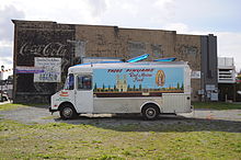 A taco truck on E. Main Street, 2009, reflects the increasing Mexican presence in Monroe.
Historical populations Census Pop. %± 1910 1,552 — 1920 1,675 7.9% 1930 1,570 −6.3% 1940 1,590 1.3% 1950 1,556 −2.1% 1960 1,901 22.2% 1970 2,687 41.3% 1980 2,869 6.8% 1990 4,275 49.0% 2000 13,795 222.7% 2010 17,304 25.4% As of the census[1] of 2000, there were 13,795 people, 4,173 households, and 3,058 families residing in the city. The population density was 2,388.4 people per square mile (921.5/km2). There were 4,427 housing units at an average density of 766.5 per square mile (295.7/km2). The racial makeup of the city was 86.13% White, 3.15% African American, 1.32% Native American, 2.38% Asian, 0.31% Pacific Islander, 4.01% from other races, and 2.70% from two or more races. Hispanic or Latino of any race were 9.66% of the population. 21.0% were of German, 10.1% English and 9.3% Irish ancestry according to Census 2000.
There were 4,173 households out of which 45.7% had children under the age of 18 living with them, 57.8% were married couples living together, 10.5% had a female householder with no husband present, and 26.7% were non-families. 20.6% of all households were made up of individuals and 8.6% had someone living alone who was 65 years of age or older. The average household size was 2.83 and the average family size was 3.26.
In the city the age distribution of the population shows 27.4% under the age of 18, 8.9% from 18 to 24, 41.4% from 25 to 44, 14.2% from 45 to 64, and 8.0% who were 65 years of age or older. The median age was 31 years. For every 100 females there were 126.7 males. For every 100 females age 18 and over, there were 137.3 males.
The median income for a household in the city was $50,390, and the median income for a family was $55,793. Males had a median income of $39,847 versus $31,633 for females. The per capita income for the city was $18,912. About 5.6% of families and 8.9% of the population were below the poverty line, including 9.2% of those under age 18 and 14.7% of those age 65 or over.
Education
 The former Monroe Elementary School on S. Ferry St. (built 1916), now (in 2009) the Monroe School District Administration Building.
High school
Middle schools
- Monroe Middle School
- Park Place Middle School
- Hidden River Middle School
Elementary schools
- Salem Woods Elementary
- Chain Lake Elementary
- Fryelands Elementary
- Frank Wagner Elementary
Correctional centers
As stated above, The Washington State Reformatory was originally built in 1910. It was originally intended to house young offenders, keeping them separate from the hardcore older offenders. In 1981, the Special Offender Center was opened to treat offenders with mental health issues. Twin Rivers Correctional Center opened in 1994 as a 500-bed medium-custody facility. The Minimum-Security Unit opened in 1997 to house minimum-custody offenders. In 1998, the four facilities merged into the Monroe Correctional Complex under one Superintendent. The facilities were re-named the Washington State Reformatory Unit (WSRU), Twin Rivers Unit (providing the state's only male sex-offender treatment program in the prison system), Special Offender Unit (for mental health treatment) and the Minimum-Security Unit retained its name. The Intensive Management Unit (IMU) opened in 2007 as the newest addition to the Monroe Correctional Complex. The 100-bed Intensive Management Unit will house behaviorally difficult-to-manage offenders in a highly-controlled environment. Since the reformatory first opened, the prison has employed a large number of locals.[9]
References
- ^ a b "American FactFinder". United States Census Bureau. http://factfinder.census.gov. Retrieved 2008-01-31.
- ^ "US Board on Geographic Names". United States Geological Survey. 2007-10-25. http://geonames.usgs.gov. Retrieved 2008-01-31.
- ^ "Monroe Historical Society". Monroe Historical Society. http://www.monroehistoricalsociety.org/index.html. Retrieved 2007-08-27.
- ^ "The Memories of Hiram Ellsworth Pearsall". Monroe Historical Society. http://www.monroehistoricalsociety.org/pearsall.html. Retrieved 2007-08-27.
- ^ "Monroe Historical Time Line". Monroe Historical Society. http://www.monroehistoricalsociety.org/timeline.html. Retrieved 2007-08-27.
- ^ Monroe Dream
- ^ Monroe Dream video
- ^ "US Gazetteer files: 2010, 2000, and 1990". United States Census Bureau. 2011-02-12. http://www.census.gov/geo/www/gazetteer/gazette.html. Retrieved 2011-04-23.
- ^ "Monroe Correctional Complex". Washington State Department of Corrections. 2007. http://www.doc.wa.gov/facilities/monroe.asp. Retrieved 2008-11-07.[dead link]
External links
 State of Washington
Olympia (capital) Topics State government | Cities | Towns | Congressional delegation | City governments | Governors | History | Geography | People | Legislative initiatives | Popular initiatives | Legislature | Music | Parks | Highways | Symbols | Visitor attractions
Society Demographics · Economy · Education · Politics
Regions Larger cities and
metropolitan areasSeattle | Seattle metropolitan area | Spokane | Tacoma | Tri-Cities | Vancouver | Bellevue | Everett | Yakima
Smaller cities Aberdeen | Anacortes | Arlington | Auburn | Bainbridge Island | Battle Ground | Bellingham | Bonney Lake | Bothell | Bremerton | Burien | Camas | Centralia | Cheney | Cle Elum | Coupeville | Covington | Des Moines | East Wenatchee | Edmonds | Ellensburg | Enumclaw | Federal Way | Fort Lewis | Grandview | Hoquiam | Issaquah | Kelso | Kenmore | Kennewick | Kent | Kirkland | Lacey | Lake Forest Park | Lake Stevens | Lakewood | Langley | Longview | Lynden | Lynnwood | Mabton | Maple Valley | Marysville | Mercer Island | Mill Creek | Monroe | Moses Lake | Mountlake Terrace | Mount Vernon | Mukilteo | Naches | Oak Harbor | Olympia | Pasco | Port Angeles | Port Orchard | Port Townsend | Prosser | Pullman | Puyallup | Redmond | Renton | Richland | Sammamish | SeaTac | Sedro-Woolley | Selah | Shelton | Shoreline | Silverdale | Spokane Valley | Sunnyside | Toppenish | Tukwila | Tumwater | University Place | Walla Walla | Wapato | Washougal | Wenatchee | West Richland | Woodinville | Zillah
Counties Adams | Asotin | Benton | Chelan | Clallam | Clark | Columbia | Cowlitz | Douglas | Ferry | Franklin | Garfield | Grant | Grays Harbor | Island | Jefferson | King | Kitsap | Kittitas | Klickitat | Lewis | Lincoln | Mason | Okanogan | Pacific | Pend Oreille | Pierce | San Juan | Skagit | Skamania | Snohomish | Spokane | Stevens | Thurston | Wahkiakum | Walla Walla | Whatcom | Whitman | Yakima
Categories:- Cities in Washington (state)
- Populated places in Snohomish County, Washington
- Cities in the Seattle metropolitan area
- Populated places established in 1903


Wikimedia Foundation. 2010.