- Woodway, Washington
Infobox Settlement
official_name = Woodway, Washington
settlement_type =City
nickname =
motto =
imagesize =
image_caption =
image_
imagesize =
image_caption =
image_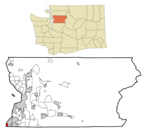
mapsize = 250px
map_caption = Location of Woodway, Washington
mapsize1 =
map_caption1 =subdivision_type = Country
subdivision_name =United States
subdivision_type1 = State
subdivision_name1 =Washington
subdivision_type2 = County
subdivision_name2 = Snohomishgovernment_footnotes =
government_type =
leader_title =
leader_name =
leader_title1 =
leader_name1 =
established_title =
established_date =unit_pref = Imperial
area_footnotes =area_magnitude =
area_total_km2 = 10.1
area_land_km2 = 2.9
area_water_km2 = 7.2
area_total_sq_mi = 3.9
area_land_sq_mi = 1.1
area_water_sq_mi = 2.8population_as_of = 2000
population_footnotes =
population_total = 936
population_density_km2 = 324.4
population_density_sq_mi = 840.1timezone = Pacific (PST)
utc_offset = -8
timezone_DST = PDT
utc_offset_DST = -7
elevation_footnotes =
elevation_m = 62
elevation_ft = 203
latd = 47 |latm = 47 |lats = 24 |latNS = N
longd = 122 |longm = 22 |longs = 56 |longEW = Wpostal_code_type =
ZIP code
postal_code = 98020
area_code = 425
blank_name = FIPS code
blank_info = 53-79835GR|2
blank1_name = GNIS feature ID
blank1_info = 1512815GR|3
website =
footnotes =Woodway or the Town of Woodway is a city in Snohomish County,
Washington ,United States . The population was 936 at the 2000 census.Based on per capita income, one of the more reliable measures of affluence, Woodway ranks 8th of 522 areas in the state of Washington to be ranked. It is also the highest rank achieved in Snohomish County.
History
Woodway was officially incorporated on
February 26 ,1958 . At that time, Woodway had its own high school, called Woodway High School. In 1990, this school merged with Edmonds High School to createEdmonds Woodway High School .Woodway has no street lights, to prevent light pollution.
Geography
Woodway is located at coor dms|47|47|24|N|122|22|56|W|city (47.790038, -122.382360)GR|1.
According to the
United States Census Bureau , the city has a total area of 3.9square mile s (10.1km² ), of which, 1.1 square miles (2.9 km²) of it is land and 2.8 square miles (7.2 km²) of it (71.54%) is water.Demographics
As of the
census GR|2 of 2000, there were 936 people, 336 households, and 280 families residing in the city. Thepopulation density was 840.1 people per square mile (325.6/km²). There were 343 housing units at an average density of 307.9/sq mi (119.3/km²). The racial makeup of the city was 94.12% White, 0.32% Native American, 3.85% Asian, 0.43% from other races, and 1.28% from two or more races. Hispanic or Latino of any race were 0.85% of the population.There were 336 households out of which 34.8% had children under the age of 18 living with them, 77.7% were married couples living together, 5.4% had a female householder with no husband present, and 16.4% were non-families. 14.0% of all households were made up of individuals and 7.7% had someone living alone who was 65 years of age or older. The average household size was 2.76 and the average family size was 3.02.
In the city the population was spread out with 24.4% under the age of 18, 4.0% from 18 to 24, 17.8% from 25 to 44, 34.1% from 45 to 64, and 19.8% who were 65 years of age or older. The median age was 47 years. For every 100 females there were 91.8 males. For every 100 females age 18 and over, there were 86.3 males.
The median income for a household in the city was $101,633, and the median income for a family was $109,428. Males had a median income of $86,928 versus $33,333 for females. The
per capita income for the city was $51,613. About 0.7% of families and 2.4% of the population were below thepoverty line , including 0.9% of those under age 18 and 3.3% of those age 65 or over.References
External links
* [http://www.townofwoodway.com/default.htm Official Site]
Wikimedia Foundation. 2010.