- Yakima River
Geobox River
name = Yakima River
native_name =
other_name =
other_name1 =
image_size = 300
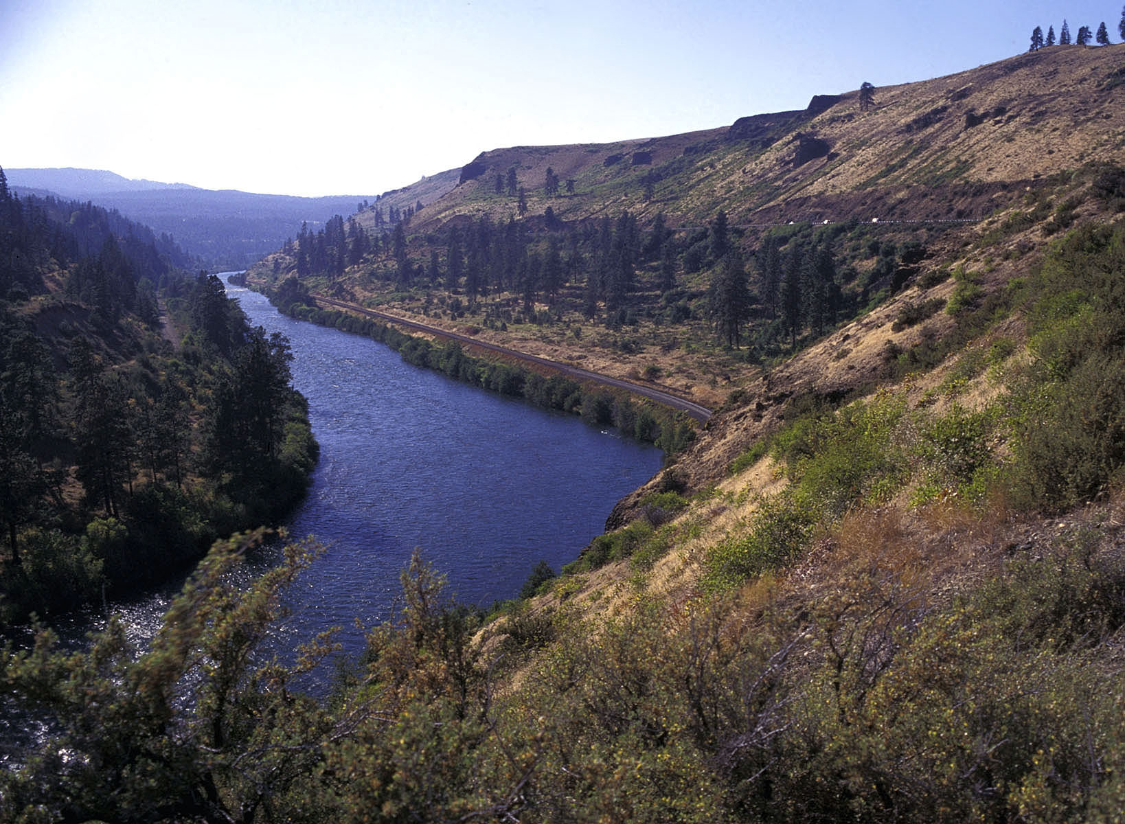
image_caption = State Route 10 winds past the Yakima River (©2004 Mountains to Sound Greenway Trust)
country = United States
country1 =
state = Washington
state1 =
region =
region1 =
district =
district1 =
city = Cle Elum
city1 = Ellensburg
city2 = Yakima
city3 = Sunnyside
city4 = Richland
length_imperial = 214
length_note = [http://www.nwcouncil.org/fw/subbasinplanning/yakima/plan/1_Overview.pdf Yakima Subbasin Plan Overview] , Northwest Power and Conservation Council]
watershed_imperial = 6150
watershed_note =
discharge_location = Kiona, RM 30
discharge_imperial = 3493
discharge_max_imperial = 59400
discharge_min_imperial = 225
discharge_note = [http://pubs.usgs.gov/wdr/2005/wdr-wa-05-1/pdf/wa00103ADR2005_Figure60.pdf Yakima River and Esquatzel Coulee Basins and the Columbia River from Richland to Kennewick] , Water Resources Data-Washington Water Year 2005]
discharge1_location = Mabton, RM 60
discharge1_imperial = 3311
discharge2_location = Union Gap, RM 107
discharge2_imperial = 3542
discharge3_location = Umtanum, RM 140
discharge3_imperial = 2430
source_name = Keechelus Lake
source_location = Kittitas County
source_district =
source_region =
source_state = Washington
source_country =
source_lat_d = 47
source_lat_m = 19
source_lat_s = 20
source_lat_NS = N
source_long_d = 121
source_long_m = 20
source_long_s = 21
source_long_EW = W
source_coordinates_note = Gnis|1528343|Yakima River,USGS GNIS.]
source_elevation_imperial = 2520
source_elevation_note = [Google Earth elevation for GNIS source coordinates.]
source_length_imperial =
mouth_name = Columbia River
mouth_location = Richland
mouth_district =
mouth_region = Benton County
mouth_state = Washington
mouth_country =
mouth_lat_d = 46
mouth_lat_m = 15
mouth_lat_s = 10
mouth_lat_NS = N
mouth_long_d = 119
mouth_long_m = 13
mouth_long_s = 51
mouth_long_EW = W
mouth_coordinates_note =
mouth_elevation_imperial = 344
mouth_elevation_note = [Google Earth elevation for GNIS mouth coordinates.]
tributary_left = Cle Elum River
tributary_left1 = Teanaway River
tributary_right = Naches River
tributary_right1 =
free_name =
free_value =
map_size = 300
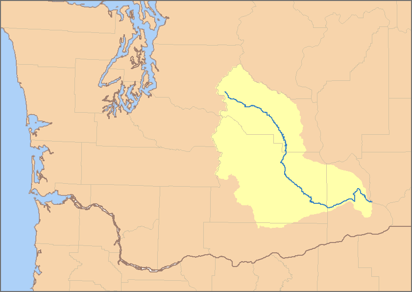
map_caption = Map of the Yakima River watershed The Yakima River is a tributary of theColumbia River in south central and easternWashington State, named for the indigenousYakama people. The length of the river from headwaters to mouth is convert|214|mi|km|0, with an average drop of river drop|9.85.Course
The river rises in the
Cascade Range at an elevation of convert|2449|ft|m|0 at Keechelus Dam onKeechelus Lake nearSnoqualmie Pass , northwest of Cle Elum. The river flows through that town, skirts Ellensburg, passes the city of Yakima, and continues southeast to Richland, where it flows into theColumbia River at an elevation of convert|340|ft|m|0.History
The first western explorers to visit the river were Lewis and Clark on or about Oct 17, 1805. They stopped briefly at the confluence of the Yakima and the Columbia, although they did not proceed upriver. The river was then known to local Native Americans as 'Tap Teel', although the area has been inhabited since prehistory.
Yakima Valley
The Yakima River Basin consists of approximately sq mi to km2|6150|precision=-1 located in south central Washington State. It is bounded by the Cascade Mountains on the west, the
Wenatchee Mountains on the north, Rattlesnake Mountain and theRattlesnake Hills on the east, and theHorse Heaven Hills to the south. The basin encompasses areas designated by theWashington Department of Ecology as the Upper Yakima Water Resource Inventory Areas (WRIAs) 38 and 39 and the Lower Yakima WRIA 37. The dividing line between these northern and southern sections is the confluence of the Naches and Yakima Rivers.The Yakima River provides
irrigation for the dry but fertile land in the valley, and irrigated agriculture is the economic base. Agricultural land totals sq mi to km2|1000|precision=-2, including irrigated pastures, orchards, grapes, hops, and field crops. A significant portion of Washington apples andcherries are grown in the valley, as well as most of the United States's hops. Since the late 20th century, thewine industry has grown rapidly in the area. It is the location of theYakima Valley AVA , a designatedAmerican Viticultural Area .Major landowners in the valley include federal and state agencies and the Yakama Indian Nation. Private ownership accounts for convert|1246818|acre|km2|2. The
United States Forest Service manages convert|892509|acre|km2|2, and the Yakama Nation owns convert|889786|acre|km2|2 within the basin. Forested areas in the northern and western portions of the basin occupy approximately sq mi to km2|2200|precision=-2 and are used for recreation, wildlife habitat, timber harvest, grazing, and tribal cultural activities. Range lands comprise about sq mi to km2|2900|precision=-2 and are used for military training, grazing, wildlife habitat, and tribal cultural activities.Major population centers include the cities of Yakima and Richland. Population growth for the 1990s was projected at 7.9% in Kittitas County, 19.7% in Yakima County, and 22.7% in Benton County. While much of the growth in Benton and Yakima counties has been in and around the incorporated areas, most of the growth in Kittitas County has been in unincorporated areas.
In addition to irrigated agriculture, the major economic driving forces include timber harvest and processing, cattle, and outdoor recreation. With the significant reduction in timber harvesting on federal lands and the implementation of the
Northwest Forest Plan to protect the endangeredNorthern Spotted Owl , the timber economy has been greatly eroded in recent years. The proximity to high population areas of thePuget Sound has caused a rapid increase in the demand for outdoor recreational experiences in the basin. [http://web.archive.org/web/20030404030211/http://yosemite.epa.gov/R10%5cecocomm.nsf/ecoweb/Yakima+River+Basin+Fiscal+Year+1997+Performance+Plan United States EPA Performance Plan] ]River modifications
The Yakima River and its tributaries have been heavily altered for the purpose of irrigated agriculture. There are numerous dams and irrigation canals. Irrigation runoff is in places returned to the river through canal drains. The irrigation system in the Yakima's watershed causes periods of both severe river dewatering and elevated flows, relative to the historic streamflow regime. As a result, discharge statistics for the Yakima River are heavily effected by the irrigation system. The
USGS operates four streamflow gages on the Yakima River. The highest average discharge recorded, convert|3542|cuft/s|m3/s more than halfway up the river at Union Gap. The two downriver gages show average flows of a reduced amount.ee also
*
Tributaries of the Columbia River
*Yakima Valley AVA References
Wikimedia Foundation. 2010.