- Columbia County, Washington
-
Columbia County, Washington 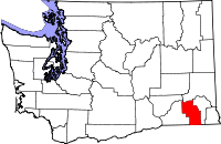
Location in the state of Washington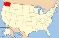
Washington's location in the U.S.Founded November 11, 1875 Seat Dayton Area
- Total
- Land
- Water
874 sq mi (2,264 km²)
869 sq mi (2,251 km²)
5 sq mi (13 km²), 0.54%Population
- (2010)
- Density
4,078
5/sq mi (2/km²)Website www.columbiaco.com Columbia County is a county located in the U.S. state of Washington. As of 2010, the population was 4,078. The county seat is at Dayton, which is also the county's largest city. It is named after the Columbia River.
Columbia County was created out of Walla Walla County on November 11, 1875.[1]
Contents
Geography
According to the U.S. Census Bureau, the county has a total area of 874 square miles (2,263.6 km2), of which 869 square miles (2,250.7 km2) is land and 5 square miles (12.9 km2) (0.54%) is water. It is part of the Palouse, a wide and rolling prairie-like region of the middle Columbia basin.
Geographic features
Major highways
 U.S. Route 12
Adjacent counties
- Whitman County, Washington - north
- Garfield County, Washington - east
- Wallowa County, Oregon - southeast
- Umatilla County, Oregon - southwest
- Walla Walla County, Washington - west
- Franklin County, Washington - northwest
National protected area
- Umatilla National Forest (part)
Demographics
Historical populations Census Pop. %± 1880 7,103 — 1890 6,709 −5.5% 1900 7,128 6.2% 1910 7,042 −1.2% 1920 6,093 −13.5% 1930 5,325 −12.6% 1940 5,549 4.2% 1950 4,860 −12.4% 1960 4,569 −6.0% 1970 4,439 −2.8% 1980 4,057 −8.6% 1990 4,027 −0.7% 2000 4,064 0.9% 2010 4,078 0.3% As of the census[2] of 2000, there were 4,064 people, 1,687 households, and 1,138 families residing in the county. The population density was 5 people per square mile (2/km²). There were 2,018 housing units at an average density of 2 per square mile (1/km²). The racial makeup of the county was 93.73% White, 0.22% Black or African American, 0.96% Native American, 0.42% Asian, 0.05% Pacific Islander, 2.73% from other races, and 1.89% from two or more races. 6.35% of the population were Hispanic or Latino of any race. 19.6% were of German, 18.2% United States or American, 14.3% English and 8.3% Irish ancestry according to Census 2000. 94.3% spoke English and 5.7% Spanish as their first language.
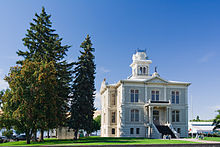 Columbia County courthouse
There were 1,687 households out of which 27.70% had children under the age of 18 living with them, 56.00% were married couples living together, 8.50% had a female householder with no husband present, and 32.50% were non-families. 29.00% of all households were made up of individuals and 13.00% had someone living alone who was 65 years of age or older. The average household size was 2.36 and the average family size was 2.89.
In the county, the population was spread out with 23.90% under the age of 18, 7.00% from 18 to 24, 22.80% from 25 to 44, 27.70% from 45 to 64, and 18.50% who were 65 years of age or older. The median age was 42 years. For every 100 females there were 95.20 males. For every 100 females age 18 and over, there were 94.80 males.
The median income for a household in the county was $33,500, and the median income for a family was $44,038. Males had a median income of $33,690 versus $21,367 for females. The per capita income for the county was $17,374. About 8.60% of families and 12.60% of the population were below the poverty line, including 15.90% of those under age 18 and 11.10% of those age 65 or over.
Census-recognized communities
Other communities
- Alto
- Turner
- Huntsville
- Marengo
See also
References
- ^ "Milestones for Washington State History — Part 2: 1851 to 1900". HistoryLink.org. 2003-03-06. http://www.historylink.org/essays/output.cfm?file_id=5380.
- ^ "American FactFinder". United States Census Bureau. http://factfinder.census.gov. Retrieved 2008-01-31.
External links

Franklin County Whitman County Walla Walla County 
Garfield County  Columbia County, Washington

Umatilla County, Oregon Wallowa County, Oregon Municipalities and communities of Columbia County, Washington City 
Town Categories:- Washington (state) counties
- Columbia County, Washington
- 1875 establishments


Wikimedia Foundation. 2010.