- Umatilla National Forest
Infobox_protected_area | name = Umatilla National Forest
iucn_category = VI

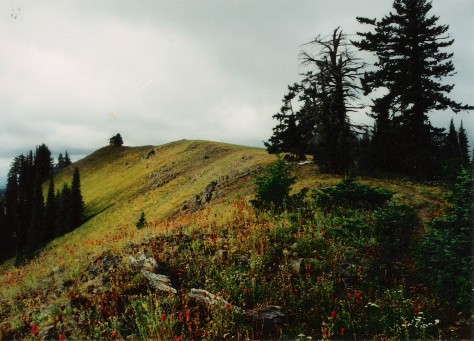
caption = Oregon Butte in the Wenaha-Tucannon Wilderness, Umatilla NF
locator_x =
locator_y =
location =Oregon , USA
nearest_city =Elgin, Oregon
lat_degrees = 45
lat_minutes = 38
lat_seconds = 00
lat_direction = N
long_degrees = 118
long_minutes = 11
long_seconds = 00
long_direction = W
area = Convert|1800000|acre|km2|0
established =
visitation_num = 703,000 [http://www.fs.fed.us/recreation/programs/nvum/revised_vis_est.pdf Revised Visitation Estimates] - National Forest Service]
visitation_year = 2006
governing_body = U.S. Forest ServiceThe Umatilla National Forest, in the Blue Mountains of northeast
Oregon and southeastWashington , covers an area of 1.4 million acres (5,700 km²). In descending order of land area the forest is located in parts of Umatilla, Grant, Columbia, Morrow, Wallowa, Union, Garfield, Asotin, Wheeler, and Walla Walla counties. (Columbia, Garfield, Asotin, and Walla Walla counties are in Washington, while the rest are in Oregon.) More than three-quarters of the forest lies in the state of Oregon. [ [http://www.fs.fed.us/land/staff/lar/2007/TABLE_6.htm Table 6 - NFS Acreage by State, Congressional District and County] -United States Forest Service - September 30, 2007] Forest headquarters are located inPendleton, Oregon .Human history
The Umatilla National Forest takes its name from the Umatilla Indian word meaning "water rippling over sand." Explorers
Lewis and Clark passed through the area in 1805 on theColumbia River , and Marcus and Narcissa Whitman passed through in 1836 to establish a mission at Wailatpu nearWalla Walla, Washington . Thousands of emigrants later followed theOregon Trail west, and many remained in the Blue Mountain region. Discovery of gold in Oregon in 1851 led to the settlement of the North Fork John Day River area. Over $10 million in gold and silver were mined, and remnants of the era are still visible in the National Forest. Some claims are still being mined. [http://www.fs.fed.us/r6/uma/about/ Umatilla National Forest - About] - US Forest Service]Umatilla was established on July 1, 1908 from part of
Blue Mountains National Forest and all ofHeppner National Forest .Wenaha National Forest was added on November 5, 1920. [citation|title=PDFlink| [http://www.foresthistory.org/Research/usfscoll/places/National%20Forests%20of%20the%20U.S.pdf National Forests of the United States] |341 KB|date=September 29, 2005|author=Davis, Richard C.|publisher=The Forest History Society]Wildlife
Common wildlife in the Umatilla National Forest include blue and
ruffed grouse ,Rocky Mountain bighorn sheep , Sierra Nevada bighorn sheep, Merriam's turkeys,chinook salmon ,steelhead , andrainbow trout .Wilderness
Over 20% of the Umatilla National Forest is classified as wilderness: [ [http://www.fs.fed.us/r6/uma/recreation/wilderness.shtml Umatilla National Forest Wilderness] - US Forest Service]
*Wenaha-Tucannon Wilderness , 177,400 acres (718 km²), straddles the border between Oregon and Washington.
*North Fork John Day Wilderness , 121,800 acres (493 km²), is in the southeast section of the National Forest.
*North Fork Umatilla Wilderness , 20,200 acres (82 km²), contains the narrow valley of the North Fork Umatilla River, the source of theUmatilla River .Recreation
Common recreational activities in the Umatilla National Forest include camping, hiking, fishing, hunting, wildlife watching, skiing, and rafting. [ [http://www.fs.fed.us/r6/uma/recreation/index.shtml Umatilla National Forest Recreation Opportunities] - US Forest Service]
References
ee also
*
List of U.S. National Forests References
External links
* [http://www.fs.fed.us/r6/uma/ Umatilla National Forest] , USDA Forest Service
Wikimedia Foundation. 2010.
