- Davenport, Washington
-
Davenport, Washington — City — Lincoln County Courthouse in Davenport, Washington.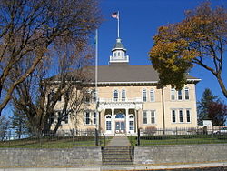 Location of Davenport, Washington
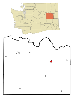
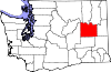
Coordinates: 47°39′4″N 118°9′6″W / 47.65111°N 118.15167°WCoordinates: 47°39′4″N 118°9′6″W / 47.65111°N 118.15167°W Country United States State Washington County Lincoln Area – Total 1.5 sq mi (3.9 km2) – Land 1.5 sq mi (3.9 km2) – Water 0.0 sq mi (0.0 km2) Elevation 2,375 ft (724 m) Population (2000) – Total 1,734 – Density 1,156.0/sq mi (444.6/km2) Time zone Pacific (PST) (UTC-8) – Summer (DST) PDT (UTC-7) ZIP code 99122 Area code(s) 509 FIPS code 53-16795[1] GNIS feature ID 1504329[2] Davenport is a city in Lincoln County, Washington, United States. The population was 1,734 at the 2010 census. It is the county seat of Lincoln County[3].
Contents
History
Davenport was first settled in 1880, and was named in 1882 for resident J.C. Davenport.[4] Davenport was officially incorporated on June 9, 1890.
Geography
Davenport is located at 47°39′4″N 118°9′6″W / 47.65111°N 118.15167°W (47.651157, -118.151627).[5]
According to the United States Census Bureau, the city has a total area of 1.5 square miles (3.9 km²), all of it land.
Demographics
As of the census[1] of 2000, there were 1,730 people, 707 households, and 436 families residing in the city. The population density was 1,143.3 people per square mile (442.4/km²). There were 763 housing units at an average density of 504.3 per square mile (195.1/km²). The racial makeup of the city was 97.17% White, 0.29% African American, 0.98% Native American, 0.29% from other races, and 1.27% from two or more races. Hispanic or Latino of any race were 2.25% of the population. 30.0% were of German, 12.1% American, 10.6% English and 6.2% Irish ancestry according to Census 2000. 98.4% spoke English and 1.6% Spanish as their first language.
There were 707 households out of which 30.8% had children under the age of 18 living with them, 50.1% were married couples living together, 9.2% had a female householder with no husband present, and 38.3% were non-families. 33.8% of all households were made up of individuals and 18.0% had someone living alone who was 65 years of age or older. The average household size was 2.34 and the average family size was 3.01.
In the city the population was spread out with 25.7% under the age of 18, 5.8% from 18 to 24, 24.7% from 25 to 44, 21.7% from 45 to 64, and 22.0% who were 65 years of age or older. The median age was 41 years. For every 100 females there were 85.2 males. For every 100 females age 18 and over, there were 79.7 males.
The median income for a household in the city was $37,900, and the median income for a family was $47,708. Males had a median income of $34,531 versus $21,875 for females. The per capita income for the city was $20,090. About 8.5% of families and 11.2% of the population were below the poverty line, including 12.9% of those under age 18 and 9.9% of those age 65 or over.
Community
School - Davenport Gorillas
Transportation
Davenport is served by the Davenport Municipal Airport.
Climate
Davenport experiences a continental climate (Köppen Dfb).
Climate data for Davenport (1971-2000) Month Jan Feb Mar Apr May Jun Jul Aug Sep Oct Nov Dec Year Average high °F (°C) 31.1
(−0.5)37.3
(2.9)47.5
(8.6)57.2
(14.0)65.8
(18.8)73.3
(22.9)81.9
(27.7)82.8
(28.2)72.8
(22.7)59.1
(15.1)40.7
(4.8)31.5
(−0.3)56.75
(13.75)Daily mean °F (°C) 24.9
(−3.9)30.2
(−1.0)38.0
(3.3)45.0
(7.2)52.6
(11.4)59.2
(15.1)65.8
(18.8)66.3
(19.1)57.3
(14.1)45.8
(7.7)33.7
(0.9)25.3
(−3.7)45.34
(7.41)Average low °F (°C) 18.6
(−7.4)23.0
(−5.0)28.4
(−2.0)32.8
(0.4)39.4
(4.1)45.0
(7.2)49.6
(9.8)49.7
(9.8)41.8
(5.4)32.4
(0.2)26.7
(−2.9)19.0
(−7.2)33.87
(1.04)Precipitation inches (mm) 1.45
(36.8)1.22
(31)1.30
(33)1.02
(25.9)1.41
(35.8)1.03
(26.2)0.78
(19.8)0.54
(13.7)0.65
(16.5)0.88
(22.4)1.90
(48.3)1.93
(49)14.11
(358.4)Source: NOAA (normals, 1971-2000) [6] See also
References
- ^ a b "American FactFinder". United States Census Bureau. http://factfinder.census.gov. Retrieved 2008-01-31.
- ^ "US Board on Geographic Names". United States Geological Survey. 2007-10-25. http://geonames.usgs.gov. Retrieved 2008-01-31.
- ^ "Find a County". National Association of Counties. http://www.naco.org/Counties/Pages/FindACounty.aspx. Retrieved 2011-06-07.
- ^ Majors, Harry M. (1975). Exploring Washington. Van Winkle Publishing Co. p. 106. ISBN 9780918664006. http://books.google.com/books?id=CoWrPQAACAAJ.
- ^ "US Gazetteer files: 2010, 2000, and 1990". United States Census Bureau. 2011-02-12. http://www.census.gov/geo/www/gazetteer/gazette.html. Retrieved 2011-04-23.
- ^ "Climatography of the United States NO.81". National Oceanic and Atmospheric Administration. http://cdo.ncdc.noaa.gov/climatenormals/clim81/WAnorm.pdf. Retrieved January 11, 2011.
External links
Municipalities and communities of Lincoln County, Washington Cities Davenport | Harrington | Sprague
Towns Unincorporated
communitiesCategories:- Cities in Washington (state)
- Populated places in Lincoln County, Washington
- County seats in Washington (state)


Wikimedia Foundation. 2010.