- Washington State Route 900
-
State Route 900 
Route information Auxiliary route of I-90 Defined by RCW 47.17.825 Maintained by WSDOT Length: 16.20 mi[1] (26.07 km) Existed: 1964 – present Major junctions West end:  I-5 in Tukwila
 SR 167 in Renton

 I-405/SR 169 in Renton
East end:  I-90 in Issaquah
Highway system State highways in Washington
Interstate • US • State
Former PSH • 1964 renumbering • Former SR←  US 830
SR 901  →
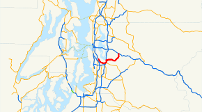
→State Route 900 is a state highway in the state of Washington, USA, getting its number as the westernmost spur of Interstate 90. It extends 16.20 miles (26.07 km) from I-5 in Tukwila east to I-90 in Issaquah.
Contents
Route description
SR 900 begins at the intersection with Ryan Way at I-5 exit 157, near the southeast corner of Boeing Field. It heads south on Martin Luther King Jr. Way (formerly Empire Way), with ramps to and from I-5, before splitting from the alignment of I-5 and heading east into Renton (with a short section in Seattle). It heads into downtown Renton on Sunset Boulevard. At State Route 167, a one-way pair begins, with eastbound SR 900 on Third Street and westbound SR 900 on Second Street. At State Route 515, SR 900 heads northeast on Houser Way (eastbound) and Bronson Way (westbound), and after a block SR 900 east turns north on Mill Avenue to rejoin the westbound side on Bronson Way.
Just before Bronson Way crosses under I-405, SR 900 turns north along the west-side frontage road, Sunset Boulevard. Sunset crosses to the east side of I-405 and then turns east, however SR 900 enters I-405 for a one mile (1.6 km) overlap, exiting once again at Park Ave N. SR 900 turns east onto Park Ave N, which again becomes NE Sunset Blvd, taking SR 900 between the slopes of Cougar Mountain and Squak Mountain to its end at I-90 in Issaquah (though the name changes to Renton-Issaquah Road). Lake Sammamish State Park lies right across I-90 from the end of SR 900.
History
- Before April 1, 1992, SR 900 continued west (compass north) along Martin Luther King, Jr. Way and Rainier Avenue to end at I-90 exit 3. The west end of SR 900 is now milepost 5.93 due to this truncation; the east end is milepost 21.64.
- Before the Lake Washington Floating Bridge was built across Lake Washington in 1940, SR 900 was one of the major roads east from Seattle, taking US 10 and Primary State Highway 2 around the south side of the lake. It had been established by the legislature as a State Highway in 1909,[1] and PSH 2 was completed for through traffic in 1915 (the last section being east of SR 900, through Snoqualmie Pass).[2] The opening of the bridge in 1940 moved US 10/PSH 2 to the direct route, and the old alignment became Alternate US 10 and PSH 2 RE (for Renton). In 1955,[3] Alternate US 10 was dropped, and it became SR 900 in 1964.
Exit list
The entire route is in King County.
Location Mile[1] Destinations Notes Tukwila 0.00 M. L. King Way Continuation beyond Boing Access Road 0.00 Boeing Access Road to Airport Way, East Marginal Way Former SR 181 0.19  I-5 north – Seattle
Interchange 0.65  I-5 south – Portland
Interchange; eastbound exit and westbound entrance Renton 3.97 
 SR 167 (Rainier Avenue) to I-405
4.56  SR 515 (Main Street)
5.40 
 SR 169 south to I-405 – Maple Valley, Enumclaw, Everett, Seattle, Tacoma
Houser Way Bypass Interchange; eastbound exit and westbound entrance 5.62 Sunset Boulevard Northeast 5.62  I-405 south – Tacoma
West end of I-405 overlap; interchange; westbound exit and eastbound entrance 6.52  I-405 north – Everett
East end of I-405 overlap; interchange Issaquah 16.20  I-90 – Seattle, Spokane
Interchange 16.20 Lake Sammamish State Park Continuation beyond I-90 References
External links
State highways in Washington related to I-90  Categories:
- State highways in Washington (state)
- Transportation in King County, Washington
Wikimedia Foundation. 2010.

