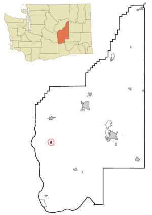
- George, Washington
Infobox Settlement
official_name = George, Washington
settlement_type =City
nickname =
motto =
imagesize =
image_caption =
image_
imagesize =
image_caption =
image_
mapsize =
map_caption =
mapsize1 =
map_caption1 =subdivision_type = Country
subdivision_name =United States
subdivision_type1 = State
subdivision_name1 =Washington
subdivision_type2 = County
subdivision_name2 = Grantgovernment_footnotes =
government_type =
leader_title =
leader_name =
leader_title1 =
leader_name1 =
established_title =
established_date =unit_pref = Imperial
area_footnotes =area_magnitude =
area_total_km2 = 1.6
area_land_km2 = 1.6
area_water_km2 = 0.0
area_total_sq_mi = 0.6
area_land_sq_mi = 0.6
area_water_sq_mi = 0.0population_as_of =
2006
population_footnotes =
population_total = 571
population_density_km2 = 339.5
population_density_sq_mi = 879.2timezone = Pacific (PST)
utc_offset = -8
timezone_DST = PDT
utc_offset_DST = -7
elevation_footnotes =
elevation_m = 374
elevation_ft = 1227
latd = 47 |latm = 4 |lats = 42 |latNS = N
longd = 119 |longm = 51 |longs = 26 |longEW = Wpostal_code_type =
ZIP code s
postal_code = 98824, 98848
area_code = 509
blank_name = FIPS code
blank_info = 53-26455GR|2
blank1_name = GNIS feature ID
blank1_info = 1505105GR|3
website =
footnotes =George is a city in Grant County,
Washington ,United States . The population was 528 at the 2000 census. The town is known for being near theGorge Amphitheatre , sometimes being called, "The Gorge at George".History
George began as a large irrigation district between Quincy and Moses Lake. In the early 1950s, the need for a town to support the local agriculture business was evident, and the
Bureau of Land Management agreed to 339 acres for this purpose. The winning (and only) bid was that of the local pharmacist, Charlie Brown. Brown invested his own money into the venture, and with help from aUniversity of Washington instructor, the town structure was planned. The plan included streets, utilities, etc.When filing the papers for the town with the BLM, Brown decided that the town should be named as a humorous salute to the first President of the United States,
George Washington .The town was officially incorporated on July 4, 1957 at a ceremony including the governor of Washington. [City of George website - history http://www.ci.george.wa.us/history.html]
Demographics
As of the
census GR|2 of 2000, there were 528 people, 141 households, and 106 families residing in the city. Thepopulation density was 879.2 people per square mile (339.8/km²). There were 162 housing units at an average density of 269.8/sq mi (104.2/km²). The racial makeup of the city was 80.11% White, 0.57% Native American, 0.38% Asian, 16.10% from other races, and 2.84% from two or more races. Hispanic or Latino of any race were 60.23% of the population.There were 141 households out of which 49.6% had children under the age of 18 living with them, 58.2% were married couples living together, 6.4% had a female householder with no husband present, and 24.8% were non-families. 18.4% of all households were made up of individuals and 5.7% had someone living alone who was 65 years of age or older. The average household size was 3.74, and the average family size is 4.39. In the city the population was spread out with 37.7% under the age of 18, 16.5% from 18 to 24, 26.9% from 25 to 44, 14.0% from 45 to 64, and 4.9% who were 65 years of age or older. The median age was 23 years. For every 100 females there were 118.2 males. For every 100 females age 18 and over, there were 140.1 males.The median income for a household in the city was $21,181, and the median income for a family was $23,571. Males had a median income of $21,667 versus $13,875 for females. The
per capita income for the city was $7,779. About 33.0% of families and 36.2% of the population were below thepoverty line , including 46.8% of those under age 18 and 14.0% of those age 65 or over.References
External links
* [http://www.ci.george.wa.us/ City of George]
Wikimedia Foundation. 2010.


