- U.S. Route 97 in Washington
-
This article is about the section of U.S. Route 97 in Washington. For the entire length of the highway, see U.S. Route 97.
U.S. Route 97
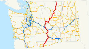
US 97 highlighted in red.Route information Defined by RCW 47.17.155 Maintained by WSDOT Length: 321.62 mi[2] (517.60 km) Existed: 1926[1] – present Major junctions South end:  US 97 at the Oregon state line in Maryhill
 SR 14 in Maryhill
 SR 22 in Toppenish

 I-82 / US 12 in Union Gap
US 12 in Yakima
 I-90 near Ellensburg
 US 2 near Peshastin
 SR 28 in East Wenatchee
 SR 17 near Brewster
 SR 20 near Okanogan
North end:  BC 97 at the Canadian border near Oroville
Highway system United States Numbered Highways
List • Bannered • Divided • ReplacedState highways in Washington
Interstate • US • State
Former PSH • 1964 renumbering • Former SR←  SR 96
SR 96SR 99  →
→In the U.S. state of Washington, U.S. Route 97 (US 97) is a 322-mile (518 km) route which traverses from the Oregon state line at the northern end of the Sam Hill Memorial Bridge in Maryhill, north to the Canadian border in Okanogan County near Oroville. The highway serves major cities such as Goldendale, Yakima, Ellensburg and Wenatchee before continuing towards the Alaska Highway at the Yukon border as British Columbia Highway 97. Along the length of the roadway, US 97 is concurrent with State Route 14 (SR 14) in Maryhill, Interstate 82 (I-82) and US 12 between Union Gap and Ellensburg, I-90 briefly in Ellensburg, US 2 between Peshastin and rural Douglas County and SR 20 near Omak. An alternate route connects the highway with Chelan.
The first segment of what is now US 97 in Washington to be included in the state highway system was a road extending from Wenatchee to Twisp, designated in 1897. Since, four early highways formed the modern route of the roadway: State Road 8, State Road 3, State Road 2 and State Road 10, all signed in 1923. The United States Numbered Highways were established in 1926 and US 97 was co-signed with all four state roads, including two concurrencies with US 410 and US 10. The state roads became Primary state highways in 1937, keeping their numbers from the previous system and US 10 was moved south in 1940 and its original alignment, including the concurrency, became US 2 in 1946. The Sam Hill Memorial Bridge, originally named the Biggs Rapids Bridge, was first opened on November 1, 1962, but the river has been crossed by a ferry at the same location since the early 1920s. During the 1964 highway renumbering, all four highways were replaced by US 97 and in 1956, the Interstate Highway System was established, including two highways (I-82 and I-90) concurrent with US 97. US 12 replaced US 410 during its extension west in 1967 and US 97 was moved across the Columbia River in Chelan County, establishing US 97 Alternate and decommissioning SR 151 in 1987. Until 2006, US 197 was co-signed with SR 14 between Dallesport and Maryhill. The bridge deck was replaced between 2007 and 2009 and the bridge was closed in 2008. Five other minor projects, such as repavings and sidewalk additions, have already been completed, but eight projects have yet to be completed.
Contents
Route description
US 97 is a major highway in Washington that spans 321.61-mile (517.581 km) and consists of mostly two lanes;[2] it is undivided except for the sections that are in urban areas, such as Wenatchee and concurrent with Interstate 82 (I-82) and I-90.[3][4] The entire route from the Oregon state line to the Canadian border is part of the National Highway System, a system of roadways considered important to the nation's economy, defense and mobility.[5][6] At the southern terminus of the I-82 – US 12 concurrency in Union Gap, US 97 had an estimated daily average of 20,000 motorists in 2007, making it both the busiest segment of the highway in Washington and the fifth busiest segment of U.S. routes in Washington.[7] The busiest segment of US 97 in 1970 was at Main Street in Selah, with a daily average of 17,100 motorists.[8]
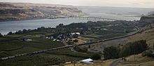 An aerial view of Maryhill, the first community on US 97, where the highway travels over the Columbia River on the Sam Hill Memorial Bridge, visible in the background.
US 97 begins at the Oregon state line over the Columbia River on the Sam Hill Memorial Bridge. After exiting the bridge, the highway enters Maryhill, passes the Maryhill State Park and crosses railroad tracks on the Vancouver–Pasco route operated by BNSF Railway.[9] From the crossing, the roadway becomes briefly concurrent with State Route 14 (SR 14) west for 0.42 miles (0.68 km) before turning north to intersect SR 14 Spur (via a couplet) and leaving the Maryhill area.[3][10]
From Maryhill, the road curves northeast and later north to pass Centerville and bypass Goldendale to intersect SR 142. US 97 then turns northeast through Brooks Memorial State Park and entering the Yakama Indian Reservation passes over Satus Pass then coming out of the Cascades into the Yakima Valley passes the Toppenish National Wildlife Refuge and Toppenish, where it intersects SR 22 and Fort Road,[11] which was SR 220 until 1991.[12] After leaving Toppenish in a northwestern direction, the highway parallels the Tacoma–Pasco route of the BNSF Railway and the Interstate 82 (I-82) – US 12 concurrency briefly past Wapato and some minor roads to also parallel the Yakima River and enter Union Gap,[13][14][15] where the roadway joins the I-82 and US 12 concurrency.[3][9][16]

From the interchange in which US 97 joins the I-82 / US 12, numbered exit 37,[16] the freeway interchanges with many minor streets in Union Gap and some major highways, including a state route, in Yakima, including Valley Mall Boulevard at exit 36,[17] SR 24 and Nob Hill Boulevard at exit 34,[18] Terrace Heights Way and Yakima Avenue at exit 33;[19] at exit 31, US 12 ends its 31.35-mile (50.45 km) long concurrency at the southern terminus of SR 823.[2][20] After leaving Yakima, the highway enters Selah and interchanges with SR 823 and Rest Haven Road and then later leaves the city after interchanging Selah Road to cross Selah Creek on the Fred G. Redmon Bridge.[21][22] Approaching Ellensburg, the roadway interchanges with SR 821 at exit 26,[23] Military Road at exit 11 and the northern end of SR 821 at exit 3 before entering Ellensburg.[24][25] I-82 later ends its 37.81-mile (60.85 km) concurrency and route at I-90, were a brief concurrency begins.[2][3][26]
The I-90 concurrency begins at exit 110, which is a trumpet interchange.[27] Then, I-90 / US 97 interchanges Canyon Road at exit 109 and then US 97 leaves the 19.73-mile (31.75 km) concurrency at exit 106.[2][28][29][30] From I-90, the highway turns northwest, passing SR 10 southeast of Thorp, a railroad track owned by BNSF Railway,[9] and SR 970 in Virden to Blewett Pass, where US 97 crosses the Cascades. At Peshastin, the roadway starts its 27.98-mile (45.03 km) concurrency with US 2 at a diamond interchange.[2][3][31]
From Peshastin, US 2 / US 97 parallels another BNSF route and passes Dryden and Cashmere before entering Wenatchee and intersecting Washington State Route 285 and later US 97 Alternate.[32] After the intersection with US 97 Alternate, which is actually a partial cloverleaf interchange,[33] the roadway crosses the Columbia River on the Richard Odabashian Bridge into East Wenatchee, where it intersects SR 28, turns north and starts to parallel the Wenatchee—Oroville route of the Cascade and Columbia River Railroad.[9] After paralleling the Columbia River, US 2 leaves the concurrency at Orondo. The road continues north and later east along the Columbia River from Orondo to Chelan Falls, where US 97 once again crosses the Columbia River, on the Beebe Bridge and then intersects SR 150. After leaving Chelan Falls, the highway follows the Columbia River and passes the northern terminus of US 97 Alternate, which goes west to Chelan, and continues north to intersect SR 153 south of Pateros. After leaving the city, the roadway travels northeast to Brewster, where it intersects SR 173.[3]
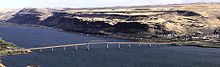
 US 97 – SR 20 seen through Okanogan.
After leaving Brewster, US 97 crosses the Okanogan River and passes Anderson Field to intersect SR 17 north of Fort Okanogan State Park. From SR 17, the highway parallels the Okanogan River north past Monse and Malott to Okanogan, where the roadway enters the Colville Indian Reservation and starts a 28.65-mile (46.11 km) long concurrency with SR 20.[2] From the beginning of the concurrency, the road crosses a railroad and intersects SR 155.[34] US 97 / SR 20 then crosses over SR 155 on a bridge and crosses the Okanogan River.[34]
After the crossing, the roadway leaves Omak, along with the Colville Indian Reservation and intersects SR 215. From SR 215, the highway continues north past North Omak and Riverside to cross the Okanogan River again and enter Tonasket, where SR 20 leaves the concurrency. After leaving Tonasket, the road continues north along the Okanogan River to Oroville, the last major community on US 97 before the border. The Okanogan River becomes Osoyoos Lake at this point and the highway parallels the lake to the Canadian border, where the roadway becomes British Columbia Highway 97 (BC 97) and continues north towards Alaska.[3]
History
Late 19th and early 20th centuries
The first segment of US 97 to be included in Washington's state highway system was a roadway extending from Wenatchee to Twisp, although the US 97 segment ended in Pateros, established in 1897.[35][36] In 1905, another road from Pateros to Okanogan was added to the system,[37] which would be extended to the Canadian border in 1907. That roadway from Wenatchee to Canada, was named the Wenatchee-Oroville Road and numbered State Road 10. A different road, located along the Oregon state line on the Columbia River, was established as State Road 8, the Columbia River Road and ran north from Maryhill to Goldendale.[38]
Six years later, in 1913, State Road 7 was created on a Virden–Wenatchee route.[35] The Inland Empire Highway was established in 1915 and the section it overlapped with present-day US 97 ran from Buena northwest to Ellensburg.[39] State Road 2 replaced State Road 7 in 1919 and a branch, the Southern Division of the Sunset Highway, was established in 1919 and ran south from State Road 2 at Virden to Ellensburg.[40]
During the early 1920s, a ferry was established over the Columbia River between Biggs Junction, Oregon and Maryhill.[41] State Road 8 between Goldendale and Buena was established in 1923.[42] US 97 was established along with the rest of the U.S. routes in 1926, including US 10 and US 410, which were concurrent with US 97.[1] All state roads became Primary state highways in 1937 and they kept their numbers; a branch of Primary State Highway 8 (PSH 8) was also established, connecting the Maryhill ferry to PSH 8 in Maryhill.[43] Another concurrency was added in 1946, when US 2 was extended west, co-signed with US 97 between Peshastin and Wenatchee.[44][45]
Late 20th century
 A panoramic view of the Sam Hill Memorial Bridge, which carries US 97 over the Columbia River into Oregon. The bridge opened on 1 November 1962 as the Biggs Rapids Bridge and the deck was replaced between Fall 2007 and March 2009.
On 29 June 1956, President Dwight D. Eisenhower signed the Federal Aid Highway Act of 1956 into law, establishing a system of freeways that would later become the Interstate Highway System.[46][47] Included in the system were Interstate 82 (I-82) and I-90, which were to be concurrent with US 97.[48] The Biggs Rapids Bridge (later renamed to the Sam Hill Memorial Bridge) was opened on 1 November 1962, replacing the ferry that had been operating on the route since the early 1920s.[41][49] A new system of highways was introduced in 1964 and ultimately caused US 97 to replace the Primary state highways.[50]
US 410 was replaced by a western extension of US 12 in 1967, when the highway's western terminus was moved to Aberdeen.[51][52] In 1973, a segment of US 97 between Selah and Ellensburg was realigned east away from the Yakima River and onto I-82, while the former route became SR 821.[53] Between US 97 / US 10, which would later be decommissioned by 1970,[54] near Thorp and US 97 in Virden, there was a SR 131.[55] In 1975, to reduce the SR 10 concurrency, US 97 replaced SR 131 and the old route became SR 10 and SR 970.[56] SR 131 would later be routed on another route in the Randle area in 1991.[12] Within Selah, US 97 was also moved onto I-82 away from the city, so the old route became SR 823 in 1984.[57] Prior to 1987, US 97 ran on the west side of the Columbia River between Wenatchee and Chelan, while SR 151 ran on the east side.[58] US 97 was moved onto SR 151 in 1987 and the old US 97 became US 97 Alternate.[59]
Early 21st century
Beginning in 2006, the Washington State Department of Transportation (WSDOT) has completed five construction projects on the US 97 corridor, ranging from a bridge deck replacement in Maryhill to repaving the roadway between Oroville area and Canada.[60] Construction on a three-part project to install guardrails on dangerous portions of the highway began on May 16, 2006.[61] The project was finished on 17 August 2006 and improved a 32-mile (51 km) segment near Blewett Pass, a 18-mile (29 km) section in the Colville Indian Reservation and a 20-mile (32.19 km) segment between Riverside and Oroville.[61][62]
Prior to 5 October 2006, US 197, an auxiliary route of US 97, ended at US 97, co-signed with SR 14, in Maryhill. On 5 October, the American Association of State Highway and Transportation Officials (AASHTO) decommissioned US 197 between Dallesport and Maryhill.[63] Between 29 May and 28 September 2007, WSDOT repaved the roadway between Cordell, located south of Oroville, and the Canadian border.[64][65] In July 2008, WSDOT completed installing guardrails on the road in Klickitat County.[66][67] Between 11 August and December 5, 2008, WSDOT added sidewalks and illumination along a 0.59-mile (0.95 km) long stretch of the highway between Main Street and SR 173 in Brewster.[68][69][70]
Since the opening of the Sam Hill Memorial Bridge in 1962, the bridge has used a lightweight concrete and asphalt bridge deck.[41][49] Now, the bridge is a heavily used truck route and requires a heavy concrete deck.[41] In late 2006, a replacement project was planned and the estimated $16 million USD cost was split between the governments of Washington and Oregon.[71] The whole bridge was replaced by WSDOT, including the Oregon side.[72] The project was accelerated to Fall 2007,[71] but the bridge wasn't closed until 2 January 2008.[73][74] During construction on 15 January, approximately 8:00 (PST), a worker was seriously injured after an excavator fell into the Columbia River.[75][76] After the area was cleaned, the project resumed on 23 January and a worker died after falling off the bridge on February 26.[77][78] By April, half of the new deck was complete and the bridge was reopened on May 19, at 18:00 (PST).[79][80] Although the bridge was reopened, it was once again closed on 3 September for more repairs.[81][82][83] The bridge was reopened on 24 December and all roadwork was completed on 23 March 2009.[84][85][86]
Future projects
As of 2009, eight projects on the corridor have not been completed yet and some are currently under construction.[87] Between 27 April and 30 June,[88] completed the second phase of emergency flood repairs to US 97 at Blewett Pass because the 5 – 6 January floods washed out the roadway. The third and final phase is set to begin on August 17.[89][90] The Janis Bridge was first constructed and completed in 1957 and on 15 June 2009, a construction project to the rehabilitate the bridge deck begam. Construction will cease on 27 July.[91][92] On 22 June, construction began on a project to install a new traffic signal at the SR 155 intersection in Okanogan, two variable-message signs and two traffic cameras near the Canadian border.[93][94] On 27 July, WSDOT will start to fix an unstable slope north of Blewett Pass, 8 miles (13 km) south of the US 2 intersection.[95][96] Another project set to begin on 27 July to fix an unstable slope on US 97 near Blewett Pass.[97][98] WSDOT will add a passing lane on the highway at Blewett Pass in summer 2010.[99][100] The bridge over Satus Creek, located within the Yakima Indian Reservation in Klickitat County will be replaced in 2010.[101][102] A repaving project between Orondo and Chelan Falls has been put on hold until 2016, originally scheduled for 2010.[103][104]
Bannered routes
Maryhill couplet
At the intersection with State Route 14 Spur (SR 14 Spur) in Maryhill, US 97 becomes split into two different roadways and the 0.09-mile (0.14 km) long southbound road that intersects the spur is identified as a couplet.[2][10] The busiest section of the US 97 couplet in 2007 was at the US 97 intersection, with a daily average of 2,000 motorists.[7]
Alternate route

U.S. Route 97 Alternate
Location: Wenatchee — Chelan Existed: 1987–present US 97 Alternate is a 39.35-mile (63.33 km) long alternate route that extends from the US 97 / US 2 concurrency north of Wenatchee along the west side of the Columbia River to US 97 east of Chelan, completely in Chelan County.[2] The highway begins at a partial cloverleaf interchange with US 97 / US 2 north of Wenatchee and west of the Richard Odabashian Bridge over the Columbia River.[33] After leaving the interchange, the roadway parallels the eastern boundary of the Wenatchee National Forest to cross the Entiat River and pass Entiat before intersecting SR 971 twice, the second time being on the southern shores of Lake Chelan. The road continues east across the Chelan River into Chelan as various streets, such as Woodin Avenue, Webster Avenue and Saunders Street before intersecting SR 150, leaving Chelan, passing Lake Chelan Airport and ending at US 97.[105] In 1897, US 97 Alternate was a part of a Wenatchee–Twisp highway.[36] That highway became a part of US 97 in 1926 and later US 97 Alternate in 1987 when US 97 was moved east of the river over SR 151.[1][58][59] The busiest section of US 97 Alternate in 2007 was north of the US 97 / US 2 interchange, with a daily average of 9,700 motorists.[7]
Orondo spur

U.S. Route 97 SpurLocation: Orondo US 97 Spur is a 0.26-mile (0.42 km) long spur route that connects US 97 north of the terminus of the US 2 concurrency to US 2 east of the end of the concurrency, completely located in Orondo, a community in Douglas County.[2][106] The busiest section of US 97 Spur in 2007 was at the US 97 intersection, with a daily average of 250 motorists.[7]
Major intersections
For a full list of interchanges on the I-82 overlap, see Interstate 82.
County Location Mile[2] #[26][30] Destinations Notes Klickitat Maryhill 0.00 Sam Hill Memorial Bridge over the Columbia River 2.38 SR 14 east – Paterson, KennewickSouth end of SR 14 overlap 2.80 SR 14 west (Lewis and Clark Highway) – Lyle, Camas, VancouverNorth end of SR 14 overlap Goldendale 13.16  SR 142 west – Goldendale
Yakima 61.30 SR 22 – Mabton, Prosser61.84 Fort Road – Fort Simcoe State Park Former SR 220 75.99 Main Street – Union Gap Interchange; northbound exit and southbound entrance 76.18 37 I-82 east / US 12 east – Richland, PendletonInterchange; south end of I-82/US 12 overlap; southbound exit and northbound entrance Yakima 81.76 31 US 12 west – Naches, White PassInterchange; north end of US 12 overlap Kittitas 113.99 110 I-90 east – Vantage, SpokaneInterchange; north end of I-82 overlap; south end of I-90 overlap Ellensburg 114.50 109 Canyon Road – Ellensburg Interchange 118.80 106 I-90 west – SeattleInterchange; north end of I-90 overlap 121.51  SR 10 west – Cle Elum
134.72  SR 970 west to I-90 – Cle Elum, Seattle
Chelan 170.05 US 2 west – Leavenworth, Stevens Pass, EverettSouth end of US 2 overlap 184.31  SR 285 south – Wenatchee
Interchange 184.57 
US 97 Alt. north – Entiat, ChelanInterchange Douglas 193.16 SR 28 east to I-90 – East Wenatchee, Quincy198.16 US 2 east – Waterville, Davenport, SpokaneNorth end of US 2 overlap Chelan 220.26  SR 150 west – Chelan Falls, Chelan, Manson
225.31
US 97 Alt. south – Chelan, EntiatOkanogan 238.54  SR 153 north to SR 20 – Twisp, Winthrop
Brewster 245.57  SR 173 south – Brewster, Bridgeport
250.36 SR 17 south271.33 SR 20 west – Okanogan, Twisp, WinthropSouth end of SR 20 overlap Omak 276.39  SR 155 south – Omak, Grand Coulee Dam
277.47 

 SR 215 south / SR 20 Bus. west – Omak
Tonasket 299.97 SR 20 east – RepublicNorth end of SR 20 overlap 321.62 Canadian border Continues as British Columbia Highway 97 References
- ^ a b c Oklahoma Department of Transportation (1926-11-11). United States System of Highways (Map). http://www.okladot.state.ok.us/hqdiv/p-r-div/maps/misc-maps/1926us.pdf. Retrieved 1 July 2009.
- ^ a b c d e f g h i j k Washington State Department of Transportation (2006). "State Highway Log: Planning Report, SR 2 to SR 971". http://www.wsdot.wa.gov/mapsdata/TDO/PDF_and_ZIP_Files/HwyLog2006.pdf. Retrieved 4 July 2009.
- ^ a b c d e f g Google, Inc. Google Maps – U.S. Route 97 (Map). Cartography by Google, Inc. http://maps.google.com/maps?f=d&source=s_d&saddr=US-97&daddr=46.443535,-120.434875+to:US-97&hl=en&geocode=FXL1uAIdsDDM-A%3B%3BFdiu6wId7Cbh-A&mra=dpe&mrcr=0&mrsp=1&sz=9&via=1&sll=46.679594,-119.945984&sspn=1.368055,2.463684&ie=UTF8&ll=47.405785,-119.86084&spn=5.398582,9.854736&z=7. Retrieved 4 July 2009.
- ^ Washington State Department of Transportation (2008). Washington State Highways, 2008–2009 (Map). 1:842,000. Cartography by United States Geological Survey (2008–09 edition ed.). Section F8. http://www.wsdot.wa.gov/NR/rdonlyres/87105CAD-83A9-49A7-80F3-5719637C1E2D/0/FrontMapBig.pdf. Retrieved 5 July 2009.
- ^ "The National Highway System". Federal Highway Administration. 27 August 2008. http://www.fhwa.dot.gov/planning/nhs/. Retrieved 1 July 2009.
- ^ United States Department of Transportation, Federal Highway Administration (2004). National Highway System: Washington (Map). http://www.fhwa.dot.gov/planning/nhs/maps/wa/wa_washington.pdf. Retrieved 1 July 2009.
- ^ a b c d Washington State Department of Transportation (2007). "2007 Annual Traffic Report". http://www.wsdot.wa.gov/mapsdata/tdo/PDF_and_ZIP_Files/Annual_Traffic_Report_2007.pdf. Retrieved 8 July 2009.
- ^ Washington State Highway Commission, Department of Highways (1970). "Annual Traffic Report, 1970". Washington State Department of Transportation. http://www.wsdot.wa.gov/mapsdata/tdo/PDF_and_ZIP_Files/1970_ATR.pdf. Retrieved 8 July 2009.
- ^ a b c d Washington State Department of Transportation (2008). Washington State Rail System (Map). Cartography by United States Geological Survey. http://www.wsdot.wa.gov/NR/rdonlyres/8CFBC47D-3549-4CB9-9DE6-14CE9739671F/0/RailSystemMap_Sept2008_update.pdf. Retrieved 4 July 2009.
- ^ a b Washington State Department of Transportation (17 September 2004). "SR 14; Junction SR 14 Spur / SR 97 / SR 97 Couplet". http://www.wsdot.wa.gov/mapsdata/tdo/Interchange/pdfs/SR014/014X100.pdf. Retrieved 4 July 2009.
- ^ Washington State Department of Transportation (2 June 2009). "SR 97; Junction SR 22". http://www.wsdot.wa.gov/mapsdata/tdo/Interchange/pdfs/SR097/097X061.pdf. Retrieved 4 July 2009.
- ^ a b Washington House of Representatives (1991). "Chapter 342, Laws of 1991: State Highway Routes — Revisons To (House Bill 5801)". Washington State Legislature. http://www.leg.wa.gov/pub/billinfo/1991-92/Htm/Bills/Session%20Law%201991/5801.SL.htm. Retrieved 4 July 2009.
- ^ Washington State Department of Transportation (22 April 1992). "SR 97; Junction East McDonal Road". http://www.wsdot.wa.gov/mapsdata/tdo/Interchange/pdfs/SR097/097X063.pdf. Retrieved 5 July 2009.
- ^ Washington State Department of Transportation (2 October 2001). "SR 97; Junction Wapato Road". http://www.wsdot.wa.gov/mapsdata/tdo/Interchange/pdfs/SR097/097X069.pdf. Retrieved 5 July 2009.
- ^ Washington State Department of Transportation (22 April 1992). "SR 97; Junction Frontage Road / Lateral 1 Road". http://www.wsdot.wa.gov/mapsdata/tdo/Interchange/pdfs/SR097/097X071.pdf. Retrieved 5 July 2009.
- ^ a b Washington State Department of Transportation (25 June 2009). "SR 82 – Exit 37; Junction SR 97". http://www.wsdot.wa.gov/mapsdata/tdo/Interchange/pdfs/SR082/082X037.pdf. Retrieved 4 July 2009.
- ^ Washington State Department of Transportation (2 February 2007). "SR 82 — Exit 36; Junction Valley Mall Boulevard". http://www.wsdot.wa.gov/mapsdata/tdo/Interchange/pdfs/SR082/082X036.pdf. Retrieved 5 July 2009.
- ^ Washington State Department of Transportation (12 February 2008). "SR 82 — Exit 34; Junction SR 24 / Nob Hill Boulevard". http://www.wsdot.wa.gov/mapsdata/tdo/Interchange/pdfs/SR082/082X034.pdf. Retrieved 5 July 2009.
- ^ Washington State Department of Transportation (5 October 2004). "SR 82 — Exit 33; Terrace Heights Way / East Yakima Avenue". http://www.wsdot.wa.gov/mapsdata/tdo/Interchange/pdfs/SR082/082X033.pdf. Retrieved 5 July 2009.
- ^ Washington State Department of Transportation (5 October 2004). "SR 82 — Exit 31; Junction SR 12 / SR 823 / North First Street". http://www.wsdot.wa.gov/mapsdata/tdo/Interchange/pdfs/SR082/082X031.pdf. Retrieved 5 July 2009.
- ^ Washington State Department of Transportation (5 October 2004). "SR 82 — Exit 30; Junction SR 823 / Rest Haven Road". http://www.wsdot.wa.gov/mapsdata/tdo/Interchange/pdfs/SR082/082X030.pdf. Retrieved 5 July 2009.
- ^ Washington State Department of Transportation (24 June 1992). "SR 82 — Exit 29; Junction East Selah Road". http://www.wsdot.wa.gov/mapsdata/tdo/Interchange/pdfs/SR082/082X029.pdf. Retrieved 5 July 2009.
- ^ Washington State Department of Transportation (25 June 2009). "SR 82 — Exit 26; Junction SR 821 / Firing Center Road". http://www.wsdot.wa.gov/mapsdata/tdo/Interchange/pdfs/SR082/082X026.pdf. Retrieved 5 July 2009.
- ^ Washington State Department of Transportation (24 June 1992). "SR 82 — Exit 11; Junction Military Road". http://www.wsdot.wa.gov/mapsdata/tdo/Interchange/pdfs/SR082/082X011.pdf. Retrieved 5 July 2009.
- ^ Washington State Department of Transportation (25 October 2007). "SR 82 — Exit 3; Junction SR 821 / Thrall Road". http://www.wsdot.wa.gov/mapsdata/tdo/Interchange/pdfs/SR082/082X003.pdf. Retrieved 5 July 2009.
- ^ a b Washington State Department of Transportation. "Interstate Guide: Interstate 82 west to east; Interstate 82 Ellensburg to east of Zillah". http://www.wsdot.wa.gov/Traffic/InterstateGuide/I82_EllensbToEZillah.htm. Retrieved 5 July 2009.
- ^ Washington State Department of Transportation (4 June 2009). "SR 90 — Exit 110; Junction SR 82". http://www.wsdot.wa.gov/mapsdata/tdo/Interchange/pdfs/SR090/090X110.pdf. Retrieved 5 July 2009.
- ^ Washington State Department of Transportation (10 October 2004). "SR 90 — Exit 109; Junction South Main Street / Canyon Road". http://www.wsdot.wa.gov/mapsdata/tdo/Interchange/pdfs/SR090/090X109.pdf. Retrieved 5 July 2009.
- ^ Washington State Department of Transportation (1 March 1995). "SR 90 — Exit 106; Junction SR 97 / Throp Highway". http://www.wsdot.wa.gov/mapsdata/tdo/Interchange/pdfs/SR090/090X106.pdf. Retrieved 5 July 2009.
- ^ a b Washington State Department of Transportation. "Interstate Guide: Interstate 90 west to east; I-90 west of Cle Elum to east of George". http://www.wsdot.wa.gov/Traffic/InterstateGuide/i90/I90_WCleElumToEastGeo.htm. Retrieved 5 July 2009.
- ^ Washington State Department of Transportation (7 April 2009). "SR 2; Junction SR 97 / Jeske Road". http://www.wsdot.wa.gov/mapsdata/tdo/Interchange/pdfs/SR002/002X104.pdf. Retrieved 5 July 2009.
- ^ Washington State Department of Transportation (9 February 2007). "SR 2 / SR 97; Junction SR 285". http://www.wsdot.wa.gov/mapsdata/tdo/Interchange/pdfs/SR002/002X118.pdf. Retrieved 5 July 2009.
- ^ a b Washington State Department of Transportation (10 April 2005). "SR 2 / SR 97; Junction SR 97 Alternate Route (AR)". http://www.wsdot.wa.gov/mapsdata/tdo/Interchange/pdfs/SR002/002X119.pdf. Retrieved 5 July 2009.
- ^ a b Washington State Department of Transportation (15 March 1993). "SR 97; Junction SR 155". http://www.wsdot.wa.gov/mapsdata/tdo/Interchange/pdfs/SR097/097X291.pdf. Retrieved 5 July 2009.
- ^ a b Washington State Department of Transportation (1893 – 1935). State Roads As Established by Legislature, 1893 to 1935 (Map). http://web.archive.org/web/20051106090227/http://www.wsdot.wa.gov/research/History/stateroads1893-1935.pdf. Retrieved 7 July 2009.
- ^ a b Washington State Legislature (18 March 1897). "Chapter 115". Session Laws of the State of Washington. Session Laws of the State of Washington (1897 ed.). Olympia, Washington: Washington State Legislature. p. 481. http://books.google.com/?id=2MY4AAAAIAAJ. Retrieved 7 July 2009. "An act to provide for the establishment and maintenance of a state road along the bank of the Columbia river from the town of Wenatchee, in Kittitas county, thence northerly on the west bank of said Columbia river via the bridge of said Wenatchee river (the same formerly being a ferry) to the mouth of the Methow river; thence along the west bank of the Methow river to the mouth of the Twisp river, in the county of Okanogan. –Approved March 18, 1897"
- ^ Washington State Legislature (1905-03-13). "Chapter 174". Session Laws of the State of Washington. Session Laws of the State of Washington (1905 ed.). Olympia, Washington: Washington State Legislature. p. 355. http://books.google.com/?id=R8g4AAAAIAAJ. Retrieved 7 July 2009.
- ^ Washington State Legislature (13 March 1907). "Chapter 151: Providing for the Establishment, Construction and Maintenance of State Roads and Making Appropriations For Certain State Roads". Session Laws of the State of Washington. Session Laws of the State of Washington (1907 ed.). Olympia, Washington: Washington State Legislature. pp. 310–311. http://books.google.com/?id=Isk4AAAAIAAJ. Retrieved 7 July 2009. "State Road No. 8, or the Columbia River road: This road shall begin at the town of Washougal in Clarke county, Washington, and run thence over the line as surveyed for such state road through Clarke and Skamania counties, and thence over the most practicable route to the town of Goldendale, in Klickitat county; State Road No. 10, or the Wenatchee-Oroville road: This road shall begin at the lower bridge on the Wenatchee river in Chelan county, Washington, and shall run thence over the present constructed state road to the forty-eight mile post; thence by the most practicable route to the town of Pateros, in Okanogan county; thence over the present constructed county road as nearly as practicable through the towns of Brewster and Alma, and thence by the most practicable route to the north line of Okanogan county, Washington."
- ^ Washington State Legislature (19 March 1915). "Chapter 164: Classification of Public Highways". Session Laws of the State of Washington. Session Laws of the State of Washington (1915 ed.). Olympia, Washington: Washington State Legislature. p. 485. http://books.google.com/?id=w7w4AAAAIAAJ. Retrieved 7 July 2009. "Section 5878-2b. A primary state highway is established as follows: A highway connecting with the Sunset Highway at or in the vicinity of the city of Ellensburg; thence by the way of North Yakima, Kennewick, Pasco, Walla Walla, Dayton, crossing the Snake river in the vicinity of Central Ferry, Colfax, Rosalia, Spokane, Deer Park, Loon Lake, Colville, to the international boundary line at Laurier, which shall be known as the Inland Empire Highway."
- ^ Washington State Legislature (14 March 1919). "Chapter 110". Session Laws of the State of Washington. Session Laws of the State of Washington (1919 ed.). Olympia, Washington: Washington State Legislature. p. 267. http://books.google.com/?id=t704AAAAIAAJ. Retrieved 7 July 2009. "Section 15. A primary state highway is established as follows: A highway starting from a connection with the Sunset Highway at Ellensburg; thence by the most feasible route (heretofore the Sunset Highway) to the Columbia River near Vantage; crossing the same and continuing thence northeasterly by the most feasible route ('heretofore the Sunset Highway) to Quincy; thence by the most feasible route (heretofore the North Central Highway) through Ephrata, Krupp, Odessa, and Harrington to a junction with the Sunset Highway at Davenport, to be known as the North Central Highway."
- ^ a b c d Priscilla Long (11 June 2006). "Biggs Rapids/Sam Hill Memorial Bridge, spanning the Columbia at Maryhill, opens on November 1, 1962.". HistoryLink. http://www.historylink.org/index.cfm?DisplayPage=output.cfm&file_id=7803. Retrieved 7 July 2009.
- ^ Washington State Legislature (19 March 1923). "Chapter 185: Primary and Secondary Highways". Session Laws of the State of Washington. Session Laws of the State of Washington (1923 ed.). Olympia, Washington. pp. 628–630. http://books.google.com/?id=G784AAAAIAAJ. Retrieved 7 July 2009. "SEC. 2. A primary state highway, to be known as State Road No. 2 or the Sunset Highway, is established as follows: Beginning at the City of Seattle; thence by the most feasible route in an easterly direction through the cities of Renton, North Bend, Cle Elum, Wenatchee, Waterville, Davenport and Spokane to the Washington-Idaho state line; SEC. 7. A primary state highway, to be known as State Road No. 8 or the North Bank Highway, is established as follows: Beginning at Vancouver, in Clarke County, thence by the most feasible route in an easterly direction through Stevenson, Underwood, Lyle, Maryhill; thence in a northerly direction through Goldendale to a connection with State Road No. 3 at or in the vicinity of Buena in Yakima County; SEC. 9. A primary state highway, to be known as State Road No. 10 or the Chelan-Okanogan State Highway, is established as follows: Beginning at Quincy in Grant County; thence in a northwesterly direction to a connection with the Sunset Highway at the bridge over the Columbia River at Wenatchee; thence over the route of the Sunset Highway to Orondo; thence northeasterly through Chelan Falls, Okanogan and Oroville to the international boundary line."
- ^ Washington State Legislature (17 March 1937). "Chapter 190: Establishment of Primary State Highways". Session Laws of the State of Washington. Session Laws of the State of Washington (1937 ed.). Olympia, Washington: Washington State Legislature. pp. 934–935; 937–939. http://books.google.com/?id=dcQ4AAAAIAAJ. Retrieved 7 July 2009. "SEC. 2. A primary state highway to be known as Primary State Highway No. 2, or the Sunset Highway, is hereby established according to description as follows: Beginning at Seattle in King county, thence in an easterly direction by the most feasible route by way of Renton, Snoqualmie Pass, Cle Elum, Blewett Pass, Wenatchee, Waterville, Wilbur, Davenport and Spokane to the Washington-Idaho boundary line; also beginning at Seattle in King county, thence in an easterly direction by the most feasible route to the north of Lake Washington to a junction with Primary State Highway No. 2, as herein described, in the vicinity west of Snoqualmie Pass; also beginning at Almira, on Primary State Highway No. 2, as herein described, thence in a northerly direction by the most feasible route to the Grand Coulee Dam; SEC. 3. A primary state highway to be known as Primary State Highway No. 3, or the Inland Empire Highway, is hereby established according to description as follows: Beginning at a junction with Primary State Highway No. 2 in the vicinity east of Cle Elum, thence southeasterly by the most feasible route by way of Ellensburg, Yakima, Pasco and Wallula to Walla Walla, thence in a northerly direction by the most feasible route by way of Dayton, Dodge, Colfax, Rosalia, Spokane and Colville to the international boundary line in the vicinity of Laurier; SEC. 8. A primary state highway to be known as Primary State Highway No. 8, or the Evergreen Highway, is hereby established according to description as follows: Beginning at Vancouver on Primary State Highway No. 1, thence in an easterly direction by the most feasible route by way of Stevenson to Goldendale, thence in a northeasterly directioin [sic] by the most feasible route by way of Satus Pass to a junction with Primary State Highway No. 3, southeast of Yakima; also beginning at a junction with Primary State Highway No. 8, as herein described, in the vicinity of Maryhill, thence in a southerly direction by the most feasible route to the ferry landing of the Maryhill Ferry on the Columbia river; SEC. 10. A primary state highway to be known as Primary State Highway No. 10, or the Chelan-Okanogan Highway, is hereby established according to description as follows: Beginning at Quincy, on Primary State Highway No. 7, thence in a northwesterly direction by the most feasible route to a junction with Primary State Highway No. 2, in the vicinity east of Wenatchee; also beginning at a junction with Primary State Highway No. 2, in the vicinity northwesterly of Wenatchee, thence in a northerly direction by the most feasible route on the west side of the Columbia river by way of Chelan, Pateros, Brewster, Okanogan and Oroville to the international boundary line."
- ^ Rand McNally (1946). Northwest, 1946 (Map). p. 16. http://www.broermapsonline.org/members/NorthAmerica/UnitedStates/Northwest/randmcnally_ra_1946_016.html. Retrieved 7 July 2009.
- ^ Richard F. Weingroff (30 January 2008). "U.S. 2: Houlton, Maine, to Everett, Washington". United States Department of Transportation, Federal Highway Administration. http://www.fhwa.dot.gov/infrastructure/us2.cfm. Retrieved 7 July 2009.
- ^ Richard F. Weingroff (22 December 2008). "The Greatest Decade 1956-1966, Celebrating the 50TH Anniversary of the Eisenhower Interstate System; Part 1: Essential to the National Interest". United States Department of Transportation, Federal Highway Administration. http://www.fhwa.dot.gov/infrastructure/50interstate.cfm. Retrieved 8 July 2009.
- ^ Weingroff, Richard F. (January / February 2006). "The Year of the Interstate". Public Roads (United States Department of Transportation, Federal Highway Administration) 69 (4). http://www.tfhrc.gov/pubrds/06jan/01.htm. Retrieved 8 July 2009.
- ^ United States Department of Transportation, Federal Highway Administration (1 October 1970). The National System of Interstate and Defense Highways (Map). http://upload.wikimedia.org/wikipedia/commons/e/e7/Interstate_Highway_plan_October_1%2C_1970.jpg. Retrieved 8 July 2009.
- ^ a b Holstine, Craig E. (2005). Spanning Washington: Historic Highway Bridges of the Evergreen State. Washington State University Press. pp. 107–108. ISBN 0-87422-281-8.
- ^ C. G. Prahl (1 December 1965). "Identification of State Highways". Washington State Highway Commission, Department of Highways. http://www.wsdot.wa.gov/NR/rdonlyres/6836215D-E301-43F3-895A-472BD2FDE86A/0/Identification.pdf. Retrieved 8 July 2009.
- ^ "Highway 410 is now U.S. No. 12". Walla Walla Union-Bulletin: p. 1. 28 December 1967.
- ^ Richard F. Weingroff (7 May 2005). "U.S. 12 Michigan to Washington". United States Department of Transportation, Federal Highway Administration. http://www.fhwa.dot.gov/infrastructure/us12.htm. Retrieved 8 July 2009.
- ^ Washington State Legislature (1973). "RCW 47.17.823: State route No. 821". http://apps.leg.wa.gov/RCW/default.aspx?cite=47.17.823. Retrieved 8 July 2009.
- ^ Washington State Legislature (1970). "RCW 47.17.045: State route No. 10". http://apps.leg.wa.gov/RCW/default.aspx?cite=47.17.045. Retrieved 9 July 2009.
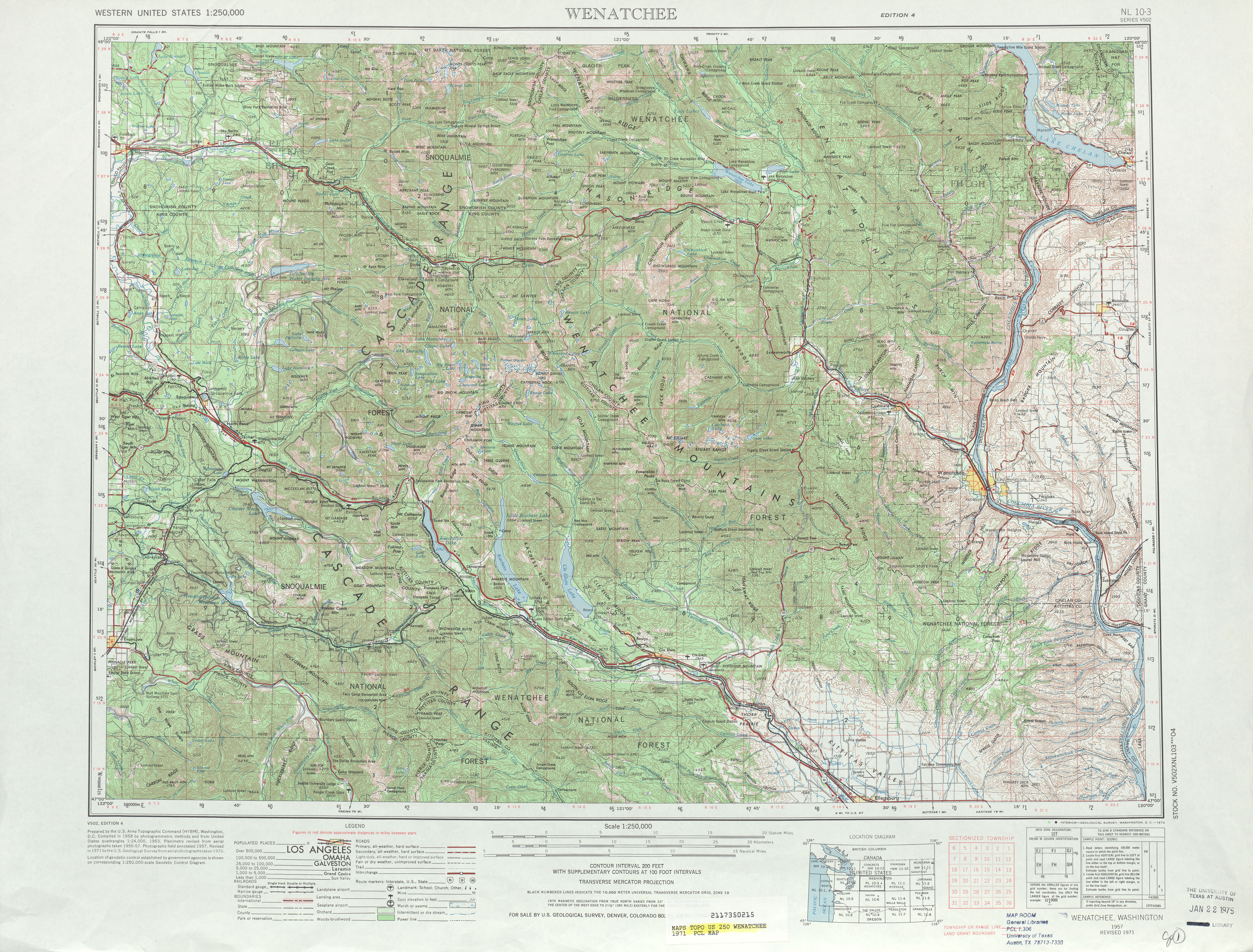
- ^ University of Texas at Austin (1971). Wenatchee, 1971 (Map). 1:250,000. http://www.lib.utexas.edu/maps/topo/250k/txu-pclmaps-topo-us-wenatchee-1971.jpg. Retrieved 9 July 2009.
- ^ Washington State Legislature (1975). "RCW 47.17.917: State route No. 970". http://apps.leg.wa.gov/RCW/default.aspx?cite=47.17.917. Retrieved 9 July 2009.
- ^ Washington State Legislature (1984). "RCW 47.17.824: State route No. 823". http://apps.leg.wa.gov/RCW/default.aspx?cite=47.17.824. Retrieved 8 July 2009.
- ^ a b Washington State Legislature (1970; repealed 1987). "RCW 47.17.290: State route No. 151". http://apps.leg.wa.gov/RCW/default.aspx?cite=47.17.290. Retrieved 8 July 2009.
- ^ a b Washington State Legislature (1987). "RCW 47.17.157: State route No. 97–alternate". http://apps.leg.wa.gov/RCW/default.aspx?cite=47.17.157. Retrieved 8 July 2009.
- ^ Washington State Department of Transportation (2009). "Agency Projects: Completed Projects for US 97". http://www.wsdot.wa.gov/Projects/completed?s=county,funding,location,route-us97#listing. Retrieved 9 July 2009.
- ^ a b Washington State Department of Transportation (2006). "US 97 – NCR Roadside Safety – Complete August 2006". http://www.wsdot.wa.gov/projects/us97/ncrroadsidesafety/. Retrieved 9 July 2009.[dead link]
- ^ Washington State Department of Transportation (2005). US 97 – Kittitas, Chelan, and Okanogan Counties Roadside Safety Improvement (Map). Cartography by Tele Atlas. http://www.wsdot.wa.gov/Projects/US97/NCRRoadsideSafety/Map.htm. Retrieved 9 July 2009.
- ^ American Association of State Highway and Transportation Officials (5 October 2006). "An Application from the State Highway or Transportation Department of Washington for US 197". http://cms.transportation.org/sites/route/docs/ElectronicApplicationFormUS197.pdf. Retrieved 9 July 2009.
- ^ Washington State Department of Transportation (2007). "US 97 – Oroville Vincity – Paving – Complete September 2007". http://www.wsdot.wa.gov/projects/us97/orovillevicinitypaving/. Retrieved 9 July 2009.
- ^ Washington State Department of Transportation (2005). US 97 – Oroville Vincity Paving (Map). Cartography by Tele Atlas. http://www.wsdot.wa.gov/Projects/US97/OrovilleVicinityPaving/Map.htm. Retrieved 9 July 2009.
- ^ Washington State Department of Transportation (2008). "US 97 – Klickitat County – Roadside Safety – Complete July 2008". http://www.wsdot.wa.gov/projects/us97/klickitatsafety/. Retrieved 9 July 2009.
- ^ Washington State Department of Transportation (2008). US 97 Klickitat County – Roadside Safety (Map). http://www.wsdot.wa.gov/Projects/US97/KlickitatSafety/Map.htm. Retrieved 9 July 2009.
- ^ Washington State Department of Transportation (2008). "US 97 – Brewster – Pedestrian Illumination – Complete December 2008". http://www.wsdot.wa.gov/projects/us97/brewsterpedestrianillumination/. Retrieved 9 July 2009.
- ^ Washington State Department of Transportation (2008). US 97 Brewster Pedestrian Illumination (Map). http://www.wsdot.wa.gov/Projects/US97/BrewsterPedestrianIllumination/Map.htm. Retrieved 9 July 2009.
- ^ Schweizer, Cheryl (11 September 2008). "Sidewalks next step in Highway 97 construction". Quad City Herald (Brewster, Washington). http://www.qcherald.com/main.asp?Search=1&ArticleID=596&SectionID=5&SubSectionID=5&S=1. Retrieved 9 July 2009.
- ^ a b Washington State Department of Transportation (2009). "US 97 – Biggs Rapids – Sam Hill Bridge Deck Replacement – Complete March 2009". http://www.wsdot.wa.gov/projects/us97/biggsbridge/. Retrieved 14 July 2009.
- ^ Washington State Department of Transportation (2009). US 97 – Biggs Rapids–Sam Hill Bridge Deck Replacement – Project Area (Map). http://www.wsdot.wa.gov/Projects/us97/BiggsBridge/map.htm. Retrieved 14 July 2009.
- ^ Tams, Chris; Bateman, Alissa (18 July 2007). "WSDOT Postpones Biggs Bridge Closure until Early '08". Goldendale, Washington: Washington State Department of Transportation. http://www.wsdot.wa.gov/News/2007/07/18_US97BiggsClosure.htm. Retrieved 14 July 2009.[dead link]
- ^ Tams, Chris; Bateman, Alissa (8 November 2007). "US 97, Biggs Bridge Project Begins in December, Complete Closure Begins January 2". Goldendale, Washington: Washington State Department of Transportation. http://www.wsdot.wa.gov/News/2007/11/08_US97Biggs.htm. Retrieved 14 July 2009.[dead link]
- ^ "Worker seriously injured when excavator plunges off Biggs Rapids Bridge into the Columbia". The Oregonian (OregonLive.com). 15 January 2008. http://blog.oregonlive.com/breakingnews/2008/01/worker_seriously_injured_when.html. Retrieved 14 July 2009.
- ^ Ross, Sylvia; Redfield, Joye; Mowat Construction; Fisher, Elaine (16 January 2008). "Clean Up Efforts, Investigation Continues after Biggs Bridge Work Zone Accident". Goldendale, Washington: Washington State Department of Transportation. http://www.wsdot.wa.gov/News/2008/01/16_BiggsDay.htm. Retrieved 14 July 2009.
- ^ Tams, Chris; Ross, Sylvia (23 January 2008). "Construction on Biggs Bridge Resumes January 23". Goldendale, Washington: Washington State Department of Transportation. http://www.wsdot.wa.gov/News/2008/01/23_ConstructionResumesonBridge.htm. Retrieved 14 July 2009.
- ^ Morey, Mike (3 March 2008). "Worker dies in fall from US Highway 97 bridge". Yakima Herald-Republic (Yakima, Washington). http://www.yakimaherald.com/stories/2008/03/03/worker-dies-in-fall-from-us-highway-97-bridge. Retrieved 14 July 2009.
- ^ Tams, Chris; Wright, Jermey (2 April 2008). "Important Mileston Reached on US 97 – Biggs Bridge Project". Goldendale, Washington: Washington State Department of Transportation. http://www.wsdot.wa.gov/News/2008/04/02_MilestoneReachedonUS97.htm. Retrieved 14 July 2009.
- ^ Tams, Chris; Wright, Jermey (19 May 2008). "Sam Hill – Biggs Rapids Bridge to Re-Open Today, May 19, at 6 p.m.". Goldendale, Washington: Washington State Department of Transportation. http://www.wsdot.wa.gov/News/2008/05/19_BiggsReopening.htm. Retrieved 14 July 2009.
- ^ Tams, Chris; Russell, Abbi (13 August 2008). "Night time lane closures begin next week for US 97, Biggs Bridge project, complete closure begins September 3". Goldendale, Washington: Washington State Department of Transportation. http://www.wsdot.wa.gov/News/2008/08/13_BiggsNightSingleLaneClosuresBegin.htm. Retrieved 14 July 2009.
- ^ Tams, Chris; Ross, Sylvia (25 August 2008). "US 97, Biggs Rapids – Sam Hill Bridge closes September 8 for final stage of construction". Goldendale, Washington: Washington State Department of Transportation. http://www.wsdot.wa.gov/News/2008/08/25_US97BiggsClosedSep8.htm. Retrieved 14 July 2009.
- ^ Tams, Chris; Russell, Abbi (2 September 2008). "WSDOT reminds drivers of US 97, Biggs Rapids – Sam Hill Bridge closure September 8". Goldendale, Washington: Washington State Department of Transportation. http://www.wsdot.wa.gov/News/2008/09/02_BiggsClosureReminder.htm. Retrieved 14 July 2009.
- ^ Tams, Chris; Russell, Abbi (19 December 2008). "WSDOT reopens the Biggs Rapids–Sam Hill Bridge in time for the holidays". Goldendale, Washington: Washington State Department of Transportation. http://www.wsdot.wa.gov/news/2008/12/19_BiggsBridgeReopens. Retrieved 14 July 2009.
- ^ Tams, Chris; Russell, Abbi (24 December 2008). "WSDOT opens Biggs Rapids–Sam Hill Bridge at 4 p.m. today". Goldendale, Washington: Washington State Department of Transportation. http://www.wsdot.wa.gov/News/2008/12/24_BiggsReopensDayOf.htm. Retrieved 14 July 2009.
- ^ Tams, Chris; Russell, Abbi (23 March 2009). "Biggs Rapids–Sam Hill deck replacement project wraps up early". Goldendale, Washington: Washington State Department of Transportation. http://www.wsdot.wa.gov/news/2009/03/23_BiggsWrapsUpEarly. Retrieved 14 July 2009.
- ^ Washington State Department of Transportation (2009). "Agency Projects: Highway, Ferry and Rail Construction and Improvement Projects for US 97". http://www.wsdot.wa.gov/Projects/?s=county,funding,location,route-us97#listing. Retrieved 14 July 2009.
- ^ Adamson, Jeff; Andreini, Mike (10 April 2009). "WSDOT awards US 97 Blewett Pass emergenccy flood repair contract". Wenatchee, Washington: Washington State Department of Transportation. http://www.wsdot.wa.gov/News/2009/04/10US97BlewettEmergencyRepairs.htm. Retrieved 14 July 2009.
- ^ Washington State Department of Transportation (2009). "US 97 – Blewett Pass Emergency Flood Repair Stages 2 – 3". http://www.wsdot.wa.gov/projects/us97/blewettpassemrepst2/. Retrieved 14 July 2009.
- ^ Washington State Department of Transportation (2009). Blewett Pass Emergency Flood Repair Stage 2 (Map). http://www.wsdot.wa.gov/Projects/US97/BlewettPassEmRepSt2/map.htm. Retrieved 14 July 2009.
- ^ Washington State Department of Transportation (2009). "US 97 – South of Tonasket – Bridge Deck Repair". http://www.wsdot.wa.gov/projects/us97/stonasketbridgedeck/. Retrieved 14 July 2009.
- ^ Washington State Department of Transportation (2009). US 97 – South of Tonasket – Bridge Deck Repair (Map). Cartography by Tele Atlas. http://www.wsdot.wa.gov/Projects/US97/STonasketBridgeDeck/Project+Map.htm. Retrieved 14 July 2009.
- ^ Washington State Department of Transportation (2009). "US 97 – SR 155 Intersection and Border Vincity Improvements". http://www.wsdot.wa.gov/projects/us97/intersectionsafety/. Retrieved 14 July 2009.
- ^ Washington State Department of Transportation (2009). US 97 Intersection Safety Improvements (Map). Cartography by Tele Atlas. http://www.wsdot.wa.gov/projects/us97/intersectionsafety/map.htm. Retrieved 14 July 2009.
- ^ Washington State Department of Transportation (2009). "US 97 – Eight miles south of US 2 Intersection – Unstable Slope". http://www.wsdot.wa.gov/projects/us97/slope8milessofus2/. Retrieved 14 July 2009.
- ^ Washington State Department of Transportation (2007). US 97 8 Miles South of US 2 Intersection – Unstable Slope (Map). Cartography by Tele Atlas. http://www.wsdot.wa.gov/Projects/US97/Slope8MilesSofUS2/Map.htm. Retrieved 14 July 2009.
- ^ Washington State Department of Transportation (2009). "US 97 – North of Blewett Pass – Unstable Slope". http://www.wsdot.wa.gov/projects/us97/slopenofblewett/. Retrieved 14 July 2009.
- ^ Washington State Department of Transportation (2007). US 97 North of Blewett Pass – Unstable Slope (Map). Cartography by Tele Atlas. http://www.wsdot.wa.gov/Projects/US97/SlopeNofBlewett/map.htm. Retrieved 14 July 2009.
- ^ Washington State Department of Transportation (2009). "US 97 – Blewett Pass – Passing Lane". http://www.wsdot.wa.gov/projects/us97/blewettpasspassinglane/. Retrieved 14 July 2009.
- ^ Washington State Department of Transportation (2009). US 97 Blewett Passing Lane Map (Map). http://www.wsdot.wa.gov/Projects/US97/BlewettPassPassingLane/MAP.htm. Retrieved 14 July 2009.
- ^ Washington State Department of Transportation (2009). "US 97 – Satus Creek Bridge – Bridge Replacement". http://www.wsdot.wa.gov/projects/us97/satuscreekbridge/. Retrieved 14 July 2009.
- ^ Washington State Department of Transportation (2009). US 97 – Satus Creek Bridge – Bridge Replacement (Map). http://www.wsdot.wa.gov/Projects/US97/SatusCreekBridge/map.htm. Retrieved 14 July 2009.
- ^ Washington State Department of Transportation (2009). "US 97 – Orondo Northward Paving". http://www.wsdot.wa.gov/projects/us97/orondonorthpaving/. Retrieved 14 July 2009.
- ^ Washington State Department of Transportation (2009). US 97 – Orondo Northward Paving (Map). http://www.wsdot.wa.gov/Projects/US97/OrondoNorthPaving/Map.htm. Retrieved 14 July 2009.
- ^ Google, Inc. Google Maps – U.S. Route 97 Alternate (Map). Cartography by Google, Inc. http://maps.google.com/maps?f=d&source=s_d&saddr=US-2%2FUS-97&daddr=47.7592622,-120.2003056+to:US-97&hl=en&geocode=FQxe1AIdQP3T-A%3BFZ6_2AIdj-PV-CnhOPnC6qKbVDERgwRz8kkkEw%3BFTt62gIdjija-A&mra=mi&mrsp=1,0&sz=16&sll=47.873828,-119.9212&sspn=0.010449,0.019248&ie=UTF8&ll=47.677409,-120.168457&spn=0.671291,1.231842&z=10&via=1. Retrieved 8 July 2009.
- ^ Google, Inc. Google Maps – U.S. Route 97 Spur (Map). Cartography by Google, Inc. http://maps.google.com/maps?f=d&source=s_d&saddr=US-2&daddr=47.626956,-120.222804&geocode=FaC91gIdknfV-A%3B&hl=en&mra=dme&mrcr=0&mrsp=1&sz=18&sll=47.626518,-120.223802&sspn=0.002625,0.004812&ie=UTF8&ll=47.627006,-120.225534&spn=0.00525,0.009624&z=17. Retrieved 8 July 2009.
External links
State highways in Washington related to US 97  Former or proposed: SR 131 - SR 151
 U.S. Routes in Washington U.S. Route 97
Previous state:
OregonWashington Next state:
TerminusCategories:- U.S. Route 97
- Transportation in Klickitat County, Washington
- Transportation in Yakima County, Washington
- Transportation in Kittitas County, Washington
- Transportation in Chelan County, Washington
- Transportation in Douglas County, Washington
- Transportation in Okanogan County, Washington
- U.S. Highways in Washington (state)
- Scenic highways in Washington (state)


Wikimedia Foundation. 2010.