Washington State Route 173
- Washington State Route 173
Infobox WA State Route
type=State
route=173
sec=360
parent_type=WA
parent=17
length_mi=11.86
length_ref=[cite web|author=Washington State Department of Transportation|url=http://www.wsdot.wa.gov/mapsdata/tdo/PDF_and_ZIP_Files/HwyLog2006.pdf|title=State Highway Log, 2006|accessdate=2007-04-22] ]
length_round=2
formed=1964
dir2=East
dir1=West
to=
from=
previous_type=WA
previous_route=172
next_type=WA
next_route=174
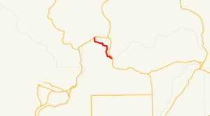
State Route 173 is a state highway in the U.S. state of Washington, running from SR 17 in Bridgeport to US 97 in Brewster.
History
There are two bridges along the route of SR 173. They each cross the same river, the Columbia River. The bridge at Brewster was built in the 1920s, but the bridge at Bridgeport was built at about the same time as the Chief Joseph Dam, around 1950, which was built nearby. The Bridgeport bridge caught fire sometime in the 1960s and was replaced with the current bridge.
Before 1964, SR 173 was the Brewster-Bridgeport branch of PSH 10. [ [http://www.angelfire.com/wa2/hwysofwastate/sr173.html Highways of Washington State] Retrieved April 2, 2008]
Major intersections
*
*
References
Wikimedia Foundation.
2010.
Look at other dictionaries:
Washington State Route 410 — Tracé de la route. La Washington State Route 410 (SR410), dont un tronçon porte le nom de Chinook Scenic Byway, est une route d État américaine longue de 173 km[1] située dans l État de Washington au nord ouest … Wikipédia en Français
Washington State Route 174 — Infobox WA State Route type=State route=174 sec=365 parent type=WA parent=17 length mi=40.66 length ref=cite web|author=Washington State Department of Transportation|url=http://www.wsdot.wa.gov/mapsdata/tdo/PDF and ZIP… … Wikipedia
Washington State Route 172 — Infobox WA State Route type=State route=172 sec=355 parent type=WA parent=17 length mi=35.01 length ref=cite web|author=Washington State Department of Transportation|url=http://www.wsdot.wa.gov/mapsdata/tdo/PDF and ZIP… … Wikipedia
New York State Route 173 — NYS Route 173 Map of the Syracuse area with NY 173 highlighted in red Route information … Wikipedia
State Route 74 (New York–Vermont) — Infobox road highway name=NYS/VT Route 74 marker map notes=NY 74 and VT 74 highlighted in red route=74 maint=NYSDOT and VTrans length mi=34.70 length notes=New York: 20.44 mi Vermont: 13.26 mi length round=2 length ref= established=New York:… … Wikipedia
State Route 74 (New York — New York State Route 74 redirects here. For previous alignments of NY 74, see New York State Route 74 (disambiguation). NYS/VT Route 74 … Wikipedia
New York State Route 5 — NY 5 redirects here. NY 5 may also refer to New York s 5th congressional district. NYS Route 5 Map of New York with NY 5 highlighted in red … Wikipedia
New York State Route 20SY — NYS Route 20SY Map of the Syracuse area with NY 20SY highlighted in red Route information … Wikipedia
173 (number) — 173 is the natural number following 172 and preceding 174. List of numbers Integers << 170 171 172 173 174 175 176 177 178 179 >> … Wikipedia
New York State Route 92 — NYS Route 92 Map of the Syracuse area with NY 92 highlighted in red Route information … Wikipedia
