- State Route 74 (New York
-
"New York State Route 74" redirects here. For previous alignments of NY 74, see New York State Route 74 (disambiguation).
NYS/VT Route 74

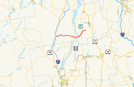
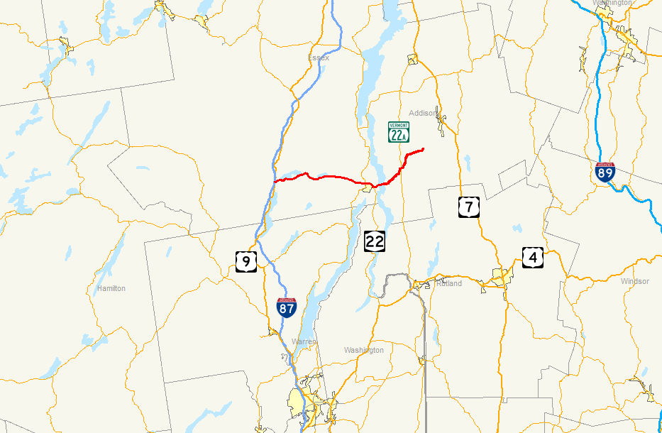
Map of northeastern New York and western Vermont with NY 74 and VT 74 highlighted in redRoute information Maintained by NYSDOT (NY 74) and VTrans (VT 74) Length: 34.70 mi (55.84 km)
NY 74: 20.44 mi;[1] VT 74: 13.263 mi[2]History: NY 74 designated NY 73 in 1930;[3] renumbered to NY 74 ca. 1973[4][5]
VT 74 assigned mid-1950s[6][7]Major junctions West end:  I-87 in Schroon, NY
 NY 9N / NY 22 in Ticonderoga, NY
 VT 22A in Shoreham, VT
East end:  VT 30 in Cornwall, VT
Location Counties: Essex (NY), Addison (VT) Highway system Numbered highways in New York
Interstate • U.S. • N.Y. (former) • Reference • County
State highways in Vermont←  NY 73
NY 73New York NY 75  →
→←  VT 73
VT 73Vermont VT 78  →
→New York State Route 74 (NY 74) and Vermont Route 74 (VT 74) are adjoining state highways in the northeastern United States, connected by one of the last remaining cable ferries in North America. Together they extend for 35 miles (56 km) through Essex County, New York, and Addison County, Vermont. NY 74 begins at exit 28 off Interstate 87 (I-87) in the hamlet of Severance in the Adirondack Mountains region of the northern part of New York State. It extends 20.44 miles (32.89 km) to the western shore of Lake Champlain in Ticonderoga. There, the seasonal Fort Ticonderoga – Larrabees Point Ferry carries cars across the state border into Vermont, where VT 74 starts at the lake's eastern shore and terminates 13.26 miles (21.34 km) later at a junction with VT 30 in the town of Cornwall.
NY 74 is a descendant of the historic Ticonderoga and Schroon Turnpike, which was a privately owned highway chartered in 1832, and segments of NY 74 follow the alignment of the original 19th century turnpike. The connecting ferry route predates both NY 74 and VT 74 and began operation in 1759 on an informal basis. The ferry operation formalized at the close of the 18th century and upgraded to a cable system in 1946.
Due to extensive changes in designations in both states during the 20th century, the entire length of the present highway consists of renamed segments from other highways. The New York portion of the cross-state Route 74 west of Ticonderoga was designated as part of NY 73 in the 1930 renumbering of state highways in New York, while the Vermont section carried several different designations from the 1920s to the late 1930s, when it became solely part of Vermont Route F-9. NY 73 was extended east to Lake Champlain in the 1950s—replacing New York State Route 347—and VT F-9 was split into VT 73 and VT 74 shortly afterward. The Schroon–Ticonderoga highway was redesignated as NY 74 ca. 1973 after NY 73 was cut back to its current eastern terminus in Elizabethtown.
Contents
Route description
NY 74
NY 74 originates at exit 28 of the Adirondack Northway (I-87) in the town of Schroon. The starting interchange is located near local landmark Severance Hill, which reaches an altitude of 1,600 feet (490 m). Route 74 intersects with the north–south U.S. Route 9 (US 9) shortly after the northbound ramps of the Adirondack Northway. It then meets Stowell Road just before crossing the Schroon River. The highway meets a few local road intersections just south of Goosebury Hill before encountering Paradox Lake. NY 74 runs mostly parallel to the lake and intersects with a local campground entrance road as it continues eastward from Schroon.[8]
 The western terminus of NY 74 at I-87. The end sign, however, is located at US 9.
Cotters Pond is a small landmark located beyond a few mountains and hills on the southern side of Route 74 near the end of Paradox Lake. Cotters Pond, by state law, is a water body that cannot be used for baitfishing. This was designated by the New York State Department of Environmental Conservation.[9] Shortly afterward, NY 74 passes Bumbo Pond and enters the hamlet of Paradox. After leaving Paradox, Route 74 turns to the southeast along the base of Skiff Mountain. The highway then approaches a creek that flows into Eagle Lake. Route 74 crosses over Eagle Lake and runs along the base of Eagle Cliff and the shores of the lake. After leaving Eagle Lake, the highway intersects with County Route 2 (CR 2), the first numbered highway that NY 74 encounters after US 9.[8]
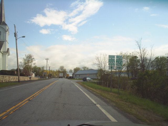
This stretch of NY 74 skirts the base of Keeney Mountain, which peaks at 1,400 feet (430 m). Route 74 then intersects with CR 56, which parallels the main route to the south. Route 56 merges back with Route 74, which leaves the mountainous region for the hamlet of Ticonderoga. NY 74 intersects with NY 9N and NY 22 in the hamlet; the latter of the two highways becomes concurrent with NY 74. Routes 74 and 22 continue to the east, heading around the outskirts of Ticonderoga. NY 74 intersects with CR 49 before Route 74 turns to the southeast. Route 74 and Route 22 head southward toward the center of Ticonderoga. At the intersection with Montcalm Street, Route 74 turns eastward off Route 22, which heads southward for Washington County.[8]
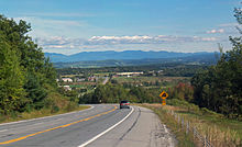 View towards Vermont as Route 74 descends to Ticonderoga
Route 74 crosses local roads as it continues eastward toward Lake Champlain. The highway passes the entrance to Fort Ticonderoga and the Ticonderoga Amtrak station. The New York portion of Route 74 terminates at a ferry landing by Lake Champlain at the state border.[8]
Fort Ticonderoga – Larrabees Point Ferry
The Fort Ticonderoga – Larrabees Point Ferry is the oldest and southernmost ferry on Lake Champlain.[10] Its cable system consists of two 1.1-inch (2.8 cm) steel cables in parallel alignment.[11] The current ferry barge, in operation since 1959, is powered by a sixteen-ton tugboat built in 1979 that can hold up to 18 cars.[10] The seasonal ferry is half a mile long and operates from May through October.[11][12] The seven-minute passage operates during daylight hours.[10]
VT 74
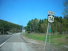
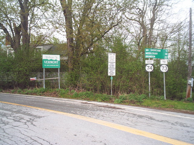
After crossing the state line via the Fort Ticonderoga – Larrabees Point Ferry, Route 74 begins its track into Vermont. The highway heads a short distance to the north, passing a thinly populated area in Shoreham, as intermittent forest yields to fields and farmlands. After 0.49 miles (0.79 km) from the border, Route 74 intersects with Route 73 before encountering Barnum Hill Road. Near the Barnum Hill intersection Route 74 passes developed areas and bends more toward the north. VT 74 then turns to the northeast at Smith Street and enters a patch of forest. Afterward Route 74 climbs a hill and intersects with Harrington Hill Road where it turns northward once again.[13]
 Signs at the southern end of VT 74's concurrency with VT 22A
Fields and forests surround this thinly populated stretch of highway. At the intersection with Blue Harbor Road Route 74 turns to the east and heads toward downtown Shoreham. Within central Shoreham, VT 74 is known as Main Street and has a short concurrency with Route 22A. As VT 74 leaves the densely populated portion of Shoreham, the concurrency ends and Route 74 takes a eastward turn toward Cornwall.[13]
As Route 74 returns to the rural countryside it bends toward the northeast for most of the distance to Cornwall. Through this stretch the highway winds through forests and occasional farmland. VT 74 straightens at an intersection with Bates Road. A connector road called North Palmer Road merges with Route 74 shortly afterward. VT 74 winds again for a stretch and straightens a second time near the intersection with Elmendorf Road as it continues toward Cornwall, intersecting with several township highways and approaching increasingly residential areas. At Clark Road in Cornwall, Route 74 turns to the northeast once again, passing through more forests before terminating at VT 30 in Cornwall.[13]
Early history
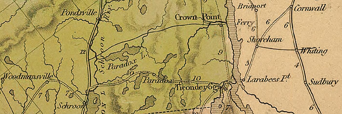

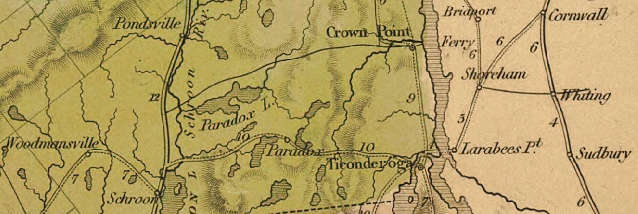
The Ticonderoga and Schroon Turnpike and surrounding region, detail from an 1839 map of New York State Schroon and its early highways
Settlers of European descent began to populate the region near modern Schroon around 1797. The area's first municipality was the town of Crown Point, which originally included considerable portions of thinly populated land that later developed into separate townships. The first of these divisions occurred on March 20, 1804 with the establishment of the town of Schroon. Minerva split from Crown Point in March 1817, before another municipal reorganization in 1840 implemented further reductions to the land area of Crown Point. During this period two thoroughfares served the area that correspond to parts of modern NY 74 and US 9. One of these old state roads traversed the route covered by the current alignment of NY 74 from Schroon to Ticonderoga.[14]
Ticonderoga and Schroon Turnpike
The entire length of NY 74 from Ticonderoga to Schroon covers the same route as the 19th century Ticonderoga and Schroon Turnpike. The turnpike, chartered in April 1832, was built to a stretch of highway from the two towns.[15] Two toll gates were erected specifically for use on the highway, and the charter allowed for additional toll gates at a spacing of approximately one for every ten miles of completed highway. The turnpike management raised funds by selling 600 shares valued at $25 each. $20,000 (1832 USD) was also set aside for properties along the highway.[16]
Designation history
Designations from 1913 to the 1930s
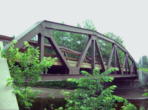
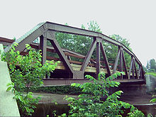 A truss bridge on NY 74 in Essex County
In 1913, the New York State Legislature designated most of modern NY 74 as Route 22-b, an unsigned legislative route. It ran for 17.06 miles (27.46 km) from Route 22 (now US 9) in Schroon to the western edge of the then-village of Ticonderoga.[17][18] On March 1, 1921, Route 22-b became part of Route 48, a new route created as part of a partial renumbering of New York's legislative route system.[19] In 1924, when state highways were first publicly signed with route numbers, the highway from Schroon to Ticonderoga remained unnumbered.[20] During the 1930 renumbering of state highways in New York, the segment of modern NY 74 between US 9 in Schroon and NY 22 in Ticonderoga was designated as part of NY 73,[3] a route extending from NY 28N in Tahawus to Ticonderoga. NY 73 followed the Blue Ridge Road from Tahawus to North Hudson and had an overlap with US 9 from North Hudson to Schroon.[21]
The portion of NY 73 between Tahawus and North Hudson was removed from the state highway system ca. 1936. As a result, NY 73 was truncated to a new western terminus at US 9 in Schroon, eliminating the concurrency with US 9.[22][23] The Blue Ridge Road is now designated as CR 84 from NY 28N in Tawahus to the Adirondack Northway in North Hudson,[24] and as NY 910K, a short unsigned reference route, from the Northway to US 9.[25]
On the Vermont side, the road connecting Larrabees Point to the main north–south highways in the area was designated as VT F-9 by 1926. Route F-9 began at the ferry landing at Larrabees Point and continued northeast to Shoreham Center, where it briefly overlapped with then-VT 30A (modern VT 22A). Past VT 30A, Route F-9 continued east along what are now town highways through Whiting to Leicester, where it ended at a junction with US 7. At the time, modern VT 74 between Shoreham and Cornwall centers was known as VT F-9A while what is now VT 73 from Larrabees Point to Brown Lane north of the town center of Orwell was part of VT F-10A.[26]
Changes from 1933 onward
By 1933, the highway linking NY 22 in Ticonderoga to the ferry for Larrabees Point became part of NY 8.[27] Ca. 1934, NY 8 was realigned to follow NY 22 north from Ticonderoga to Crown Point, where it left NY 22 to follow NY 347 (modern NY 185) to the Champlain Bridge. The NY 347 designation was reassigned to NY 8's former routing between NY 22 and the ferry landing east of Ticonderoga.[27][28]
 VT 74 departing from the Larabees Point ferry landing
VT F-9, meanwhile, was extended southward to Orwell over VT F-10A by 1938. Like VT F-10A, it initially bypassed Orwell to the north on Brown Lane;[29] however, it was realigned in the late 1930s to follow modern VT 73 into Orwell. Around the same time, VT F-9 was realigned east of Shoreham to follow VT F-9A northeast to Cornwall. The VT F-9A designation was eliminated while the former routing of Route F-9 between Shoreham and Leicester became unnumbered.[29][30] In the early 1950s, New York extended NY 73 east to the ferry landing by way of NY 347 and Wicker and Montcalm Streets.[6][31] Vermont renumbered the Larrabees Point – Orwell section of VT F-9 to VT 73 in the mid-1950s in order to match the New York route number. At the same time, the Larrabees Point – Cornwall section of VT F-9 was renumbered by Vermont to VT 74.[6][7]
Ca. 1973, NY 73 was truncated to its current eastern terminus in Underwood, eliminating a lengthy overlap with US 9, while its former routing from Schroon to Lake Champlain was renumbered to NY 74, matching the other Vermont route number that ends in Larrabees Point. The already existing Route 74 in Chautauqua County (in the Jamestown area) was renumbered to NY 474 as a result.[4][5] The opening of the Adirondack Northway in 1967 also resulted in a slight shift of the western terminus of NY 74 from US 9 to I-87.[32] By 1981, NY 74 was rerouted to follow its current alignment around the northeastern edge of Ticonderoga, on a concurrency with NY 22.[33] The highway has remained the same since that date.[34]
The New York State Department of Transportation has announced a project to repave Route 74 from Chilson to Paradox. The project is in preliminary development, with construction is expected to begin in early 2013 and reach completion about a year later. Funding will come from state sources and run an estimated cost of $8.6 million.[35]
Ferry history
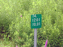 A reference marker for NY 74 near the route's eastern terminus
According to its website, the ferry operated informally from 1759 and in an organized way from 1799.[10] The earliest ferries are believed to have been rowboats or canoes; "a double-ended sailing scow was in service by 1800. This vessel was about 30 feet (9.1 m) long, with a mainsail that would swing completely around the mast to provide a simple means of reversing course."[11]
Ferry size continued to increase with traffic until the system upgraded to a cable guidance system in 1946.[11] John S. Larrabee of Vermont established the first regular ferry at the location in the late 18th century.[36] The Vermont State Legislature approved a franchise for a ferry from Larrabees Point to Ticonderoga in 1907, to the Shoreham and Ticonderoga Ferry Company.[37] The New York State Legislature granted the ferry a franchise in 1918.[38]
Major intersections
County Location Mile[1][2] Destinations Notes Essex Schroon 0.00 I-87Exit 28 (I-87) 0.17  US 9
US 9Ticonderoga 17.46 NY 9N / NY 22 northWestern terminus of NY 22 / NY 74 overlap 19.06 NY 22 southEastern terminus of NY 22 / NY 74 overlap 20.44  VT 74
VT 74Seasonal ferry to Vermont New York – Vermont state line; ferry leads to VT 74 eastbound and NY 74 westbound Addison Shoreham 0.000  NY 74
NY 74Village of Larabees Point; seasonal ferry to New York 0.493 VT 73Western terminus of VT 73 5.241 VT 22A southSouthern terminus of VT 22A / VT 74 overlap 5.670 VT 22A northNorthern terminus of VT 22A / VT 74 overlap Cornwall 13.263 VT 301.000 mi = 1.609 km; 1.000 km = 0.621 mi References
- ^ a b "2008 Traffic Data Report for New York State" (PDF). New York State Department of Transportation. June 16, 2009. p. 210. https://www.nysdot.gov/divisions/engineering/technical-services/hds-respository/NYSDOT_Traffic_Data_Report_2008.pdf. Retrieved October 13, 2009.
- ^ a b "2008 (Route Log) AADTs – State Highways" (PDF). Vermont Agency of Transportation. May 2009. pp. 39, 46. http://www.aot.state.vt.us/Planning/Documents/TrafResearch/Publications/2008RouteLogAADTsFinal.pdf. Retrieved November 7, 2010.
- ^ a b Dickinson, Leon A. (January 12, 1930). "New Signs for State Highways". The New York Times: p. 136.
- ^ a b Gulf Oil Company (1972). New York and New Jersey Tourgide Map (Map). Cartography by Rand McNally and Company (1972 ed.).
- ^ a b Shell Oil Company (1973). New York (Map). Cartography by H.M. Gousha Company (1973 ed.).
- ^ a b c Esso (1954). New York with Special Maps of Putnam–Rockland–Westchester Counties and Finger Lakes Region (Map). Cartography by General Drafting (1955–56 ed.).
- ^ a b Esso (1956). New York with Special Maps of Putnam–Rockland–Westchester Counties and Finger Lakes Region (Map). Cartography by General Drafting (1957 ed.).
- ^ a b c d Google, Inc. Google Maps – overview map of NY 74 (Map). Cartography by Google, Inc. http://maps.google.com/maps?hl=en&rlz=1T4ADBF_enUS232US232&q=from:+NYS+Route+74/RT-74+%4043.871460,+-73.755100+to:+RT-74+%4043.854022,+-73.385637&um=1&ie=UTF-8&sa=N&tab=wl. Retrieved January 30, 2008.
- ^ "Special Fishing Regulations for Essex County". New York State Department of Environmental Conservation. 2009. http://www.dec.ny.gov/outdoor/31443.html. Retrieved January 2, 2009.
- ^ a b c d Peden, James A. (2008). "Ticonderoga Ferry". Middlebury Networks. http://www.middlebury.net/tiferry/. Retrieved August 27, 2008.
- ^ a b c d Ticonderoga Area Chamber of Commerce (2008). "Fort Ticonderoga Ferry". Ticonderoga Area Chamber of Commerce. http://www.ticonderogany.com/members/fortticonderogaferry.html. Retrieved August 27, 2008.
- ^ Google Maps. Fort Ticonderoga - Larrabees Point Fry @43.854016, -73.385363 (Map). http://maps.google.com/maps?sourceid=navclient&ie=UTF-8&rlz=1T4ADBF_enUS232US232&q=from%3A%20Fort%20Ticonderoga-Larrabees%20Point%20Fry%20%4043.854016%2C%20-73.385363%20to%3A%20Fort%20Ticonderoga-Larrabees%20Pt%20Fry%20%4043.855254%2C%20-73.376423&um=1&sa=N&tab=wl. Retrieved August 27, 2008.
- ^ a b c Google, Inc. Google Maps – overview map of VT 74 (Map). Cartography by Google, Inc. http://maps.google.com/maps?sourceid=navclient&ie=UTF-8&rlz=1T4ADBF_enUS232US232&q=from%3A%20Fort%20Ticonderoga-Larrabees%20Pt%20Fry%20%4043.854510%2C%20-73.381900%20to%3A%20VT-74%20%4043.887550%2C%20-73.322276%20to%3AVT-74%20%4043.960808%2C%20-73.209842&um=1&sa=N&tab=wl. Retrieved August 26, 2008.
- ^ Smith, H.P. (1885). The History of Essex County. D. Mason and Company.
- ^ New York State Senate (1832). Journal of the Senate of the State of New-York, at their Fifty-Fifth session. E. Croswell. p. 312. http://books.google.com/books?id=c-VKAAAAMAAJ&pg=PA312&dq=Ticonderoga+and+Schroon+Turnpike&ei=W7e0SPHvGJWKyQTozNG0Dw. Retrieved August 27, 2008.
- ^ New York (State). Legislative (1832). Laws of the State of New York Passed at the Sessions of the Legislature. Legislative Bill Drafting Commission. pp. 520–521. http://books.google.com/books?id=o1k4AAAAIAAJ&pg=PA520&dq=ticonderoga+and+schroon+turnpike&lr=&ei=CXyxSKjJN43IywThv9CFBw#PPA520,M1v. Retrieved August 24, 2008.
- ^ New York State Legislature (1918). "Tables of Laws and Codes Amended or Repealed". Laws of the State of New York passed at the One Hundred and Forty-First Session of the Legislature. Albany, New York: J. B. Lyon Company. p. 72. http://books.google.com/books?id=ffqwAAAAIAAJ&pg=RA1-PA72. Retrieved July 31, 2009.
- ^ New York State Department of Highways (1920). Report of the State Commissioner of Highways. Albany, New York: J. B. Lyon Company. p. 533. http://books.google.com/books?id=Sj4CAAAAYAAJ&pg=PA533. Retrieved July 31, 2009.
- ^ New York State Legislature (1921). "Tables of Laws and Codes Amended or Repealed". Laws of the State of New York passed at the One Hundred and Forty-Fourth Session of the Legislature. Albany, New York: J. B. Lyon Company. pp. 42, 60, 71–72. http://books.google.com/books?id=6pE4AAAAIAAJ&pg=PA42. Retrieved April 30, 2010.
- ^ "New York's Main Highways Designated by Numbers". The New York Times: p. XX9. December 21, 1924.
- ^ Standard Oil Company of New York (1930). Road Map of New York (Map). Cartography by General Drafting.
- ^ Sun Oil Company (1935). Road Map & Historical Guide — New York (Map). Cartography by Rand McNally and Company.
- ^ Esso (1936). New York State Map (Map). Cartography by General Drafting Inc..
- ^ Google, Inc. Google Maps – overview map of Essex CR 84 (Map). Cartography by Google, Inc. http://maps.google.com/maps?sourceid=navclient&ie=UTF-8&rlz=1T4ADBF_enUS232US232&q=from%3A%20Blue%20Ridge%20Rd%2FCR-84%20%4043.948310%2C%20-74.068730%20to%3A%20Blue%20Ridge%20Rd%2FCR-84%20%4043.952648%2C%20-73.728458&um=1&sa=N&tab=wl. Retrieved August 26, 2008.
- ^ New York State Department of Transportation (January 2009) (PDF). Official Description of Highway Touring Routes, Bicycling Touring Routes, Scenic Byways, & Commemorative/Memorial Designations in New York State. https://www.nysdot.gov/divisions/operating/oom/transportation-systems/repository/2009%20tour-bk.pdf. Retrieved October 14, 2008.
- ^ Bureau of Public Roads; Vermont State Highway Department (1927) (PDF). Report of a Survey of Transportation on the State Highways of Vermont. pp. 68, 83–84. http://www.aot.state.vt.us/planning/documents/mapping/publications/1927Doc_full.pdf. Retrieved April 30, 2010.
- ^ a b Texas Oil Company (1932). Texaco Road Map – New England (Map). Cartography by Rand McNally and Company.
- ^ Texas Oil Company (1934). Road Map of New York (Map). Cartography by Rand McNally and Company.
- ^ a b Thibodeau, William A. (1938). The ALA Green Book (1938–39 ed.). Automobile Legal Association.
- ^ Gulf Oil Company (1940). New York Info-Map (Map). Cartography by Rand McNally and Company.
- ^ Sunoco (1952). New York (Map). Cartography by Rand McNally and Company.
- ^ Metcalfe, Ann Breen (2008). "Presenting the winner of Adirondack Life's profile–writing contest 2007". Adirondack Life. http://www.adirondacklife.com/index.php?Itemid=173&id=96&option=com_content&task=view. Retrieved October 5, 2008.
- ^ State of New York (1981). I Love New York Tourism Map (Map). Cartography by Rand McNally and Company.
- ^ New York State Department of Transportation (1992). Ticonderoga Digital Raster Quadrangle (Map). 1:24,000. http://www.nysgis.state.ny.us/gisdata/quads/drg24/dotpreview/index.cfm?code=j51. Retrieved January 20, 2010.
- ^ "Route 74 from Chilson to Paradox". New York State Department of Transportation. 2008. https://www.nysdot.gov/portal/pls/portal/MEXIS_APP.WEPIDYNPAGEMULTI.show?p_arg_names=p_pin&p_arg_values=111000. Retrieved December 20, 2008.
- ^ Smith, H.P. (1886). History of Addison county, Vermont. D. Mason & Co., Publishers. chapter 32. Archived from the original on March 24, 2008. http://web.archive.org/web/20080324023825/http://www.middlebury.edu/academics/lis/lib/guides_and_tutorials/subject_guides/collection_guide-vermont/internet_resources/history_addison_county/chap32_hac.htm. Retrieved August 27, 2008.
- ^ Mr. Alexander, from the committee on elections (1907). Journal of the House of the State of Vermont. Vermont General Assembly. p. 207. http://books.google.com/books?id=ZaxMAAAAMAAJ&pg=PA207&dq=Larabees+Point+Ferry&lr=&ei=rW20SNCQA4nKjgGbqIQa#PPA208,M1. Retrieved August 26, 2008.
- ^ New York State Legislative Bill Drafting Commission (1918). Laws of the State of New York. State of New York. p. 288. http://books.google.com/books?id=KIM4AAAAIAAJ&pg=RA1-PA288&dq=Larrabees+Point+Ferry&lr=&ei=5Z-0SK-iF4m6zATmpvX1Dg. Retrieved August 27, 2008.
External links

Wikimedia Commons has media related to: - New York Routes – New York State Route 74
- New York State Highway Termini – New York State Route 74
- Photographs of VT 74 termini (state-ends.com)
 Highways in Essex County, New York
Interstate 87 • New York State Route 185 • New York State Route 192 • New York State Route 373 • New York State Route 431 • New York State Route 910K • New York State Route 910M • New York State Route 912T • New York State Route 913Q • New York State Route 915F • New York State Route 915K
Categories:- State highways in New York
- State highways in Vermont
- Transportation in Essex County, New York
- Transportation in Addison County, Vermont


Wikimedia Foundation. 2010.