- State Route 314 (New York
-
NYS/VT Route 314

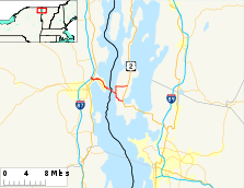
Map of the Grand Isle area with NY 314 and VT 314 highlighted in redRoute information Maintained by NYSDOT and Clinton County (NY 314) and VTrans (VT 314) Length: 10.22 mi (16.45 km)
NY 314: 4.73 mi;[1] VT 314: 5.493 mi[2]History: NY 314 assigned ca. 1962[3][4]
VT 314 assigned early 1960s[4][5]Major junctions West end:  I-87 in Plattsburgh, NY
 US 9 in Plattsburgh, NY
East end:  US 2 in Grand Isle, VT
Location Counties: Clinton (NY), Grand Isle (VT) Highway system Numbered highways in New York
Interstate • U.S. • N.Y. (former) • Reference • County
State highways in Vermont←  NY 313
New York NY 315  →
→←  VT 313
Vermont VT 315  →
→New York State Route 314 (NY 314) and Vermont Route 314 (VT 314) are a pair of like-numbered state highways in New York and Vermont, United States, that are connected by way of the Plattsburgh – Grand Isle Ferry across Lake Champlain. NY 314 extends for 4.73 miles (7.61 km) through the Clinton County town of Plattsburgh from Interstate 87 (I-87) exit 39 to the ferry landing on Cumberland Head. Its Vermont counterpart is a 5.493-mile (8.840 km) loop route off of U.S. Route 2 (US 2) through the Grand Isle County towns of South Hero and Grand Isle that connects to the ferry near its midpoint.
VT 314 was originally designated as Vermont Route F-3 in the 1920s. The roadway on the New York side was unnumbered until ca. 1962, when Cumberland Head Road was designated as NY 314. VT F-3 was redesignated as VT 314 by 1964 to match the designation present at the New York ferry approach. In 2005, a new highway connecting US 9 to the ferry landing by way of the interior of Cumberland Head was completed and opened to traffic as the Commodore Thomas MacDonough Highway. NY 314 was realigned to follow the new highway while ownership and maintenance of its old alignment was transferred to the town of Plattsburgh.
Contents
Route description
NY 314
NY 314 begins at Adirondack Northway (I-87) exit 39 in the town of Plattsburgh. The route heads southeast as a four-lane divided highway known as Moffitt Road to an intersection with US 9 (the Lakes to Locks Passage) just 0.1 miles (0.2 km) from the I-87 interchange.[6] At this point, maintenance of NY 314 shifts from the New York State Department of Transportation to Clinton County, which maintains the highway as the unsigned County Route 57 (CR 57).[1] Past US 9, NY 314 becomes known as Cumberland Head Road as it curves to the east and runs along the southern edge of Cumberland Bay State Park. At the eastern edge of the park, the median ends and NY 314 narrows to become a two-lane undivided highway.[6]
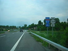 NY 314 at the Adirondack Northway
Just east of the park, Cumberland Head Road forks off of NY 314 to follow the perimeter of Cumberland Head. NY 314, meanwhile, continues east on Commodore Thomas MacDonough Highway, a super two bypassing the perimeter of Cumberland Head and the hamlets of Rocky Point and Champlain Park on the western shore of the peninsula. Roughly 0.25 miles (0.40 km) to the east of the fork, NY 314 intersects Cumberland Head Road again as the latter highway makes its way around Cumberland Head. NY 314 continues on, passing through a dense forest as it bypasses Rocky Point to the northeast. Upon exiting the forest, the highway curves slightly to the southeast and passes through a small area of open fields before heading through another dense forest just east of Champlain Park.[6]
The route continues southward for another 1.5 miles (2.4 km) through the vast forests and fields that make up the interior of Cumberland Head to the southern tip of the peninsula, where it meets Cumberland Head Road one final time. NY 314 continues south for about 400 feet (120 m) before curving to the northeast toward Lake Champlain. The highway and the route both come to an end at a ferry landing for the Plattsburgh – Grand Isle Ferry, which connects to VT 314 on Grand Isle.[6]
VT 314
VT 314 begins at an intersection with US 2 just north of Keeler Bay, a village in the town of South Hero. The route heads northwestward as Ferry Road, passing by a small number of homes situated amongst open fields. At the western edge of Grand Isle, VT 314 intersects West Shore Road, a local highway that runs along the western shoreline of the island. The route turns north onto West Shore Road, following the roadway along Lake Champlain and into the town of Grand Isle. Here, the route's surroundings are mainly the same as it proceeds toward Gordon Landing.[7]
In Gordon Landing, VT 314 connects to a ferry landing for the Plattsburgh – Grand Isle Ferry (which leads to NY 314) by way of an unnamed extension of Bell Hill Road. VT 314 continues northward along West Shore Road to Allen Road, where the route turns to follow Allen Road eastward across the island. While on Allen Road, the route passes through an area of open fields and forests that contains only a couple dozen homes. VT 314 continues eastward to another junction with US 2, where the route comes to an end.[7]
History
Designations
All of modern VT 314 was originally designated as VT F-3[8] in 1924.[citation needed] At Gordon Landing, VT F-3 connected to Cumberland Head in New York by way of a ferry across Lake Champlain. The primary highway leading from the New York ferry landing to US 9 near Plattsburgh, then Cumberland Head Road, was initially unnumbered.[8] VT F-3 was maintained by the towns of South Hero and Grand Isle until June 20, 1957, when the state of Vermont assumed ownership and maintenance of the highway.[9]
Ca. 1961, the portion of the Adirondack Northway (I-87) between exits 36 and 39 was completed and opened to traffic. The portion of Moffitt Road between the new freeway and US 9 was upgraded as part of the Northway's construction.[3][10] By the following year, the upgraded piece of Moffitt Road and the piece of Cumberland Head Road between US 9 and the ferry landing was designated as NY 314.[4] From I-87 to US 9, NY 314 was maintained by the New York State Department of Transportation; the remainder of the route was maintained by Clinton County and co-designated as CR 42.[11] VT F-3 was renumbered to VT 314 between 1962 and 1964 to match the designation now present at the New York ferry approach.[4][5]
Cumberland Head connector
The idea of a building a new highway that would lead directly from US 9 to the ferry landing at the southern tip of Cumberland Head was first proposed in 1964. At that time, a group of Cumberland Head residents stated that the existing narrow and winding perimeter road (NY 314) jeopardized the safety of residents and motorists alike. As time went on, the problem grew worse as the amount of traffic traveling to and from the ferry increased.[12] The proposal finally gained traction in 2002 when New York State Senator Ronald B. Stafford was able to procure most of the $7.3 million required to build the highway. Construction on the new route began in March 2005 following three years of studies and planning.[13]
The Cumberland Head connector began at the east end of the divided highway portion of NY 314 and would pass through the rural interior of the peninsula on its way to the ferry landing. Part of the road would utilize the preexisting Lighthouse Road. It was built as a super two highway with a 45-mile-per-hour (72 km/h) speed limit,[13] 10 miles per hour (16 km/h) higher than that of the perimeter road.[14] The project was initially expected to be completed around November 2006;[15] however, it was completed nearly a year ahead of schedule. On December 1, 2005, the new highway was named the Commodore Thomas MacDonough Highway in honor of Thomas MacDonough, an American naval officer who defeated the British in the Battle of Plattsburgh during the War of 1812. The road opened to traffic about a week later,[12] co-designated as NY 314 (which was realigned to follow the length of the highway) and CR 57.[1] Following the completion of the project, ownership and maintenance of Cumberland Head Road (NY 314's former routing) was to be transferred from Clinton County to the town of Plattsburgh.[13] The transfer was officially approved on September 13, 2006.[16]
The new highway has only two intersections, both with Cumberland Head Road. This was by design as no access roads were built off of the route in an effort to improve safety along the highway.[13] One part of the finished highway that drew controversy was a one-way ramp built between the eastbound MacDonough Highway and the west end of Cumberland Head Road. Some residents criticized the layout, stating that it made it difficult to travel to and from MacDonough Highway and Cumberland Head Road. Ironically, the ramp was added as a result of public input; the initial project designs did not call for a ramp. Instead, all traffic to and from Cumberland Head Road would have had to utilize the junction with MacDonough Highway 0.25 miles (0.40 km) to the east.[14]
Major intersections
NY 314
The entire route is in Plattsburgh, Clinton County.
Mile[1] Destinations Notes 0.00 I-87Exit 39 (I-87) 0.65 US 94.73 Plattsburgh – Grand Isle Ferry To VT 314 1.000 mi = 1.609 km; 1.000 km = 0.621 mi VT 314
The entire route is in Grand Isle County.
Location Mile[2] Destinations Notes South Hero 0.000 US 2Grand Isle 2.243 Plattsburgh – Grand Isle Ferry To NY 314 5.493 US 21.000 mi = 1.609 km; 1.000 km = 0.621 mi
Concurrency terminus • Closed • UnopenedSee also
- State Route 74 (New York – Vermont)
- State Route 346 (New York – Vermont)
References
- ^ a b c d "Clinton County Inventory Listing" (CSV). New York State Department of Transportation. October 1, 2009. https://www.nysdot.gov/divisions/engineering/technical-services/hds-repository2/INV_2009-10-01_Clinton.csv. Retrieved December 16, 2009.
- ^ a b "2008 (Route Log) AADTs – State Highways" (PDF). Vermont Agency of Transportation. May 2009. pp. 66–67. http://www.aot.state.vt.us/Planning/Documents/TrafResearch/Publications/2008RouteLogAADTsFinal.pdf. Retrieved November 7, 2010.
- ^ a b Sunoco (1961). New York and Metropolitan New York (Map). Cartography by H.M. Gousha Company (1961–62 ed.).
- ^ a b c d Esso (1962). New York with Sight-Seeing Guide (Map). Cartography by General Drafting.
- ^ a b Sinclair (1964). New York and Metropolitan New York (Map). Cartography by Rand McNally and Company.
- ^ a b c d Yahoo! Inc. Yahoo! Maps – overview map of NY 314 (Map). Cartography by NAVTEQ. http://maps.yahoo.com/#mvt=h&lat=44.71565&lon=-73.411055&zoom=14&q1=44.733763%2C-73.441957&q2=44.699219%2C-73.380159. Retrieved December 16, 2009.
- ^ a b Google, Inc. Google Maps – overview map of NY 314 (Map). Cartography by Google, Inc. http://maps.google.com/maps?hl=en&rlz=1T4ADBF_enUS232US232&q=from%3A%20US-2%20%26%20VT-314%20%26%20Allen%20Rd%2C%20Grand%20Isle%2C%20Vermont%2005458%2C%20United%20States%20at%20US%202%2C%20to%3A%20Gordon%20Landing%2C%20NY%20to%3A%20Ferry%20Rd%2FVT-314%20at%20US%202&um=1&ie=UTF-8&sa=N&tab=wl. Retrieved October 2, 2008.
- ^ a b Standard Oil Company of New York (1929). New York in Soconyland (Map). Cartography by General Drafting.
- ^ "State Highways History – Route Listing, Exclusive of Interstates with Route Log Notes" (PDF). Vermont Agency of Transportation, Policy and Planning Division – Mapping. October 5, 2007. p. 39. http://www.aot.state.vt.us/Planning/Documents/Mapping/Publications/History_RtLogNotes.pdf. Retrieved December 16, 2009.
- ^ Gulf (1960). New York and New Jersey Tourgide Map (Map). Cartography by Rand McNally and Company.
- ^ New York State Department of Transportation (1979). Plattsburgh Digital Raster Quadrangle (Map). 1:24,000. http://www.nysgis.state.ny.us/gisdata/quads/drg24/dotpreview/index.cfm?code=c51. Retrieved December 16, 2009.
- ^ a b LoTemplio, Joe (December 2, 2005). "Long-awaited Cumberland Head connector road dedicated: Safer Cumberland Head connector road to open in week". Press-Republican (Plattsburgh, New York). http://blog.pressrepublican.com/archive/index.php?option=com_content&view=article&id=31486:long-awaited_cumberland_head_connector_road_dedicated:_safer_cumberland_head_connector_road_to_open_in_week&catid=34:news-articles&Itemid=64. Retrieved December 16, 2009.
- ^ a b c d LoTemplio, Joe (March 16, 2005). "Dream come true: work on connector to start". Press-Republican (Plattsburgh, New York). http://blog.pressrepublican.com/archive/index.php?option=com_content&view=article&id=27915:dream_come_true:_work_on_connector_to_start&catid=34:news-articles&Itemid=64. Retrieved December 16, 2009.
- ^ a b Hutchins, Ryan (May 23, 2006). "Mixed reviews for new connector road on Cumberland Head: Thomas Macdonough Highway generates many mixed feelings". Press-Republican (Plattsburgh, New York). http://blog.pressrepublican.com/archive/index.php?option=com_content&view=article&id=34447:mixed_reviews_for_new_connector_road_on_cumberland_head:_thomas_macdonough_highway_generates_many_mixed_feelings&catid=34:news-articles&Itemid=64. Retrieved December 16, 2009.
- ^ LoTemplio, Joe (July 31, 2005). "Making the connection: Officals [sic] say work on connector road is on schedule". Press-Republican (Plattsburgh, New York). http://blog.pressrepublican.com/archive/index.php?option=com_content&view=article&id=29655:making_the_connection:_officals_say_work_on_connector_road_is_on_schedule&catid=34:news-articles&Itemid=64. Retrieved December 16, 2009.
- ^ "Of Interest: Sept. 17, 2006". Press-Republican (Plattsburgh, New York). September 17, 2006. http://blog.pressrepublican.com/archive/index.php?option=com_content&view=article&id=37801:of_interest:_sept._17,_2006&catid=34:news-articles&Itemid=64. Retrieved December 16, 2009.
External links
Categories:- State highways in New York
- State highways in Vermont
- Transportation in Clinton County, New York
- Transportation in Grand Isle County, Vermont


Wikimedia Foundation. 2010.