- New York State Route 474
-
NYS Route 474
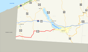
Map of Chautauqua County with NY 474 highlighted in redRoute information Maintained by NYSDOT Length: 24.58 mi[4] (39.56 km) History: Designated NY 74 in 1930;[1] renumbered to NY 474 ca. 1973[2][3] Major junctions West end:  PA 474 at French Creek
East end:  NY 394 near Lakewood
Location Counties: Chautauqua Highway system Numbered highways in New York
Interstate • U.S. • N.Y. (former) • Reference • County←  NY 470
I-478  →
→New York State Route 474 (NY 474) is a state highway located entirely in Chautauqua County, in the westernmost corner of New York in the United States. It begins at the section of the Pennsylvania state line that runs north–south, and runs westward, first parallel to the state line, then further north, to end at NY 394 near Chautauqua Lake.
NY 474 was originally designated as New York State Route 74 in 1930 before being renumbered to NY 474 ca. 1973. The route continues westward into Pennsylvania as Pennsylvania Route 474 (PA 474), which was assigned in the 1980s.
Contents
Route description
NY 474 begins at the Pennsylvania state line in the town of French Creek as a continuation of PA 474, which in turn begins a short distance west of the state line in Wattsburg, Pennsylvania. NY 474 heads east through rural southwest Chautauqua County, briefly paralleling French Creek to the hamlet of Marvin before intersecting and briefly overlapping with NY 426 through the small hamlet of Cutting. NY 474 exits Cutting and continues on an easterly track into the town of Clymer and the hamlet of the same name, where it meets County Route 15 (CR 15), a local road leading from the Pennsylvania state line (where the road continues south to Corry) north to Sherman in the center of the community.
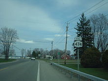 Eastern terminus of NY 474 at NY 394 near Lakewood
East of the hamlet of Clymer, NY 474 turns to the northeast, paralleling an old railroad bed to the community of North Clymer, where NY 474 intersects the southern terminus of NY 76. Outside of North Clymer, the route returns to an east–west alignment prior to entering the town of Harmony and the village of Panama (intersecting CR 33 in the latter) in quick succession. NY 474 continues on, passing through the Harmony hamlet of Blockville and the North Harmony community of Ashville before terminating at NY 394 just west of the Lakewood village limits in the town of Busti.
History
All of what is now NY 474 was originally designated as part of NY 74 as part of the 1930 renumbering of state highways in New York. NY 74 also initially continued east from Lakewood to Jamestown by way of modern NY 394. The remainder of what is now NY 394 from Mayville south to Lakewood was designated as NY 17J.[1] In the mid-1930s, NY 17J was extended eastward along NY 74 to rejoin NY 17 at Washington Street in Jamestown.[5][6] The overlap was eliminated in the mid-1940s when NY 74 was truncated to Ashville.[7][8] NY 74 remained unchanged until ca. 1973 when it was renumbered to NY 474. The change in number allowed for the NY 74 designation to be used for the westward continuation of Vermont Route 74 in Essex County.[2][3] The short continuation of NY 474 west to Wattsburg, Pennsylvania, was designated as PA 474 in the 1980s.[9][10]
Major intersections
The entire route is in Chautauqua County.
Location Mile[4] Destinations Notes French Creek 0.00 PA 474Continuation into Pennsylvania 3.62  NY 426 north
Hamlet of Cutting; western terminus of NY 426 / NY 474 overlap 3.73 NY 426 southHamlet of Cutting; eastern terminus of NY 426 / NY 474 overlap Clymer 12.55  NY 76
NY 76Hamlet of North Clymer; southern terminus of NY 76 Busti 24.58 NY 3941.000 mi = 1.609 km; 1.000 km = 0.621 mi References
- ^ a b Dickinson, Leon A. (January 12, 1930). "New Signs for State Highways". The New York Times: p. 136.
- ^ a b Gulf Oil Company (1972). New York and New Jersey Tourgide Map (Map). Cartography by Rand McNally and Company (1972 ed.).
- ^ a b Shell Oil Company (1973). New York (Map). Cartography by H.M. Gousha Company (1973 ed.).
- ^ a b "2008 Traffic Data Report for New York State" (PDF). New York State Department of Transportation. June 16, 2009. p. 317. https://www.nysdot.gov/divisions/engineering/technical-services/hds-respository/NYSDOT_Traffic_Data_Report_2008.pdf. Retrieved November 14, 2009.
- ^ Texas Oil Company (1934). Road Map of New York (Map). Cartography by Rand McNally and Company.
- ^ Standard Oil Company (1936). New York (Map). Cartography by General Drafting.
- ^ Esso (1942). New York with Pictorial Guide (Map). Cartography by General Drafting.
- ^ State of New York Department of Public Works. Official Highway Map of New York State (Map). Cartography by General Drafting (1947–48 ed.).
- ^ Pennsylvania Department of Transportation (1980) (PDF). Commonwealth of Pennsylvania Official Transportation Map (Map). ftp://ftp.dot.state.pa.us/public/pdf/BPR_pdf_files/Maps/Statewide/Historic_OTMs/1980fr.pdf. Retrieved February 11, 2008.
- ^ Pennsylvania Department of Transportation (1989) (PDF). Pennsylvania Official Transportation Map (Map). ftp://ftp.dot.state.pa.us/public/pdf/BPR_pdf_files/Maps/Statewide/Historic_OTMs/1989fr.pdf. Retrieved February 11, 2008.
External links
Categories:- State highways in New York
- Transportation in Chautauqua County, New York


Wikimedia Foundation. 2010.