- Colville Indian Reservation
-
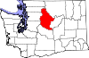
The Colville Indian Reservation is an Indian reservation in the north-central part of the U.S. state of Washington, inhabited and managed by the Confederated Tribes of the Colville Reservation, which is recognized by the United States of America as an American Indian Tribe. The reservation is located in the southeastern section of Okanogan County and the southern half of Ferry County, but there are pieces of trust land out Eastern Washington, including lands located in Chelan County, just to the northwest of the city of Chelan. The reservation's name is adapted from that of Fort Colville, which was named for Andrew Colville, a London governor of the Hudson's Bay Company and had been founded before the region became part of the United States.
The Confederated Tribes have 8,700 descendants from 12 aboriginal tribes. The tribes are known in English as: the Colville, the Nespelem, the Sanpoil, the Lakes (after the Arrow Lakes of British Columbia or Sinixt), the Palus, the Wenatchi, the Chelan, the Entiat, the Methow, the southern Okanagan, the Sinkiuse-Columbia, and the Nez Perce of Chief Joseph's Band. Some members of the Spokane tribe also settled the Colville reservation later on. The full origin of the adoption of the name "Colville" tribe are unknown since the name only goes back to the founding of the reservation (Tribal members may also find it offensive to be called Colville). The most common of the indigenous languages spoken on the reservation is Colville-Okanagan, a Salishan language. Other tribes speak other Salishan languages, with the exception of the Nez Perce and Palus, who speak Sahaptian languages.
Outsiders often named the Colville Scheulpi or Chualpay; the French traders called them Les Chaudières ("the kettles") in reference to Kettle Falls.
Contents
History
Prior to the influx of British and Americans in the mid-1850s the ancestors of the 12 aboriginal tribes followed seasonal cycles of food availability; moving to the rivers for fish runs, mountain meadows for berries and deer, or the plateau for roots. Their traditional territories were grouped primarily around waterways such as the Columbia, San Poil, Nespelem, Okanogan, Snake, and Wallowa rivers.
Many tribal ancestors ranged throughout their aboriginal territories and other areas in the Northwest (including British Columbia, Canada), gathering with other native peoples for traditional activities such as food harvesting, feasting, trading, and celebrations that included sports and gambling. Their lives were tied to the cycles of nature both spiritually and traditionally [1].
In the mid-19th century, when the settlers, squatters and trespassers began competing for trade with the indigenous native peoples, many tribes began to migrate westward. Trading became a bigger part of their lives.
Finally an ownership dispute began between Britain and the U.S. over what the latter called the Oregon Country and the former the Columbia District. Both claimed the territory until the Oregon Treaty of 1846 established American title south of the 49th Parallel; all of the indigenous people living in those territories were not considered citizens and were not regarded as entitled to the lands. However, according to the religions of the indigenous peoples, this territory had been their home land since the time of creation.
President Fillmore signed a bill creating the Washington Territory, and a Commissioner of Indian Affairs (Major Isaac Stevens of the United States Army Corps of Engineers) was appointed to meet with the "Indians" during his exploration for railroad routes. Stevens wrote a report recommending the creation of "reservations" for the people in the Washington Territory; stating "contrary to natural rights and usage," the United States should grant lands that would become reservations to the Indians without purchasing from them.
In 1854 "negotiations" were conducted, "particularly in the vicinity of white settlements, toward extinguishment of the Indian claims to the lands and the concentration of the tribes and fragments of tribes on a few reservations naturally suited to the requirement of the Indians, and located, so far as practicable, so as not to interfere with the settlement of the country."
During this time, continued settlement resulted in the Yakima War, which was fought from 1856 to 1859. Negotiations were unsuccessful until 1865, at which time Superintendent McKenny commented:
- "From this report, the necessity of trading with these Indians can scarcely fail to be obvious. They now occupy the best agricultural lands in the whole country and they claim an undisputed right to these lands. White squatters are constantly making claims in their territory and not infrequently invading the actual improvements of the Indians. The state of things cannot but prove disastrous to the peace of the country unless forestalled by a treaty fixing the rights of the Indians and limiting the aggressions of the white man. The fact that a portion of the Indians refused all gratuitous presents shows a determination to hold possession of the country here until the government makes satisfactory overtures to open the way of actual purchase."
President Grant issued an Executive Order on April 9, 1872, to create an "Indian Reservation" consisting of several million acres of land, containing rivers, streams, timbered forests, grass lands, minerals, plants and animals. People from 11 tribes, including the Colville, the Nespelem, the San Poil, Lakes, Palus, Wenatchi, Chelan, Entiat, Methow, southern Okanogan, and the Moses Columbia, were "designated" to live on the newly created Colville Indian Reservation.
The Presidential Executive Order issued on July 2, 1872 moved the Colville Indian Reservation west of the Columbia River, and reduced the size from several million to 2,852,000 acres (11,540 km²). The Tribes' native lands of the Okanogan River, Methow Valley, and other large areas of the Columbia and Pend d'Orielle Rivers, along with the Colville Valley, were excluded. The areas removed from the reservation were some of the richest.
Twenty years later Congress ceded the north half of the reservation under the Dawes Act. The federal government paid only $1.00 an acre ($247/km²). Later (October 10, 1900) 1,449,268 acres (5,865 km²) were opened to homesteading. Finally, in 1914, the south half of the Reservation was ceded.
Current
The reservation encompasses 2,116.802 sq mi (5,482.493 km²) in land area, consisting of: tribally owned lands held in federal trust status for the Confederated Tribes, land owned by individual Colville tribal members (most of which is held in federal trust status), and land owned by other tribal or non-natives, described as fee property and taxable by counties.
The reservation is occupied by 7,587 residents (2000 census), both Colville tribal members and their families and other non-Colville members, living either in small communities or in rural settings. Approximately fifty percent of the Confederated Tribes membership live on or adjacent to the reservation.
Major towns include Omak, Nespelem, Inchelium, Keller, and Coulee Dam.
The legislative districts of the reservation are divided up and named as such:
Omak District: The largest district by population, which makes up the northwestern portion of the reservation the Omak Okanogan Valley and half the town of Omak. The Okanogan River provides the border of the reservation within the city limits of Omak.
Nespelem District: Making up the west-central portion of the reservation in the Nespelem Valley and part of the city of Coulee Dam. The Reservation Headquarters is located on the Bureau of Indian Affairs Agency campus near the town of Nespelem. In Coulee Dam, the Columbia River also serves as a reservation border within the town limits.
Keller District: The district making up the east-central region of the reservation, namely the San Poil Valley to the mouth of the Columbia River, along a tributary, the San Poil River, and the edge of the man-made Lake Roosevelt.
Inchelium District: Makes up the north-eastern most region of the reservation.
In 1997 and 1998, the Colville Confederated Tribes celebrated its 125th anniversary of the signing of the Executive Order that created the reservation.
Communities
- Coulee Dam (part, population 915)
- Elmer City
- Inchelium
- Keller
- Nespelem
- Nespelem Community (Agency area)
- North Omak
- Okanogan (a small part, population 2)
- Omak (part, population 742)
Government
The Confederated Tribes and the Colville Indian Reservation are governed by the Colville Business Council[1] From its administrative headquarters located at the Bureau of Indian Affairs (BIA) Agency at Nespelem, the Colville Business Council oversees a diverse, multi-million dollar administration that employs from 800 to 1,200 individuals in permanent, part-time, and seasonal positions. The Colville Business Council is composed of members who are elected to a renewable two-year term of office. There are four council members for each district, except for the Keller District (which has two). Each year, half of the Business Council seats in each district are up for election. Elections are held mid-June, with votes cast in person at polling sites at a predesignated location (usually the local community center) or by absentee ballot.
Education
The current education system set for the Colville Indian Reservation is that each town on the reservation has its own K-6 school either directly or partially affiliated with the tribes. The Omak and Okanogan school districts serve the students of that area from Kindergarten-12. The Nespelem school district has a Kindergarten-8 system; most Nespelem students attend high school at nearby Lake Roosevelt High School in the town of Coulee Dam. The Keller school district serves students from Kindergarten-6 and gives students the option of attending junior and senior high school at relatively nearby Wilbur High School, Lake Roosevelt High School or Republic High School. Due to historically negative perceptions, the predominantly European-American town of Republic is rarely attended by students from Keller, though these perceptions exist within the Wilbur, Coulee Dam, and other towns neighboring the reservation.
Pascal Sherman Indian School located outside of Omak at St. Mary's Mission is the only Native American residential school on the reservation currently serving grades pre-Kindergarten-to-9 although there are ongoing plans to include a high school. Inchelium School district and Lake Roosevelt High School are the only public Kindergarten-12 schools within the physical boundaries of the reservation.
There are currently only a few options for one to pursue a post-secondary education on the reservation. The Community Colleges of Spokane have an outreach campus in Inchelium. Big Bend Community College has a similar campus in Grand Coulee. Spokane Tribal College has a joint venture on Nespelem's Agency Campus. Wenatchee Valley College North Campus is located in Omak.
Many students from the reservation typically attend four-year college at Eastern Washington University, Washington State University, Central Washington University, Gonzaga University (which was first opened to service Native Americans) or University of Washington. Heritage College also offers some courses and degrees in Omak at the Wenatchee Valley College-North Campus building.
Legends and stories
- Coyote and the buffalo- Colville legend about why buffalo don't live near Kettle Falls.
- Coyote quarrels with mole- Colville legend about coyote fighting with his wife.
- Spirit chief names the animal people- Colville legend about the naming of the Chip-chap-tiqulk.
- Turtle and the eagle- Colville folktale about turtle winning a race.
References
- ^ Colville Business Council Confederation Tribes of the Colville Reservation. Accessed 2009-10-05.
- Colville Reservation and Off-Reservation Trust Land, Washington United States Census Bureau
External links
- Official site of the Colville Confederated Tribes
- Colville Business (Tribal) Council
- The Colville.
- Colville Tribal Enterprises Corporation
- Okanagan Nation Alliance (includes the Colville Confederated Tribes as well as Okanagans in Canada).
- Ceremony marks return of salmon, tradition to Colville Reservation- Natural Resources Conservation Service, Washington
Coordinates: 48°13′47″N 118°52′22″W / 48.22972°N 118.87278°W
First Nations governments of the Okanagan Nation Alliance Lower Similkameen Indian Band · Okanagan Indian Band · Osoyoos Indian Band · Penticton Indian Band · Upper Nicola Indian Band · Upper Similkameen Indian Band · Westbank First Nation · Colville Indian Reservation (WA)Municipalities and communities of Okanogan County, Washington Cities 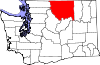
Towns Conconully | Coulee Dam ‡ | Elmer City | Nespelem | Riverside | Twisp | Winthrop
CDPs Unincorporated
communitiesIndian reservation Colville Indian Reservation‡
Ghost towns Footnotes ‡This populated place also has portions in an adjacent county or counties
Municipalities and communities of Ferry County, Washington City 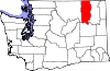
CDP Communities Indian reservation Colville Indian Reservation‡
Footnotes ‡This populated place also has portions in an adjacent county or counties
Municipalities and communities of Chelan County, Washington Cities Cashmere | Chelan | Entiat | Leavenworth | Wenatchee
CDPs Unincorporated
communitiesAppleyard | Ardenvoir | Blewett | Chelan Falls | Chiwaukum | Chumstick | Dryden | Grant Road Addition | Holden Village | Kenroy | Lakeside | Lucerne | Malaga | Manson | Merritt | Mission Square | Monitor | Pearcot | Peshastin | Plain | Stehekin | Telma | Wenatchee Heights | Winton
Indian reservation Colville Indian Reservation‡
Footnotes ‡This populated place also has portions in an adjacent county or counties
Categories:- American Indian reservations in Washington (state)
- Syilx
- Native American tribes in Washington (state)
- Sinixt
- Geography of Chelan County, Washington
- Geography of Ferry County, Washington
- Geography of Okanogan County, Washington


Wikimedia Foundation. 2010.