- U.S. Route 10
Infobox U.S. Route
article_route=10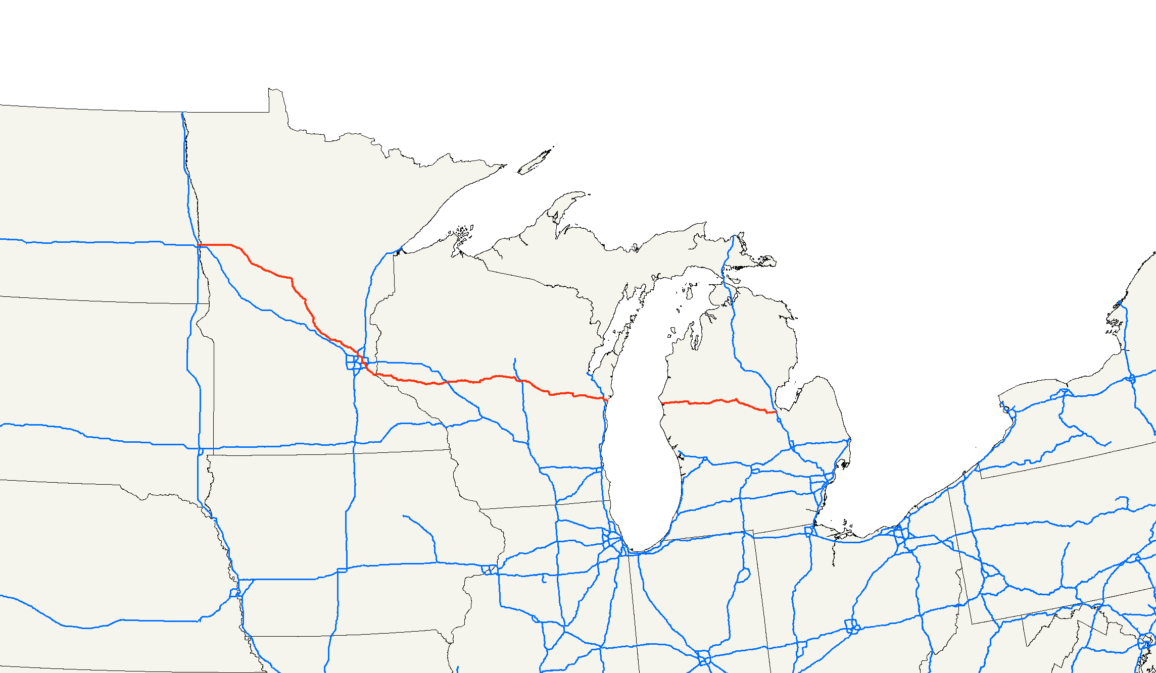
length_mi=565
length_ref= [http://www.us-highways.com/us1830.htm US Highways From US 1 to US 830] Robert V. Droz]
length_km=909.2
yrcom=1926
direction_b=East
direction_a=West
from=Jct|state=ND|I|94|BL|94|dab2=Fargo|US|52 at West Fargo, ND
junction=Jct|state=ND|I|29 in Fargo, ND
jct|state=MN|I|35|I|94 in St. Paul, MN
Jct|state=MN|US|61 in Cottage Grove, MN
Jct|state=WI|I|94 in Osseo, WI
Jct|state=WI|I|39|US|51 in Stevens Point, WI
Jct|state=WI|US|41 in Menasha, WI
Jct|state=WI|I|43 near Manitowoc, WI
Jct|state=MI|US|31 near Ludington, MI
Jct|state=MI|US|131 near Reed City, MI
Jct|state=MI|US|127 near Clare, MI
to=Jct|state=MI|I|75|BS|75|dab2=Bay City|US|23|MI|25 in Bay City, MIU.S. Route 10 is an east-west
United States highway formed in 1926.Droz, Robert V. [http://www.us-highways.com/usbt.htm U.S. Highways : From US 1 to (US 830)] . URL accessed 22:46, 20 February 2006 (UTC).] Though it was never the cross-country route suggested by the "0" in its route number, US 10 was once one of the original long-haul highways, fromDetroit, Michigan , toSeattle, Washington , before losing much of its length to theInterstate highway s.As of 2006 , it is convert|565|mi|km long.The route crosses
Lake Michigan by ferry (theSS Badger ) betweenLudington, Michigan , andManitowoc, Wisconsin . US 10 is one of only two US Highways that include a ferry ride in the route (US 9 is the other). Formerly, US 16 also had a ferry connection betweenMuskegon, Michigan , andMilwaukee, Wisconsin ; ferry service on this route was restored and now runs as theLake Express . All U.S. Highway ferries may be eliminated if long tunnels or bridges are constructed to supplant them.As of 2004, the highway's eastern terminus is in
Bay City, Michigan , at an intersection withInterstate 75 (US-10 mile marker 139, I-75 mile marker 162). Its western terminus is inWest Fargo, North Dakota at an intersection withInterstate 94 .cite web |url=http://www.geocities.com/usend1019/End010/end010.htm Endpoints of US highways |author=Mapguy |date=2006-09-06 |accessdate=2006-12-20 |title=End of U.S. Highway 10]Route description
North Dakota
In the state of
North Dakota , U.S. 10 runs approximately 8 miles (13 km), fromInterstate 94 to the Red River. It is one of the primary east-west streets in West Fargo and Fargo, and is called Main Avenue for its entire length in North Dakota. At the Red River, U.S. 10 crosses over a bridge toMoorhead, Minnesota .Minnesota
US 10 is a major
divided highway for almost all of its length inMinnesota .Wisconsin
U.S 10 Enters Wisconsin at Prescott and treks southeastward passing Neillsville, Marshfield, Stevens Point, Appleton before meeting the S.S. Badger carferry in Manitowoc.
Michigan
U.S. Highway 10 enters
Michigan after it crossesLake Michigan from Manitowoc to Ludington. U.S. 10 is concurrent with U.S. 31 from Ludington to Scottville before Highway 31 heads north. The road then heads east through Baldwin and Reed City before it becomes afreeway west of U.S. 127 near the junction with highway M-115. U.S. 127 and U.S. 10 overlap for a short distance near Clare. U.S. 10 bypasses Midland and terminates at I-75 in Bay City. [cite web|url=http://www.michiganhighways.org/listings/MichHwys10-19.html#US-010|title=US-10|work=MichiganHighways.org|last=Bessert|first=Christopher J.]Alternate routes
US 10 has had alternate routes designated in the past, but none are active as of 2004.
Between 1926 and 1934, there was a pair of alternate routes between
St. Cloud, Minnesota andMoorhead, Minnesota . U.S. Route 10N, the northern route, connected St. Cloud,Little Falls, Minnesota ,Motley, Minnesota , andDetroit Lakes, Minnesota before reaching Moorhead. U.S. Route 10S ran from St. Cloud throughAlexandria, Minnesota andFergus Falls, Minnesota before rejoining U.S. Route 10N at Moorhead. In the mid-1930s,U.S. Route 52 was extended into Minnesota, and Route 10S was renamed to Route 52 (nowInterstate 94 ). Route 10N was renamed to Route 10. cite web |author=Riner, Steve |title=The Unfficial Minnesota Highways Page: Details of Routes 1-25 |url=http://www.steve-riner.com/mnhighways/r1-25.htm#10 |accessdate=2006-04-05]History
Originally, US 10 also passed through
Montana , theIdaho Panhandle , andWashington , terminating in Seattle. The completion of I-90 and I-94 replaced US 10 along this route, although some sections of the old US 10 road still exist in such cities asBismarck, North Dakota ,Missoula, Montana andSpokane, Washington . The last section of Interstate 90 to be completed was betweenWallace, Idaho andCoeur d'Alene, Idaho in the early 1990s. Much of this route was co-numbered as both Interstate 90 and US 10 until the final completion of Interstate 90 through Idaho.At the eastern end, US 10 originally went south from
Midland, Michigan toSaginaw, Michigan on what is now highway M-47. It then joined up with US 23 in Saginaw, and continued south until it split from US 23 north ofFlint, Michigan . It then continued south-east as theDixie Highway toPontiac, Michigan , where it becameWoodward Avenue , now designated as M-1. From there, US 10 continued on an almost straight line to downtownDetroit , where it intersected with US 16, US 25, and US 12. It then took a two-block jog, and ended up at theDetroit-Windsor Tunnel toCanada .In the 1970's, US-10 was rerouted off
Woodward Avenue in the Detroit area and onto theJohn C. Lodge Freeway (formerly Business Spur 696) and Telegraph Road. US-10 was truncated to Bay City, Michigan in 1987 at which point the Lodge Freeway was changed to M-10.In 1925, US-10 was originally proposed to run from Detroit through
Chicago , and northwesterly into Wisconsin on what later became US-12.ee also
*
U.S. Route 10 in Wisconsin
*U.S. Route 110
*U.S. Route 210
*U.S. Route 310
*U.S. Route 410
*Washington State Route 10 , a convert|16|mi|km|sing=on segment of old U.S. Route 10References
External links
* [http://www.geocities.com/usend1019/End010/end010.htm US-10 endpoint photos]
* [http://www.state-ends.com/michigan/us/12/ Proposed 1925 Michigan US-10 endpoints (became US-12)] ]
* [http://www.state-ends.com/michigan/us10/ Michigan US-10 endpoints]
* [http://www.state-ends.com/michigan/m/m-1.htm Former US-10 Southern Terminus (now M-1)]
* [http://www.state-ends.com/michigan/m10/ Former US-10 Southern Terminus (now M-10)]###@@@KEYEND@@@###
Wikimedia Foundation. 2010.