- Liberty Lake, Washington
-
Liberty Lake, Washington — City — Location of Liberty Lake, Washington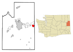
Coordinates: 47°39′22″N 117°5′11″W / 47.65611°N 117.08639°WCoordinates: 47°39′22″N 117°5′11″W / 47.65611°N 117.08639°W Country United States State Washington County Spokane Area – Total 5.3 sq mi (13.8 km2) – Land 4.3 sq mi (11.1 km2) – Water 1.1 sq mi (2.8 km2) Elevation 2,073 ft (632 m) Population (2010) – Total 7,591 – Density 1,091.8/sq mi (421.5/km2) Time zone Pacific (PST) (UTC-8) – Summer (DST) PDT (UTC-7) ZIP code 99019 Area code 509 FIPS code 53-39335[1] GNIS feature ID 1512389[2] Liberty Lake is an incorporated city in Spokane County, Washington, United States, on the Idaho state line. Liberty Lake is a suburb of Spokane, Washington. Thus, it is situated between Spokane and Coeur d'Alene, Idaho. The population was 7,591 at the 2010 census.
Liberty Lake was named after an Etienne Edward Laliberte (A French Canadian-1871), later he changed his name to Steve Liberty, a mail carrier and homesteader by the Lake.
Based on per capita income, one of the more reliable measures of affluence, Liberty Lake ranks 42nd of 522 areas in the state of Washington to be ranked. It is also the highest rank achieved in Spokane County.
Contents
History
Liberty Lake was officially incorporated on August 31, 2001. The lake itself is located outside of the city limits as it is outside the urban growth boundary.
Geography
Liberty Lake is located at 47°39′22″N 117°5′11″W / 47.65611°N 117.08639°W (47.656171, -117.086287).[3]
According to the United States Census Bureau, the CDP has a total area of 5.3 square miles (13.8 km²), of which, 4.3 square miles (11.1 km²) of it is land and 1.1 square miles (2.8 km²) of it (20.04%) is water.
Liberty Lake is one of the fastest growing communities in the State of Washington. Liberty Lake is south of the Spokane River from Otis Orchards-East Farms, Washington, east of Greenacres, Washington (now part of Spokane Valley, Washington), and west of Post Falls, Idaho.
Demographics
As of the census[1] of 2000, there were 4,660 people, 1,771 households, and 1,347 families residing in the CDP. The population density was 1,091.8 people per square mile (421.4/km²). There were 1,894 housing units at an average density of 443.7 per square mile (171.3/km²). The racial makeup of the CDP was 93.69% White, 0.71% African American, 0.28% Native American, 2.60% Asian, 0.15% Pacific Islander, 0.56% from other races, and 2.02% from two or more races. Hispanic or Latino of any race were 2.23% of the population.
There were 1,771 households out of which 39.6% had children under the age of 18 living with them, 68.4% were married couples living together, 5.3% had a female householder with no husband present, and 23.9% were non-families. 19.7% of all households were made up of individuals and 4.7% had someone living alone who was 65 years of age or older. The average household size was 2.63 and the average family size was 3.05.
In the CDP, the age distribution of the population shows 29.1% under the age of 18, 4.8% from 18 to 24, 33.1% from 25 to 44, 24.7% from 45 to 64, and 8.4% who were 65 years of age or older. The median age was 36 years. For every 100 females there were 98.5 males. For every 100 females age 18 and over, there were 94.8 males.
The median income for a household in the CDP was $60,854, and the median income for a family was $66,985. Males had a median income of $57,425 versus $30,828 for females. The per capita income for the CDP was $29,105. About 1.3% of families and 3.2% of the population were below the poverty line, including 2.7% of those under age 18 and 6.4% of those age 65 or over.
Community
Only part of the community is within the City of Liberty Lake, incorporated on August 31, 2001. The city has an official population of 4,480 as of April 1, 2002, having grown nearly 25% in the previous year. The city's population as of December 31, 2002, rose to 5,030. Approximately 1,400 Liberty Lake residents live outside the city limits.
The city operates on a City Council system. As of spring 2011, city council members are as follows: Mayor: Wendy Van Orman, Position 1: Susan Schuler, Position 2: Josh Beckett, Position 3: David Crump, Position 4: Odin Langford, Position 5: Judi Owens, Position 6: Ryan Romney, Position 7: Cris Kaminskas[4]
References
- ^ a b "American FactFinder". United States Census Bureau. http://factfinder.census.gov. Retrieved 2008-01-31.
- ^ "US Board on Geographic Names". United States Geological Survey. 2007-10-25. http://geonames.usgs.gov. Retrieved 2008-01-31.
- ^ "US Gazetteer files: 2010, 2000, and 1990". United States Census Bureau. 2011-02-12. http://www.census.gov/geo/www/gazetteer/gazette.html. Retrieved 2011-04-23.
- ^ "City Council Members". The City of Liberty Lake. Spokane Web Communications. http://www.libertylakewa.gov/council/city_council_members.asp. Retrieved May 2, 2011.
External links
Municipalities and communities of Spokane County, Washington Cities Airway Heights | Cheney | Deer Park | Liberty Lake | Medical Lake | Spokane | Spokane Valley
Towns CDPs Unincorporated
communitiesAmber | Chattaroy | Colbert | Elk | Green Bluff | Marshall | Mead | Mica | Milan | Newman Lake | Nine Mile Falls | Valleyford
Categories:- Cities in Washington (state)
- Populated places in Spokane County, Washington
- Former census-designated places in Washington (state)


Wikimedia Foundation. 2010.