Washington State Route 19
- Washington State Route 19
Infobox WA State Route|type=State|route=19|sec=077|formed=1992
length_mi=14.09
length_ref=
length_round=2
dir1=South
dir2=North
from=
junction=
to=
next_type=State|previous_type=State|next_route=20|previous_route=18
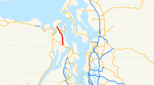
State Route 19 is a highway in the state of Washington, U.S.A. It extends about 14 miles from
SR 104 just west of the Hood Canal Bridge to SR 20 south of Port Townsend.
In Washington, 2-digit highways generally follow the same numbering pattern as Interstate highways: odd-numbered routes run north-south, with the lowest-numbered highways in the western part of the state and the highest-numbered highways in the east. SR 19, a relatively recent addition to the state highway system, diverges from this pattern significantly, being located on the Olympic Peninsula longitudinally west of SR 3, the lowest-numbered north-south highway in the state.
Major intersections
The entire route is in Jefferson County.
References
External links
* [http://www.angelfire.com/wa2/hwysofwastate/sr019.html Highways of Washington State]
Wikimedia Foundation.
2010.
Look at other dictionaries:
Washington State Route 20 — State Route 20 Whidbey Scenic Isle Way North Cascades Highway … Wikipedia
Washington State Route 31 — State Route 31 Nearby state routes with SR 31 highlighted in red. Route inform … Wikipedia
Washington State Route 20 — (SR 20) Autres noms North Cross Highway Longueur 701,87 … Wikipédia en Français
Washington State Route 14 — La State Route 14, également appelée Lewis and Clark Highway, est une route d État dans l État de Washington, aux États Unis. Elle s étend sur environ 290 kilomètres à partir de sa jonction avec l autoroute Interstate 5 à Vancouver dans l… … Wikipédia en Français
Washington State Route 27 — infobox WA State Route type=State route=27 sec=115 length mi=90.00 length ref= length round=2 formed=1964 dir1=South dir2=North from= junction= to= in Spokane Valley previous type=State previous route=26 next type=State next route=28State Route… … Wikipedia
Washington State Route 16 — Karte … Deutsch Wikipedia
Washington State Route 12 — Several highways in the U.S. state of Washington have been numbered 12: *U.S. Route 12 in Washington *Washington State Route 12 (1964 1967), now SR 14 *Primary State Highway 12 (Washington) (1937 1970) and State Road 12 (Washington 1923 1937),… … Wikipedia
Washington State Route 525 — State Route 525 Whidbey Scenic Isle Way … Wikipedia
Washington State Route 524 Spur — State Route 524 Spur may refer to:*State Route 524 Spur (Edmonds, Washington), Third Avenue and Pine Street in Edmonds, Washington *State Route 524 Spur (Lynnwood, Washington), 44th Avenue W in Lynnwood, Washingtonee also*Washington State Route… … Wikipedia
Washington State Route 504 — La State Route 504, également appelée Spirit Lake Memorial Highway, est une route d État dans les comtés de Cowlitz et de Skamania, dans l État de Washington, aux États Unis. Elle s étend sur environ 83,3 kilomètres et effectue une jonction… … Wikipédia en Français
Washington State Route 14 — State Route 14 Route information D … Wikipedia
