- Interstate 182
Infobox road
state=WA
route=182
type=I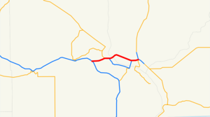
maint=WSDOT
section=372
length_mi=15.19
length_round=2
length_ref=Washington State Department of Transportation , [http://www.wsdot.wa.gov/mapsdata/TDO/PDF_and_ZIP_Files/HwyLog2006.pdf State Highway Log] , 2006]
year_established=1986
direction_a=West
terminus_a=Jct|state=WA|I|82|US|12 near Richland
junction=Jct|state=WA|SR|240 in Richland Jct|state=WA|US|395 in Pasco
direction_b=East
terminus_b=Jct|state=WA|US|12 in Pasco
previous_type=WA
previous_route=181
next_type=WA
next_route=193
commons=categoryInterstate 182 (I-182) is a convert|15.19|mi|km|2|sing=on|lk=on Interstate Highway that extends from I-82 west of Richland to US 12 in Pasco. It serves the Tri Cities.cite map |publisher=
Google Maps |title=Map of I-182 |url=http://maps.google.com/maps?f=d&saddr=46.244332,-119.35813&daddr=I-182+E%2FUS-12+E+%4046.250591,+-119.074783&hl=en&geocode=2030258381468926231,46.244805,-119.353300%3B1681659664576368145,46.250591,-119.074783&mra=dme&mrcr=0&mrsp=0&sz=14&sll=46.24641,-119.355297&sspn=0.018104,0.035706&ie=UTF8&ll=46.262968,-119.214706&spn=0.144787,0.285645&z=11 |cartography=NATVEQ |year=2008 |accessdate=2008-08-22] [cite map |title=Official State Highway Map |url=http://www.wsdot.wa.gov/NR/rdonlyres/87105CAD-83A9-49A7-80F3-5719637C1E2D/0/FrontMapBig.pdf |publisher=Washington State Department of Transportation |location=Olympia, Washington |year=2008 |edition=2008-2009 |scale=1:842,000 |series=Official State Highway Maps |cartography=U.S. Geological Survey |accessdate=2008-08-07] [cite map |publisher=GM Johnson |location=Burnaby ,British Columbia |title=Washington Large Print |url=http://store.maplink.com/map.aspx?nav=MS&cid=10056,10078&pid=538387 |year=2007 |edition=2007 |series=GM Johnson Large Print State Maps |accessdate=2008-08-08] The whole length of I-182 is concurrent with US 12, which extends westwards to Yakima, Naches, and Aberdeen and extends eastwards to Walla Walla, Lewiston, ID, Chicago, IL, and Detroit, MI. I-182 also is the only auxiliary Interstate spur ofInterstate 82 .The freeway is the least busiest in the
Washington , behind I-5 at 240,000,cite web |url=http://www.wsdot.wa.gov/mapsdata/tdo/PDF_and_ZIP_Files/Annual_Traffic_Report_2007.pdf |title=Washington Annual Average Daily Traffic Data |author=Washington State Department of Transportation |year=2007 |accessdate=2008-08-26] I-405 at 201,000, I-90 at 148,000, Interstate 205 at 136,000, Interstate 705 at 67,000, and I-82 at 43,000. An estimated 43,000 motorists utilize the road daily in Washington.Route description
I-182 starts at an interchange with I-82/US 12 west of Richland. Then, the freeway, now concurrent with US 12, goes 3 miles east into Richland, where I-182/US 12 become concurrent with SR 240 for one mile, and then SR 240 splits south into Kennewick, meanwhile I-182/US 12 goes over the
Columbia River on theInterstate 182 Bridge into Pasco.Within Pasco, I-182/US 12 passes the
Broodmoor Mall and continues southeast into Downtown Pasco, where the freeway joins US 395 and passes theColumbia Basin College andTri-Cities Airport . At an interchange with SR 397, US 395 exits off and goes north towards Spokane and I-182 ends shortly after the interchange. From the ending of I-182, US 12 continues ontoLewiston, Idaho . [cite map |publisher=Rand McNally |title=The Road Atlas |year=2008 |page=108 |isbn=0528939610] [cite map |title=Official State Highway Map |url=http://www.wsdot.wa.gov/NR/rdonlyres/87105CAD-83A9-49A7-80F3-5719637C1E2D/0/FrontMapBig.pdf |publisher=Washington State Department of Transportation |location=Olympia, Washington |year=2008 |edition=2008-2009 |scale=1:842,000 |series=Official State Highway Maps |cartography=U.S. Geological Survey |section=G6 |accessdate=2008-08-08] [cite map |publisher=GM Johnson |location=Burnaby ,British Columbia |title=Yakima, Yakima County Wineries |url=http://store.maplink.com/map.aspx?nav=MS&cid=10056,10078&pid=523006 |year=2008 |edition=2008 |series=City Street Map |accessdate=2008-08-08] [cite web |url=http://www.wsdot.wa.gov/Traffic/InterstateGuide/i82/I82_GrangerToOreBorder.htm |title=WSDOT Interchange Viewer - Interstate 182 |author=Washington State Department of Transportation |accessdate=2008-08-10]History
As part of
Washington 's first connected state highway system, theWashington State Legislature designated theInland Empire Highway between Ellensburg and |year=1939 |accessdate=2008-08-26]When I-82 was approved in 1956, the Tri-Cities wanted an Interstate, since Interstate 82 bypassed the cities. Interstate 182 was the solution and created a connection to the Tri-Cities. Legally, I-182 is defined at Washington Revised Code § 47.17.372. [cite web |url=http://apps.leg.wa.gov/RCW/default.aspx?cite=47.17.372 |title=RCW 47.17.372: State route No. 182 |author=
Washington State Legislature |accessdate=2008-08-10] 2 projects are currently ongoing on I-182. [cite web |url=http://www.wsdot.wa.gov/Projects/I182/ |title=WSDOT - Construction Projects on Interstate 182 |author=Washington State Department of Transportation |accessdate=2008-08-11]Exit list
References
External links
* [http://www.interstate-guide.com/i-182_wa.html Interstate 182 @ Interstate-Guide.com]
* [http://www.angelfire.com/wa2/hwysofwastate/i182.html Highways of Washington State]

Wikimedia Foundation. 2010.