- Washington State Route 240
infobox WA State Route
type=WA
route=240
sec=455
parent=24
parent_type=WA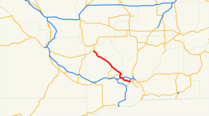
length_mi=41.34
length_ref=
length_round=2
formed=1964
dir1=West
dir2=East
from=
junction= in Richland
to=
previous_type=WA
previous_route=231
next_type=WA
next_route=241State Route 240 is a busy
state highway servicing the Tri-Cities ofWashington and theHanford Site . Its eastern end begins at the southern end of the Blue Bridge in centralKennewick as an offshoot of U.S. Route 395. It continues as afreeway through northern Kennewick just south of theColumbia River —passing near theColumbia Center Mall on the way—all the way up to Richland, where it effectively enters into town as the heavily-traveled George Washington Way at the interchange with Interstate 182. However, it is possible to continue on the highway (though it is no longer a freeway after the Interstate 182 interchange) by taking an exit and traveling around the west side of town—the highway is known for that stretch of land as the "Bypass Highway". This name, given when the highway actually avoided most of therush-hour gridlock and constantstoplight s of George Washington Way, is somewhat ironic nowadays as the six stoplights on this section of the highway impede drivers just as the traffic-laden main street has for decades.In any case, after traveling north for roughly five miles, the road itself continues northward as Stevens Drive, but the highway itself goes on as an offshoot, this time heading to the northwest. The highway enters the
Hanford Nuclear Reservation and goes on for dozens of miles. Eventually, it ends in State Route 24. Going north onto Highway 24 leads to Interstate 90 andGeorge, Washington ; going west instead leads toYakima, Washington .Due to the heavy traffic pressed upon the highway during rush hour, the road underwent significant
construction from the Columbia Center Boulevard exit in Kennewick all the way up through the first mile or so of George Washington Way. This included demolition of the fifty year-old four-lane bridge that spanned theYakima River , where in its place two four-lane bridges were constructed. A more controversial change came at the eastbound exit to Columbia Park Trail, where a two-laneroundabout intersection - which connects the exit, Columbia Park Trail and Steptoe Avenue - was constructed. The work was completed in early June of2007 , several months ahead of schedule.Major intersections
The entire route is in Benton County.
References
* [http://apps.leg.wa.gov/RCW/default.aspx?cite=47.17.455 RCW 47.17.455: Legal definition of SR 240]
* [http://www.wsdot.wa.gov/Projects/SR240/YakimaRiverBridge/ Yakima River Bridge Project]
* [http://www.wsdot.wa.gov/Projects/SR240/TriCitiesAddLanes/ Tri-Cities Additional Lanes Project]

Wikimedia Foundation. 2010.