- Washington State Route 124
Infobox road
state=WA
type=SR
route=124
alternate_name=Ice Harbor Drive
maint=WSDOT
section=235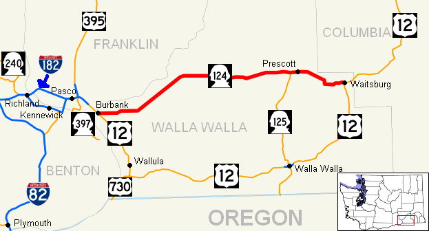
map_notes=SR 124 highlighted in red
length_mi=44.68
length_round=2
length_ref=cite web|author=Washington State Department of Transportation |url=http://www.wsdot.wa.gov/mapsdata/tdo/PDF_and_ZIP_Files/HwyLog2006.pdf|title=State Highway Log, 2006|accessdate=2008-08-30]
established=1964cite web |url=http://apps.leg.wa.gov/RCW/default.aspx?cite=47.17.235 |title=RCW 47.17.235: State Route 124 |accessmonthday=July 11 |accessyear=2008 |author=Washington State Legislature ] Session Laws of the State of Washington. 1964 Title 47, Chapter 47.17, Section 47.17.235. "A state highway to be known as state route number 124 is established as follows: Beginning at a junction with state route number 12 in the vicinity of Burbank, thence northeasterly by the most feasible route to a point in the vicinity of Eureka, thence easterly by the most feasible route to a junction with state route number 125 in the vicinity of Prescott, thence easterly to a junction with state route number 12 in the vicinity northeast of Waitsburg."]
direction_a=West
terminus_a=jct|state=WA|US|12 in Burbank
junction=jct|state=WA|SR|125 near Prescott
direction_b=East
terminus_b=jct|state=WA|US|12 in Waitsburg
previous_type=SR
previous_route=123
next_type=SR
next_route=125
spur_of=12
spur_type=USState Route 124 (SR 124) is a
state highway in theU.S. state ofWashington . It extends convert|44.68|mi|km|2 from US 12 in Burbank, east to US 12 in Waitsburg. The route serves as a bypass of Walla Walla and as a connector from US 12 to Prescott.cite map |publisher=Google Maps |title=State Route 124 Overview Map |url=http://maps.google.com/maps?f=d&saddr=WA-124+%4046.209599,+-119.013303&daddr=46.270159,-118.153238&hl=en&geocode=7635730936274647139,46.209599,-119.013303%3B&mra=mi&mrsp=1,0&sz=18&sll=46.269903,-118.153195&sspn=0.001124,0.002232&ie=UTF8&ll=46.217852,-118.627625&spn=0.575815,1.142578&z=9 |year=2008 |cartography=NATVEQ |accessdate=2008-08-30] SR 124 was established in 1964 after the 1964 highway renumbering, along its current route. Before SR 124 was established, the route from Burbank to SR 125 wasSecondary State Highway 3D and the route from SR 125 to Waitsburg wasSecondary State Highway 3E .Even though SR 124 was established in 1964, no signs went up until the law that made SR 124 was approved by the
Washington State Legislature in 1970. The section of SR 124 from Bubrank to Ice Harbor Road is officially designated the Ice Harbor Drive, named after theIce Harbor Lock and Dam .Session Laws of the State of Washington. 1964 Title 47, Chapter 47.17, Section 47.17.235. "That portion of state route number 124 lying between the junction with state route number 12 and the county road to Ice Harbor Dam to be known as "Ice Harbor Drive"."] The portion of SR 124 from Piper Canyon Road to Waitsburg is designated as part of theLewis and Clark National Historic Trail , which runs fromHartford, Illinois toAstoria, Oregon .cite map |title=Map of the Lewis and Clark National Historic Trail |url=http://www.nps.gov/lecl/planyourvisit/upload/lecl%20map.pdf |publisher=National Park Service |date=2006-08-21 |accessdate=2008-09-01]Route description
State Route 124 runs approximately convert|44.68|mi|km|2 from US 12 in Burbank, east to US 12 in Waitsburg. The route links the communities of Burbank, Prescott, and Waitsburg. The road intersects two major arterials: US 12 before ending at State Route 124. [cite map |title=Official State Highway Map |url=http://www.wsdot.wa.gov/NR/rdonlyres/87105CAD-83A9-49A7-80F3-5719637C1E2D/0/FrontMapBig.pdf |publisher=
Washington State Department of Transportation |location=Olympia, Washington |year=2008 |edition=2008-2009 |scale=1:842,000 |series=Official State Highway Maps |cartography=U.S. Geological Survey |section=7G |accessdate=2008-08-30] [cite map |publisher=Rand McNally |title=The Road Atlas |year=2008 |page=108 |section=K15 |isbn=0528939610] [cite map |publisher=Rand McNally |title=The Road Atlas |year=2008 |page=108 |section=K16 |isbn=0528939610] [cite map |publisher=Rand McNally |title=The Road Atlas |year=2008 |page=108 |section=K17 |isbn=0528939610]SR 124 (Ice Harbor Drive) starts at an intersection with US 12 in northern Burbank and then goes northeast next to
Hood Park and theSnake River before turning east past Burbank Heights to intersect Ice Harbor Road. At this point, the Ice Harbor Drive designation is given to Ice Harbor Road, which continues to the actual dam and lock, about convert|2.70|mi|km from the intersection. [cite map |publisher=Google Maps |title=Ice Harbor Road Map |url=http://maps.google.com/maps?f=d&saddr=46.215242,-118.906773&daddr=Ice+Harbor+Rd+%4046.246210,+-118.878920&hl=en&geocode=%3B3629248267514039476,46.246210,-118.878920&mra=mi&mrsp=0,1&sz=18&sll=46.215391,-118.906816&sspn=0.001125,0.002232&ie=UTF8&ll=46.231866,-118.893185&spn=0.03598,0.071411&z=13 |year=2008 |cartography=NATVEQ |accessdate=2008-08-30] From the intersection the highway turns northeast past Slater, Ash, and Welland before continuing east past Eureka, Lamar, and Harsha before intersecting SR 125. [cite map |publisher=Google Maps |title=State Route 124 Map (Burbank to SR 125) |url=http://maps.google.com/maps?f=d&saddr=WA-124+%4046.209776,+-119.013049&daddr=46.298678,-118.340907&hl=en&geocode=7945002664735784771,46.209776,-119.013049%3B&mra=mi&mrsp=1,0&sz=15&sll=46.299212,-118.342795&sspn=0.008984,0.017853&ie=UTF8&ll=46.242552,-118.701782&spn=0.575555,1.142578&z=9 |year=2008 |cartography=NATVEQ |accessdate=2008-08-30] From the intersection with SR 125, the highway goes east into Prescott, where SR 124 starts to parallel the route of thePalouse River and Coulee City Railroad , a railroad that runs from Wallula to Walla Walla, Oregon, Waitsburg, and Dayton. [cite map |title=Washington State Railroad System |url=http://www.wsdot.wa.gov/NR/rdonlyres/8CFBC47D-3549-4CB9-9DE6-14CE9739671F/0/RailSystemMap_Aug2007.pdf |publisher=Washington State Department of Transportation |year=2007 |month=August |cartography=U.S. Geological Survey |accessdate=2008-08-30] [cite web |url=http://www.wsdot.wa.gov/Freight/Rail/railroadsContacts.htm |title=Railroad Contacts in Washington State |author=Washington State Department of Transportation |accessdate=2008-08-30] [cite web |url=http://www.watcocompanies.com/railroads.htm |title=Watco Companies Railroads |author=Watco Companies |accessdate=2008-08-30] After passing Robinson, the highway goes southeast and then south to Bolles, where SR 124 stops parallelingPalouse River and Coulee City Railroad , which then continuies east to Waitsburg. After leaving Bolles, SR 124 goes east into Waitsburg and ends at US 12. [cite map |publisher=Google Maps |title=State Route 124 Map (SR 125 to Waitsburg) |url=http://maps.google.com/maps?f=d&saddr=WA-124+%4046.298680,+-118.340840&daddr=46.270155,-118.153238&hl=en&geocode=16146761765302207213,46.298680,-118.340840%3B&mra=mi&mrsp=1,0&sz=17&sll=46.270088,-118.153056&sspn=0.002247,0.004463&ie=UTF8&ll=46.285275,-118.248596&spn=0.143779,0.285645&z=11 |year=2008 |cartography=NATVEQ |accessdate=2008-08-30]History
Most of the current route of SR 124 follows a portion of the
Lewis and Clark National Historic Trail . The highway from Piper Canyon Road to Waitsburg follows a small section of the 1806 route that Lewis and Clark took fromFort Clatsop before splitting in Montana. SR 124 became a state highway during the 1964 highway renumbering, in which theWashington State Department of Transportation (WSDOT) replaced the old system (Primary and Secondary Highways) with a new system (State Routes), which is still in use today. In the Primary and Secondary system, SR 124 from US 12 to SR 125 (then US 410) wasSecondary State Highway 3D and SR 124 from SR 125 to SR 126 wasSecondary State Highway 3E .Secondary State Highway 3D (SSH 3D) was added in 1937, during the creation of the Primary State Highway system. The original route started at US 410 in Touchet and went north to Eureka and east to SSH 3E west of Prescott. [cite WAstat|year=1937|ch=190|p=1000: "Secondary State Highway No. 3D; beginning at Touchet on Primary State Highway No. 3, thence in a northerly direction by the most feasible route to a point south of Eureka, thence in an easterly direction by the most feasible route to Prescott."] cite book |authorlink=Washington State Legislature |author=Washington State Legislature |title=Session Laws of the State of Washington |origyear=1937 |url=http://books.google.com/books?id=dcQ4AAAAIAAJ&q=%22ESTABLISHMENT+OF+PRIMARY+STATE+HIGHWAYS.%22+pacific&pgis=1#search |accessdate=2008-08-10 |edition=1937 |series=Session Laws of the State of Washington |year=1937 |publisher=
Washington State Legislature |location=Olympia, Washington |language=English |pages=pp. 1000 |chapter=190] Later in 1951, SSH 3D was moved to a route from US 410 in Burbank to SSH 3E, the current route of SR 124 and in 1965, the route from Burbank to Ice Harbor Road was designated the Ice Harbor Drive. SSH 3E was also added in 1937 and went from US 410 in Walla Walla north to SSH 3D and east past Prescott to Waitsburg. SSH 3E became SR 125 from Walla Walla to SSH 3D and SR 124 from SSH 3D to Waitsburg. [cite WAstat|year=1937|ch=190|p=1000: "Secondary State Highway No. 3E; beginning at Walla Walla on Primary State Highway No. 3, thence in a northerly direction by the most feasible route to Prescott on Secondary State Highway No. 3D, thence in an easterly direction by the most feasible route to a junction on Primary State Highway No. 3 in the vicinity northeast of Waitsburg."]Before and after the establishment, the route of SR 124 has gone through several documented WSDOT construction projects from 1941 to 2004.cite web |url=http://www.wsdot.wa.gov/eesc/design/rowplans/CurrentPlans/SR%20124.PDF |title=Current List of SR 124 R/W Plans |author=
Washington State Department of Transportation |date=2007-08-08 |accessdate=2008-08-30] Many were small, minor projects including repavings and intersection improvements. The first was a construction project that constructed SSH 3E from SSH 3D to Waitsburg, which took place in 1941. The latest project was a realignment project along SR 124 east of Burbank. The project straightened a curve along the highway. It cost $145,589 USD and took place in 2004. [cite web |url=http://www.wsdot.wa.gov/Projects/Highlights/2004/sr124eastjctus12reconstruction.htm |title=2004 Construction Highlights - SR 124, East Jct. US 12 Reconstruction Project Evaluation |author=Washington State Department of Transportation |year=2004 |accessdate=2008-08-30] [cite web |url=http://www.wsdot.wa.gov/Projects/SR124/EastJunctionSR12/ |title=SR 124 East Jct. US 12 Reconstruction - Complete April 2004 |author=Washington State Department of Transportation |year=2004 |accessdate=2008-08-30]Major intersections
References
External links
* [http://www.angelfire.com/wa2/hwysofwastate/sr124.html Highways of Washington State]
* [http://www.highwaygeek.com/WA124.htm HighwayGeek]
* [http://apps.leg.wa.gov/RCW/default.aspx?cite=47.17.240 RCW 47.17.235: State Route 124]
Wikimedia Foundation. 2010.