- Burbank, Washington
Infobox Settlement
official_name = Burbank, Washington
settlement_type = CDP
nickname =
motto =
imagesize =
image_caption =
image_
imagesize =
image_caption =
image_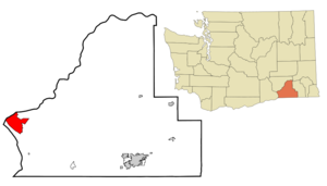
mapsize = 250px
map_caption = Location of Burbank, Washington
mapsize1 =
map_caption1 =subdivision_type = Country
subdivision_name =United States
subdivision_type1 = State
subdivision_name1 =Washington
subdivision_type2 = County
subdivision_name2 = Walla Wallagovernment_footnotes =
government_type =
leader_title =
leader_name =
leader_title1 =
leader_name1 =
established_title =
established_date =unit_pref = Imperial
area_footnotes =area_magnitude =
area_total_km2 = 38.8
area_land_km2 = 34.4
area_water_km2 = 4.4
area_total_sq_mi = 15.0
area_land_sq_mi = 13.3
area_water_sq_mi = 1.7population_as_of = 2000
population_footnotes =
population_total = 3303
population_density_km2 = 96.1
population_density_sq_mi = 249.0timezone = Pacific (PST)
utc_offset = -8
timezone_DST = PDT
utc_offset_DST = -7
elevation_footnotes =
elevation_m = 114
elevation_ft = 374
latd = 46 |latm = 11 |lats = 43 |latNS = N
longd = 119 |longm = 0 |longs = 2 |longEW = Wpostal_code_type =
ZIP code
postal_code = 99323
area_code = 509
blank_name = FIPS code
blank_info = 53-08780GR|2
blank1_name = GNIS feature ID
blank1_info = 1512048GR|3
website =
footnotes =Burbank is a
census-designated place (CDP) in Walla Walla County,Washington , where theSnake River meets the Columbia. The population was 3,303 at the 2000 census. The city is located just east of Pasco, and north ofKennewick , across the Snake and Columbia Rivers, respectively. Kennewick and Pasco are two of the Tri-Cities, and although Burbank is much smaller than either of the two cities, generally Burbank can be considered to be part of the Tri-Cities metropolitan area.Chuck Palahniuk andJeremy Bonderman grew up in Burbank.Geography
Burbank Washington is located at coor dms|46|11|43|N|119|0|2|W|city (46.195392, -119.000477)GR|1.
According to the
United States Census Bureau , the CDP has a total area of 15.0square mile s (38.8km² ), of which, 13.3 square miles (34.4 km²) of it is land and 1.7 square miles (4.4 km²) of it (11.36%) is water.Demographics
As of the
census GR|2 of 2000, there were 3,303 people, 1,089 households, and 908 families residing in the CDP. Thepopulation density was 249.0 people per square mile (96.1/km²). There were 1,124 housing units at an average density of 84.7/sq mi (32.7/km²). The racial makeup of the CDP was 90.16% White, 0.30% African American, 0.82% Native American, 0.36% Asian, 0.12% Pacific Islander, 5.81% from other races, and 2.42% from two or more races. Hispanic or Latino of any race were 9.93% of the population.There were 1,089 households out of which 41.7% had children under the age of 18 living with them, 71.7% were married couples living together, 7.3% had a female householder with no husband present, and 16.6% were non-families. 13.1% of all households were made up of individuals and 5.3% had someone living alone who was 65 years of age or older. The average household size was 3.03 and the average family size was 3.29.
In the CDP the population was spread out with 31.1% under the age of 18, 7.6% from 18 to 24, 28.8% from 25 to 44, 24.6% from 45 to 64, and 8.0% who were 65 years of age or older. The median age was 35 years. For every 100 females there were 100.2 males. For every 100 females age 18 and over, there were 100.5 males.
The median income for a household in the CDP was $50,522, and the median income for a family was $52,146. Males had a median income of $40,343 versus $28,580 for females. The
per capita income for the CDP was $17,105. About 3.4% of families and 6.5% of the population were below thepoverty line , including 11.5% of those under age 18 and none of those age 65 or over.References
External links
* [http://members.aol.com/Gibson0817/burbank.htm Beth Gibson's history]
Wikimedia Foundation. 2010.