- College Place, Washington
-
College Place, Washington — City — Location of College Place, Washington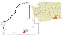
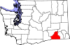
Coordinates: 46°2′42″N 118°22′57″W / 46.045°N 118.3825°WCoordinates: 46°2′42″N 118°22′57″W / 46.045°N 118.3825°W Country United States State Washington County Walla Walla Area - Total 2.4 sq mi (6.3 km2) - Land 2.4 sq mi (6.3 km2) - Water 0.0 sq mi (0.0 km2) Elevation 794 ft (242 m) Population (2010) - Total 8,765 - Density 3,232.2/sq mi (1,248.0/km2) Time zone Pacific (PST) (UTC-8) - Summer (DST) PDT (UTC-7) ZIP code 99324 Area code 509 FIPS code 53-13855[1] GNIS feature ID 1512107[2] College Place is a city in Walla Walla County, Washington, United States next to Walla Walla, Washington. The population was 8,765 at the time of the 2010 census.
College Place is the home of Walla Walla University, a Seventh-day Adventist college. Because of the primary Adventist population, most downtown businesses close on Saturday, reopening in most cases on Sunday. College Avenue is the main Street running North to South from Highway 12 to the Milton-Freewater Highway.
Contents
History
Martin Field, to the west of town, was an air training base during World War II. It is now a private airfield.
College Place was officially incorporated on January 19, 1946.
Geography
College Place is located at 46°2′42″N 118°22′57″W / 46.045°N 118.3825°W (46.045127, -118.382425).[3]
According to the United States Census Bureau, the city has a total area of 2.4 square miles (6.3 km²), all of it land.
Demographics
Historical populations Census Pop. %± 1970 4,510 — 1980 5,771 28.0% 1990 6,308 9.3% 2000 7,818 23.9% 2010 8,765 12.1% U.S. Census Bureau[4] As of the census[1] of 2000, there were 7,818 people, 2,909 households, and 1,870 families residing in the city. The population density was 3,232.2 people per square mile (1,247.3/km²). There were 3,134 housing units at an average density of 1,295.7 per square mile (500.0/km²). The racial makeup of the city was 86.83% White, 1.55% African American, 0.46% Native American, 1.75% Asian, 0.52% Pacific Islander, 6.28% from other races, and 2.61% from two or more races. Hispanic or Latino of any race were 12.74% of the population.
There were 2,909 households out of which 28.5% had children under the age of 18 living with them, 50.5% were married couples living together, 10.8% had a female householder with no husband present, and 35.7% were non-families. 29.4% of all households were made up of individuals and 11.9% had someone living alone who was 65 years of age or older. The average household size was 2.36 and the average family size was 2.93.
In the city the age distribution of the population shows 21.1% under the age of 18, 21.4% from 18 to 24, 23.2% from 25 to 44, 16.6% from 45 to 64, and 17.7% who were 65 years of age or older. The median age was 31 years. For every 100 females there were 91.6 males. For every 100 females age 18 and over, there were 87.8 males.
The median income for a household in the city was $30,330, and the median income for a family was $40,833. Males had a median income of $34,167 versus $25,871 for females. The per capita income for the city was $14,493. About 11.3% of families and 16.0% of the population were below the poverty line, including 17.8% of those under age 18 and 7.6% of those age 65 or over.
Notable people from College Place
- Dr. Charles E. Woodworth - ARS Researcher, Major
References
- ^ a b "American FactFinder". United States Census Bureau. http://factfinder.census.gov. Retrieved 2008-01-31.
- ^ "US Board on Geographic Names". United States Geological Survey. 2007-10-25. http://geonames.usgs.gov. Retrieved 2008-01-31.
- ^ "US Gazetteer files: 2010, 2000, and 1990". United States Census Bureau. 2011-02-12. http://www.census.gov/geo/www/gazetteer/gazette.html. Retrieved 2011-04-23.
- ^ "Selected Historical Decennial Counts". U.S. Census Bureau. http://www.census.gov/population/www/censusdata/hiscendata.html. Retrieved 15 August 2011.
Municipalities and communities of Walla Walla County, Washington County seat: Walla Walla Cities College Place | Waitsburg | Walla Walla
Town CDPs Unincorporated
communityCategories:- Cities in Washington (state)
- Populated places in Walla Walla County, Washington


Wikimedia Foundation. 2010.