- Blue Bridge (Washington)
Infobox Bridge
bridge_name = Blue Bridge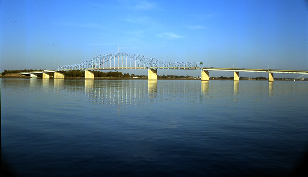
caption =
official_name = Pioneer Memorial Bridge
carries = Automobiles
crosses =Columbia River
locale = Kennewick-Pasco, Washington
maint = Washington State Dept. of Transportation
id =
designer =
design =Truss bridge
material = Concrete/steel
spans =
pierswater =
mainspan = convert|60|ft|m|1|abbr=on
length = convert|2521|ft|m|1|abbr=on
width =
height =
load =
clearance =
below =
traffic =
begin =September 19 ,1951
complete =
open =July 30 ,1954
closed =
toll =
map_cue =
map_
map_text =
map_width =
coordinates = coord|46|13|10.38|N|119|6|14.54|W|region:US_type:landmark|display=inline,title
lat =
long = The Blue Bridge (officially named the Pioneer Memorial Bridgecite web | url=http://www.historylink.org/essays/output.cfm?file_id=7818 | title=Officials dedicate the Pioneer Memorial Bridge (Blue Bridge) spanning the Columbia between Kennewick and Pasco on July 30, 1954 | publisher=HistoryLink | first=Elizabeth | last=Gibson | date=September 7 ,2006 | accessdate=2008-05-27] ) is a four-lane arch-truss bridge connecting Pasco,Washington to Kennewick,Washington . U.S. Route 395 crosses theColumbia River via this bridge. The name comes from theblue paint used on the truss superstructure, with white paint on the suspension beams. The bridge was painted green at time of construction (green being the state color of Washington). It is one of three bridges connecting Pasco to the other members of theTri-Cities of Washington (Kennewick and Richland), along with theCable Bridge to the east and theInterstate 182 Bridge from Richland to the northwest.History
The bridge was first proposed in 1949 as the previous bridge (commonly referred to as the 'Green Bridge') was unable to handle the 10,000+ cars that were crossing it daily. Work on the bridge was begun in 1951. Work was completed in the summer of 1954 with a total cost of about $7 million. The bridge was dedicated on July 30, 1954. A
United States flag flies atop the bridge, which was added during the re-decking of the bridge in 1989.The Blue Bridge is also home to the most
car accident s in the entire Tri-Cities area, with one occurring almost every three days.fact|date=May 2008 Duringrush hour , the junction of U.S Route 395 and State Route 240 on the southbound side of the bridge is especially crowded. Late in 2005, it was announced that funding had been obtained in order to remedy the situation, by modifying the approaches and exits to the bridge, especially at the Highway 395 southbound exit on the Kennewick side of the bridge. [cite news | url=http://www.tcrepublic.com/news.php?nid=98 | title= Interchange south of Blue Bridge to be widened | publisher=Tri-Cities Republic | date=March 13 2006 | accessdate=2008-05-27]In 2002, the bridge was listed on the
National Register of Historic Places (#02000241).References
Wikimedia Foundation. 2010.