- Interstate 49
-
Interstate 49

Route information Maintained by Louisiana Department of Transportation Length: 208.25 mi[1] (335.15 km) Existed: 1984 – present Major junctions South end: 
 I-10 / US 167 in Lafayette
North end:  I-20 in Shreveport
Highway system Main route of the Interstate Highway System
Main • Auxiliary • Business←  LA 48
LA 48LA 49  →
→Interstate 49 (I-49) is currently an intrastate Interstate Highway located entirely within the state of Louisiana in the southern United States. Its southern terminus is in Lafayette, Louisiana, at Interstate 10 while its northern terminus is in Shreveport, Louisiana, at Interstate 20.
Contents
Route description
I-49 begins its journey in Lafayette concurrent with U.S. Route 167 from I-10 to Opelousas at Exit 23. At Lafayette, motorists continuing southbound see the interstate highway change to U.S. 167 (Evangeline Thruway), a major thoroughfare taking travelers towards the heart of Lafayette. North of Lafayette, motorists on I-49 will parallel the ancient Mississippi river bed north of Carencro, and through Grand Coteau, just south of Opelousas.
After leaving Opelousas, I-49 traverses the relatively flat, fertile farmlands until reaching Alexandria. From there, the highway roughly follows the Red River and Louisiana 1, bypassing the historic city of Natchitoches to the west on its way to Shreveport. At Shreveport, the highway parallels a railroad line just to the west until its terminus at I-20 southwest of downtown.
The heaviest traffic on I-49 occurs within the cities of Shreveport and Opelousas. The stretch of freeway in Shreveport sees an average of 70,000 vehicles per day, while the stretch of freeway between Lafayette and Carencro sees an average of 55,000 vehicles per day, and the stretch of freeway through Opelousas sees an average of 45,000 vehicles per day between the Judson Walsh Drive and Creswell Lane exits.
History
The original plans for Interstate Highways in Louisiana only included Interstates 10 and 20 with no connection in between. After Interstate 55 was added in the 1950s, the state considered building a toll road to connect I-10 in southwestern Louisiana and I-20 in the northern part of the state, but later rejected the idea.
In the mid 1970s, The Federal Highway Administration approved an Interstate Highway to run between I-10 and I-20, beginning at I-10 in Lafayette and ending at I-20 in Shreveport. The mileage was gained from mileage released from other highways the states did not build as well as 153 miles (246 km) from a supplemental reserve.[2]
Construction of I-49 began in the early 1980s, the first signed segment from I-10 to Washington, Louisiana, opened in 1984. After several delays, most of the highway was open by the early 1990s. The entire length of the 212-mile (341 km) road was completed May 1, 1996 when a 16.6-mile (26.7 km) section of highway in Alexandria named the Martin Luther King Jr. Highway was completed. The total cost of I-49's construction was about $1.38 billion.
Future

Long-term plans call for I-49 to be extended southeastward from Lafayette to New Orleans; and northward from Shreveport to Kansas City, Missouri. There, it will connect with the Interstate network there and provide a seamless freeway link from Louisiana ports to the Canadian border in North Dakota.
Construction for the extension north is already underway in southwest Missouri, northern and southwestern Arkansas, and in northern Louisiana.
These plans may result in pieces of this interstate being disconnected. Once Arkansas and Missouri finish the Bella Vista Bypass, mentioned below, both states plan to rename I-540/U.S. 71 as I-49[3] long before construction begins across west-central Arkansas, though the American Association of State Highway and Transportation Officials (AASHTO) denied the designation for the Missouri portion on September 28, 2007.[4]
Louisiana
Interstate 49 North is a 36-mile construction project that will connect I-220 in Shreveport to the Arkansas state line. This project has been divided into 11 segments. 9 of 11 segments are under construction as of February, 2011 and $460 million of $622 million needed to complete the project has been secured.[5]
State transportation officials are currently working on plans to extend Interstate 49 to the south and east, from Lafayette to New Orleans roughly following the path of the current U.S. 90, which is at present a four-lane divided highway between the two cities. However, from Morgan City to near Raceland, U.S. 90 is an interstate-standard freeway, bypassing Houma to the north.
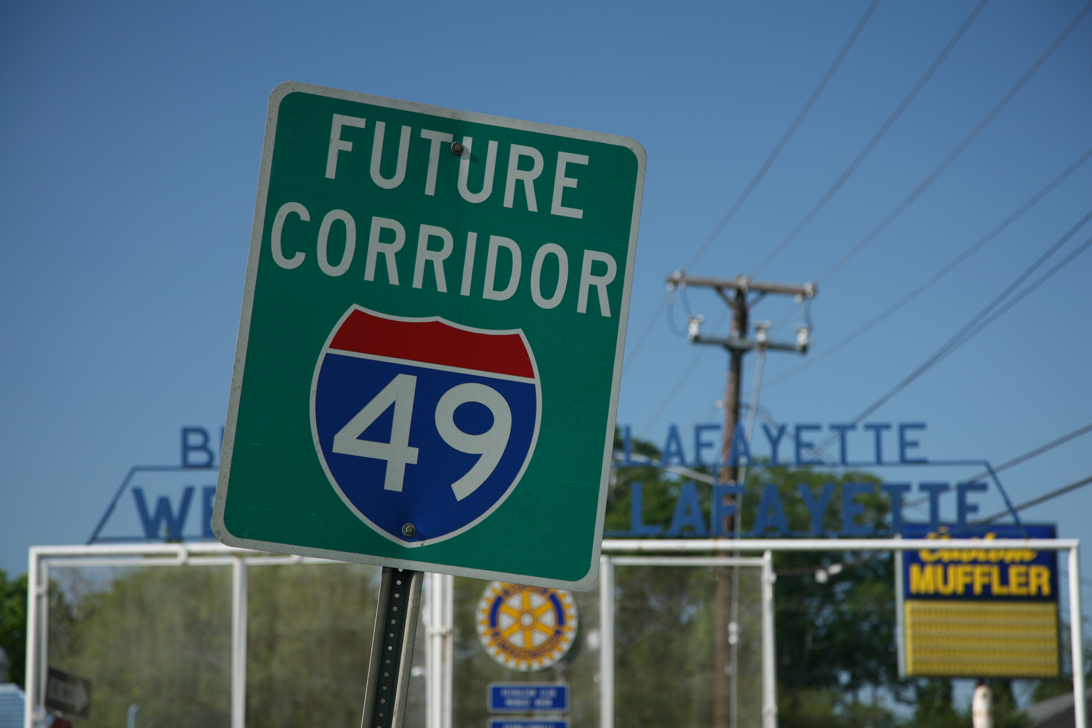
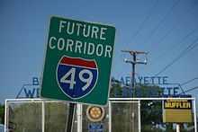 Future corridor I-49 sign in Lafayette, LA
In the Lafayette area, the project is divided into two projects, the I-49 Connector and the rest of the interstate from the Lafayette Regional Airport to LA 88. The I-49 Connector has a record of decision and is currently in the process of formulating the Environmental Impact Study. It is planned to be a six-lane elevated freeway, passing to the West of the current Evangeline Thruway corridor, as to be closer to the Central Business District in Downtown Lafayette. The rest of the freeway from the airport to LA 88 will be an at grade six-lane freeway with a two mile (3 km) segment of eight-lane elevated freeway through the suburb of Broussard.
In the immediate New Orleans area, I-49 is planned to follow the route of the U.S. 90 Business (also known locally as the Westbank Expressway) through Westwego, Gretna and across the Crescent City Connection into downtown New Orleans, ending at I-10. "Future I-49" signage is visible along U.S. 90 and U.S. 90 Business, although as of 2010, construction has yet to begin.
In addition to the southeastward extension, Louisiana officials are also working on clearing and grubbing and drainage for the new extension from Shreveport to the Arkansas line. The construction roughly parallels U.S. 71 northward from I-220. In Shreveport, I-49 is also proposed to be rerouted along Louisiana 3132/Inner Loop Expressway and concurrent with I-220 from I-20 to its proposed alignment near U.S. 71.[1] The stretch of the current I-49 between the Inner Loop and I-20 is likely to become an interstate spur. Plans are underway to connect I-49 at the I-20 interchange with I-49 North in the vicinity of the I-220 interchange. [2]
Arkansas
 AR 549 (Future I-49) under construction
In southern Arkansas State Highway 549 has been built to Interstate standards between Texarkana and Doddridge, 5 miles (8.0 km) from the state line. It is presently being constructed to complete the routing to the state line. A new segment extending northward from Texarkana, AR, crossing into Texas, over the Red River and back to Arkansas is now shown projected on the official 2009 Arkansas state map.[6]
Construction has not begun on the 180-mile section between Texarkana and Fort Smith. It is planned to follow the general route of U.S. 71 through the state between Interstate 30 and Interstate 40.
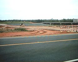
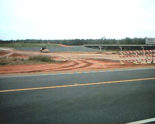
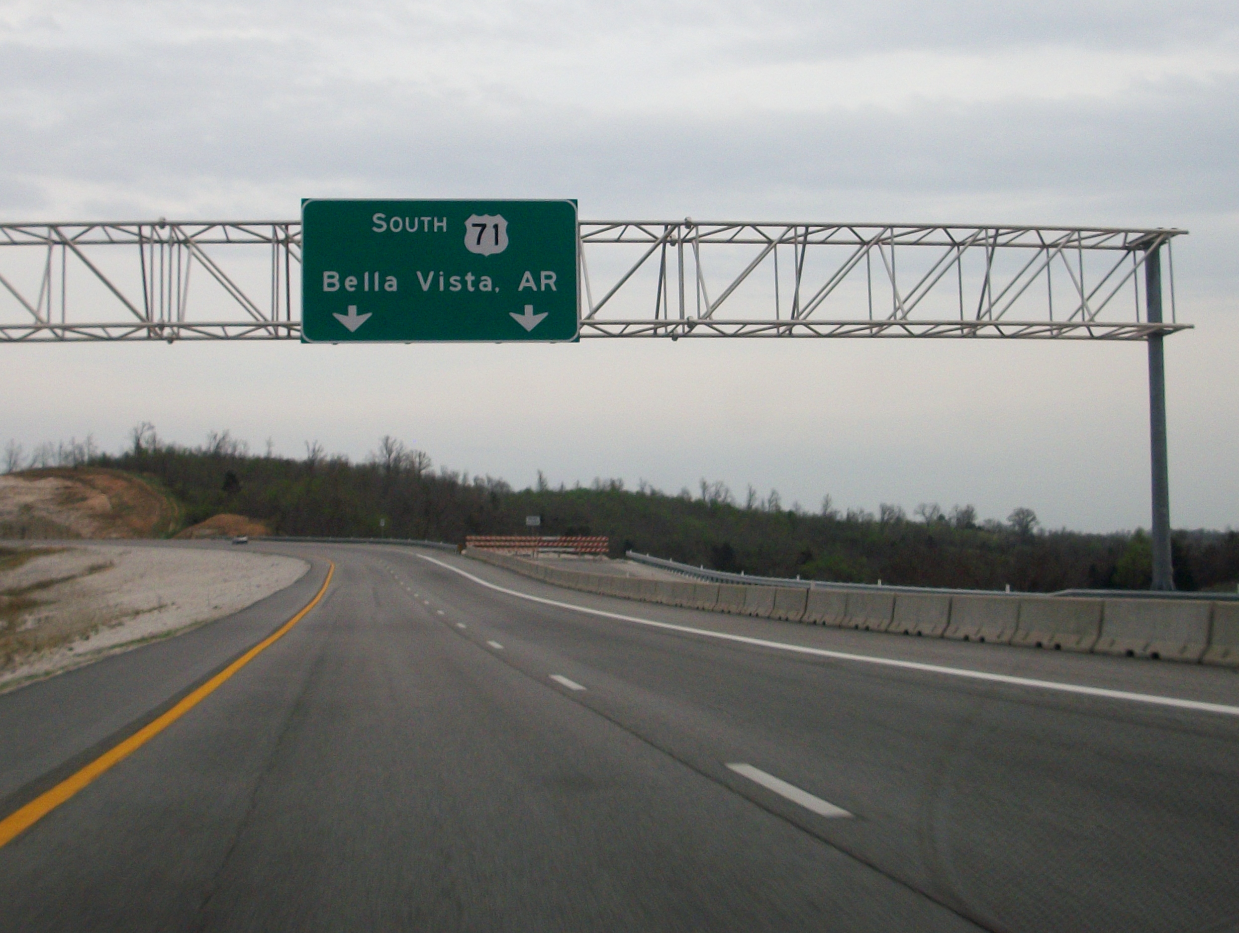
North of I-40, a map shows the two disconnected pieces of the Interstate. South of the interruption it is labeled I-540. The bypass being planned will go around Bella Vista. Many motorists in Arkansas and Missouri, especially truckers, are desperate to see the highway fully connected and flowing due to current traffic congestion. This section, however, was indefinitely postponed following a study showing that a toll would not be enough to pay for the highway. The Missouri Department of Transportation (MoDOT)[7] has said construction on their part of the Bella Vista Bypass would be on hold until Arkansas begins construction of its part. On August 11, 2010, the FHWA announced that a TIGER economic recovery grant had been approved for construction of the Bella Vista bypass and its extension to Pineville, MO, the southern end of the existing freeway in that state. It also directly referenced the corridor as I-49 in the text of that announcement; this effectively lays to rest any numbering controversy regarding the development of the New Orleans to Kansas City Interstate route.[8] Arkansas is beginning construction of the bypass to the Missouri state line.[9]
Missouri
 Closed ramp which will serve as the northern end of the Bella Vista Bypass upon completion.
In Missouri, all of U.S. 71 from Anderson to Joplin has already been upgraded to Interstate Highway standards. A short bypass of Joplin, Missouri Route 249 has also been built as an eastern city bypass but will not immediately become part of I-49 north, due to the traffic signals at the interchange with US 71 near Carthage.[10]
Heading north, many sections of divided highway still have at-grade intersections between Joplin and Harrisonville, yet are easily upgradeable. From Harrisonville to the south end of Kansas City at the Grandview Triangle—where U.S. 71 and Interstates 435 and 470 converge—the road is already built to Interstate Highway standards.
On August 4, 2010, the Missouri Department of Transportation announced that US-71 between Joplin and Kansas City will be upgraded to Interstate Standards and become Interstate 49 within the next two years. The portion of US-71 north of the Grandview Triangle will not be upgraded as part of this project.[11]
In central and southern Kansas City, much of U.S. 71, has been realigned to Bruce R. Watkins Drive, which connects the Interstate 70/Interstate 670 interchange in downtown Kansas City with south Kansas City with Interstate 435 and Interstate 470. Many neighborhood associations in Kansas City have objected to the upgrading U.S. 71 to freeway. Three at-grade intersections—Gregory Boulevard (71st Street), 59th Street and 55th Street—prevent the I-49 designation north of the Grandview Triangle along U.S. 71. MoDOT has gone on record stating a court order keeps them from removing the stoplights, making conversion of this stretch unlikely.[12]
Exit list
Parish Location # Destinations Notes Lafayette Lafayette US 167 south – LafayetteContinuation beyond I-10 1A-B I-10 – Baton Rouge, Lake CharlesSigned as Exits 1A (east) and 1B (west) 1C Pont des Mouton Road 2  LA 98 (Gloria Switch Road)
Carencro 4  LA 726 – Carencro
7  LA 182
St. Landry Grand Coteau 11  LA 93 – Sunset, Grand Coteau
Opelousas 15  LA 3233 (Harry Guilbeau Road)
17 Judson Walsh Drive 18  LA 31 (Creswell Lane)
19  US 190 – Baton Rouge, Port Barre, Opelousas
Signed as exits 19A (east) and 19B (west) northbound 23  US 167 north / LA 744 – Ville Platte
North end of US 167 overlap Washington 25  LA 103 – Washington, Port Barre
27  LA 10 – Lebeau, Washington
40  LA 29 – Ville Platte
Avoyelles 46  LA 106 – St. Landry
53  LA 115 – Bunkie
Rapides 56  LA 181 – Cheneyville
61 US 167 – Turkey Creek, Meeker66  LA 112 – Forest Hill, Lecompte
73 
 LA 3265 / PR 22 – Woodworth
80 


 US 167 south / US 71 / US 167 Bus. north (MacArthur Drive)
South end of US 167 overlap; southbound exit to US 71 north is via exit 81 Alexandria 81  LA 3250 (Sugarhouse Road)
Southbound exit and northbound entrance 83 Broadway Avenue 84 

 LA 1 / LA 28 Bus. / Casson Street
Southbound exit is via exit 85A. LA 1 southbound is also the Zachary Taylor Parkway, which starts here. 84 US 167 north / LA 28 east (Pineville Expressway)North end of US 167 overlap; south end of LA 28 overlap 85A M.L. King Drive, Elliott Street – Downtown Alexandria 85B Monroe Street, Medical Center Drive Northbound exit and southbound entrance 86  US 71 / US 165 / LA 28 west (MacArthur Drive) – Fort Polk, Leesville
90  LA 498 (Alexandria International Airport access)
94  PR 23 (Rapides Station Road)
98 LA 1 – BoyceNorthbound exit and southbound entrance 99 
 LA 8 east / LA 1200 – Boyce
South end of LA 8 overlap 103 LA 8 west – FlatwoodsNorth end of LA 8 overlap 107 Lena Natchitoches 113  LA 490 – Chopin
119  LA 119 – Cloutierville
127  LA 120 – Flora, Cypress
Natchitoches 132  LA 478
138  LA 6 – Many, Natchitoches
142  PR 547 (Posey Road)
148  LA 485 – Allen, Powhatan
155  LA 174 – Ajax, Lake End
De Soto 162 
 US 371 / LA 177 – Pleasant Hill, Coushatta
169 Asseff Road 172  US 84 – Mansfield, Grand Bayou
177  LA 509 – Carmel
186  LA 175 – Kingston, Frierson
191 
 LA 3276 / PR 16 – Stonewall
Caddo 196 Southern Loop Shreveport 199  LA 526 (Bert Kouns Industrial Loop)
201  LA 3132 (Inner Loop Expressway) – Dallas, Texarkana
202  LA 511 (East 70th Street)
203 Hollywood Avenue, Pierremont Road 205 Kings Highway 206 I-20 – Dallas, MonroeNorthbound exit and southbound entrance Pete Harris Drive, Murphy Street At-Grade Intersection References
- ^ Federal Highway Administration (2002-10-31). "FHWA Route Log and Finder List: Table 1". http://www.fhwa.dot.gov/reports/routefinder/table1.htm. Retrieved 2007-03-28.
- ^ 50th Anniversary Interstate Highway System: Previous Facts of the Day Federal Highway Administration. retrieved 27 May 2007.
- ^ Kennedy, Wally. Plan holds 2008 finish for Range Line Bypass, The Joplin (MO) Globe, published 11 May 2007.
- ^ "Report for SCOH: AASHTO Annual Meeting September 29, 2007". Special Committee on U.S. Route Numbers and Interstate Highways, American Association of State Highway and Transportation Officials, 2007-09-29. Retrieved on 2010-08-02.
- ^ http://www.dotd.la.gov/administration/public_info/projects/i49north/
- ^ http://www.arkansashighways.com/planning_research/mapping_graphics/statehwymap_state09.PDF
- ^ http://www.modot.mo.gov/
- ^ http://www.fhwa.dot.gov/pressroom/fhwa1032.htm
- ^ http://www.thecitywire.com/index.php?q=node/11245
- ^ "Converting Route 71 to I-49." Missouri Department of Transportation. Information. Retrieved May 11, 2011.
- ^ http://webcache.googleusercontent.com/search?q=cache:Zl8wjcRkkWAJ:www.kansascity.com/2010/08/04/2129341/missouri-will-upgrade-us-71-to.html+www.kansascity.com/2010/08/04/2129341/missouri-will-upgrade-us-71-to.html&cd=1&hl=en&ct=clnk&gl=us
- ^ http://modotblog.blogspot.com/2009/02/missouri-has-first-in-nation-economic.html?showComment=1235573580000#c8280429300854348747
External links
- Interstate Guide: I-49
- I-49 Energy Corridor
- I-49 North (Louisiana Department of Transportation and Development)
- I 49 Report
- I-49 Inner-City Connector-Shreveport
- I-49 Inner City Connector map (Shreveport, LA)
- I-49 South Project
- I-49 Connector (Lafayette, LA)
- Future I-49 South Pictures (Stephen Gantry)
- Future I-49 South Pictures (Andy P. Jung)
Main Interstate Highways (major interstates highlighted)
4 5 8 10 12 15 16 17 19 20 22 24 25 26 27 29 30 35 37 39 40 43 44 45 49 55 57 59 64 65 66 68 69 70 71 72 73 74 75 76 (W) 76 (E) 77 78 79 80 81 82 83 84 (W) 84 (E) 85 86 (W) 86 (E) 87 88 (W) 88 (E) 89 90 91 93 94 95 96 97 99 H-1 H-2 H-3 Unsigned A-1 A-2 A-3 A-4 PRI-1 PRI-2 PRI-3 Lists Primary Main - Intrastate - Suffixed - Temporary - Future - Gaps Auxiliary Main - Future - Unsigned Other Standards - Business - Bypassed - Tolled City of Shreveport & Shreveport/Bossier City Metro Freeways Topics Shreveport
NeighborhoodsDowntown | Riverfront District | Highlands | Shreve City | Anderson Island | Broadmoor | Shreve Island | Southern Hills | Jewella-South Park | Cross Lake | LSUS-University Area | Greenwood | Blanchard | Texas Border
The Ark-La-Tex Shreveport | Bossier City | Texarkana | Atlanta | Stonewall | Mansfield | Minden | Homer | Haynesville | Magnolia | Hope | Waskom | Marshall | Longview | Jefferson | Carthage | Nacogdoches | Coushatta | Natchitoches |
New Orleans Highways Radial Non-freeways Other Interstate Highways in Louisiana Signed Future Cancelled Categories:- Interstate 49
- Interstate Highway System
- Interstate Highways in Louisiana


Wikimedia Foundation. 2010.