- Cheneyville, Louisiana
-
Town of Cheneyville Town 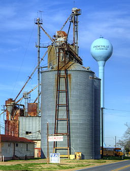
Country United States State Louisiana Parish Rapides Elevation 66 ft (20.1 m) Coordinates 31°00′48″N 92°17′22″W / 31.01333°N 92.28944°W Area 1.0 sq mi (2.6 km2) - land 1.0 sq mi (3 km2) - water 0.0 sq mi (0 km2), 0% Population 901 (2000) Density 863.9 / sq mi (333.6 / km2) Timezone CST (UTC-6) - summer (DST) CDT (UTC-5) Area code 318 
 Location of Cheneyville in Louisiana
 Location of Louisiana in the United States
Cheneyville is a town in Rapides Parish, Louisiana, United States. It is part of the Alexandria, Louisiana Metropolitan Statistical Area. The population was 901 at the 2000 census.
The Louisiana historian, Sue Eakin, is interred at Cheneyville in the Trinity Episcopal Church Cemetery.[1]
The Louisiana physician and politician Alvan Lafargue practiced medicine in Cheneyville after 1910.[2]
Contents
History
The town was named for settler William Cheney.[3]
Geography
According to the United States Census Bureau, Cheneyville has a total area of 1.0 square mile (2.6 km2), all of it land.
Demographics
As of the census[4] of 2000, there were 901 people, 267 households, and 183 families residing in the town. The population density was 863.9 people per square mile (334.5/km²). There were 314 housing units at an average density of 301.1 per square mile (116.6/km²). The racial makeup of the town was 33.07% White, 65.70% African American, 0.33% Native American, 0.55% from other races, and 0.33% from two or more races. Hispanic or Latino of any race were 2.33% of the population.
There were 267 households out of which 28.5% had children under the age of 18 living with them, 39.7% were married couples living together, 26.2% had a female householder with no husband present, and 31.1% were non-families. 28.5% of all households were made up of individuals and 14.6% had someone living alone who was 65 years of age or older. The average household size was 2.71 and the average family size was 3.39.
In the town the population was spread out with 24.0% under the age of 18, 10.2% from 18 to 24, 30.4% from 25 to 44, 22.6% from 45 to 64, and 12.8% who were 65 years of age or older. The median age was 36 years. For every 100 females there were 103.8 males. For every 100 females age 18 and over, there were 102.1 males.
The median income for a household in the town was $19,044, and the median income for a family was $21,917. Males had a median income of $21,250 versus $12,159 for females. The per capita income for the town was $10,244. About 29.4% of families and 43.9% of the population were below the poverty line, including 46.2% of those under age 18 and 27.0% of those age 65 or over.
References
- ^ "Obituary of Sue Lyles Eakin". melanconfunerals.com. http://www.melanconfunerals.com/index.cfm. Retrieved 3-September 21, 2009.
- ^ "Lafargue, Alvan Henry". Louisiana Historical Assocaition, A Dictionary of Louisiana Biography. http://www.lahistory.org/site29.php. Retrieved February 17, 2011.
- ^ "Profile for Cheneyville, Louisiana". ePodunk. http://www.epodunk.com/cgi-bin/genInfo.php?locIndex=3305. Retrieved 2010-06-14.
- ^ "American FactFinder". United States Census Bureau. http://factfinder.census.gov. Retrieved 2008-01-31.
Municipalities and communities of Rapides Parish, Louisiana Cities 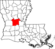
Towns Villages CDP Unincorporated
communitiesCategories:- Populated places in Rapides Parish, Louisiana
- Towns in Louisiana
- Populated places in Louisiana with African American majority populations
- Alexandria, Louisiana metropolitan area


Wikimedia Foundation. 2010.