- Coos County, Oregon
-
Coos County, Oregon 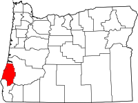
Location in the state of Oregon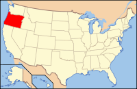
Oregon's location in the U.S.Founded December 22, 1853 Seat Coquille Area
- Total
- Land
- Water
1,806 sq mi (4,678 km²)
1,600 sq mi (4,144 km²)
206 sq mi (534 km²), 11.40%Population
- (2010)
- Density
63,043
39/sq mi (15/km²)Website [http://www.co.coos.or.us www.co.coos.or.us] Coos County is a county located in the U.S. state of Oregon. In 2010, its population was 63,043. It is named after a tribe of Native Americans who lived in the region. The county was formed from the western parts of Umpqua and Jackson counties. The county seat is Coquille.
Contents
History
It's unclear where the name Coos originated. Lewis and Clark noted Cook-koo-oose.[citation needed] Early maps and documents spelled it Kowes, Cowes, Coose, Koos, among others.[citation needed]
Although exploration and trapping in the area occurred as early as 1828, the first settlement was established at Empire City in 1853, now part of Coos Bay, Oregon, by members of the Coos Bay Company.
Coos County was created by the Territorial Legislature from parts of Umpqua County, Oregon and Jackson County, Oregon Counties on December 22, 1853. Curry County, Oregon was created from the southern part in 1855. The county seat was originally at Empire City. In 1895 the legislature permitted the citizens of the county to choose a new county seat. The 1896 vote resulted in moving the seat to Coquille.
The Territorial Legislature granted permission for the development of wagon roads from Coos Bay to Jacksonville, Oregon in 1854 and to Roseburg, Oregon in 1857.
Economy
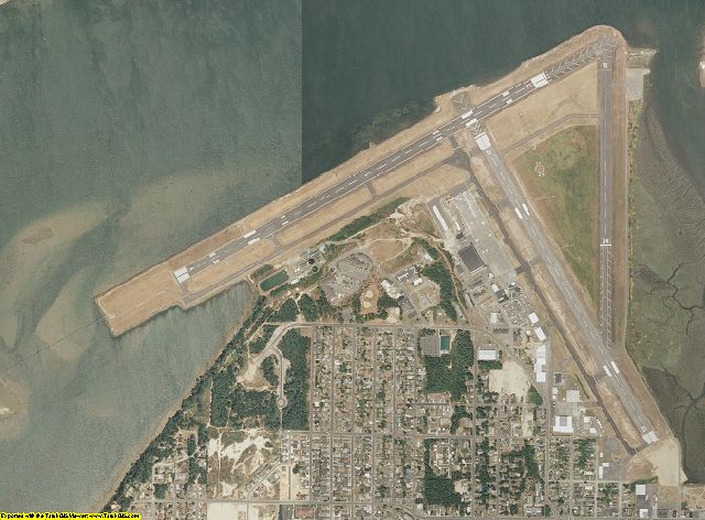
 A landing strip or airport runway in Coos County
Deposits of gold initially attracted people to the county in the nineteenth century. Between 1890 and 1910, large amounts of coal were mined in the county and shipped to California; production decreased after oil was discovered in that state, and no coal mines in the county have been in production since 1950. These coal fields have been explored for natural gas since 1938, although CDX Gas, a company based in Texas announced in 2003 that they would be drilling two test wells later that year.
A project to build a 60-mile (97 km) natural gas pipeline between the cities of Roseburg and Coos Bay, which would attract new industry to the Coos Bay area, was begun in 1999 when voters approved a local bond measure to raise as much as $27 million, with the state of Oregon providing $24 million. The pipeline construction began in June 2003 and was finished in 2004.
Currently, forest products, tourism, fishing and agriculture dominate the Coos County economy. The service industry is replacing the former lumber-driven economy. Bandon Dunes Golf Resort, north of Bandon and south of Coos Bay, attracts tourists and golfers from around the world. Boating, dairy farming, myrtlewood manufacturing, shipbuilding and repair and agriculture specialty products, including cranberries, also play an important role. Untapped rich deposits of iron ore, and lead await development.
Two projects are currently under development in Coos County. The first and most advanced economic change in the future of the area is the Jordan Cove Energy Project which includes the development of a shipping terminal on the north spit of Coos Bay, a half billion dollar terminal facility and a pipeline to deliver liquefied natural gas to southern Oregon and northern California. This endeavor will create up to 60 permanent new jobs and require a construction period of nearly 3 years and employ a 1,000 people at peak construction.[1] The second project making process is a mineral sands reclamation project headed by Oregon Resources Corporation. The company will use modern strip mining techniques to extract chromite, zircon, and garnet from local sands. The tailings after processing will be returned and re-contoured to replicate pre-mining conditions and subsequently reforested. Job numbers are not listed on the company website but an annual payroll of 3.5 million dollars is listed in the economic impact portion of the FAQ.[2]
There are several port districts in the county: Port of Coos Bay founded in 1909, Port of Coquille River founded in 1912, and Port of Bandon founded in 1913. Coos Bay is considered the best natural harbor between San Francisco Bay and the Puget Sound, and the Port of Coos Bay was the largest forest products shipper in the world until late 2005 when raw log exports via transport ship were suspended.
Demographics
Historical populations Census Pop. %± 1860 445 — 1870 1,644 269.4% 1880 4,834 194.0% 1890 8,874 83.6% 1900 10,324 16.3% 1910 17,959 74.0% 1920 22,257 23.9% 1930 28,373 27.5% 1940 32,466 14.4% 1950 42,265 30.2% 1960 54,955 30.0% 1970 56,515 2.8% 1980 64,047 13.3% 1990 60,273 −5.9% 2000 62,779 4.2% 2010 63,043 0.4% [3][4][5] As of the census[6] of 2000, there were 62,779 people, 26,213 households, and 17,457 families residing in the county. The population density was 39 people per square mile (15/km²). There were 29,247 housing units at an average density of 18 per square mile (7/km²). The racial makeup of the county was 91.97% White, 0.31% Black or African American, 2.41% Native American, 0.90% Asian, 0.17% Pacific Islander, 1.06% from other races, and 3.17% from two or more races. 3.40% of the population were Hispanic or Latino of any race. 18.5% were of German, 12.4% English, 11.3% Irish and 10.7% United States or American ancestry according to Census 2000. 96.0% spoke English and 2.5% Spanish as their first language.
There were 26,213 households out of which 26.00% had children under the age of 18 living with them, 52.90% were married couples living together, 9.90% had a female householder with no husband present, and 33.40% were non-families. 27.20% of all households were made up of individuals and 12.30% had someone living alone who was 65 years of age or older. The average household size was 2.34 and the average family size was 2.80.
In the county, the population dispersal was 21.90% under the age of 18, 7.10% from 18 to 24, 24.00% from 25 to 44, 27.80% from 45 to 64, and 19.10% who were 65 years of age or older. The median age was 43 years. For every 100 females there were 96.10 males. For every 100 females age 18 and over, there were 93.90 males. The median income for a household in the county was $31,542, and the median income for a family was $38,040. Males had a median income of $32,509 versus $22,519 for females. The per capita income for the county was $17,547. About 11.10% of families and 15.00% of the population were below the poverty line, including 19.90% of those under age 18 and 9.40% of those age 65 or over.
Natural history
The tallest documented living specimen of a Douglas-fir tree in the world is found 35 miles (56 km) southeast of Coos Bay in the Sitkum area[7] and is slightly more than 100 meters tall.[8]
Adjacent counties
- Douglas County - north and east
- Curry County - south

Douglas County Pacific Ocean 
Douglas County  Coos County, Oregon

Curry County National protected areas
- Bandon Marsh National Wildlife Refuge
- Oregon Islands National Wildlife Refuge (part)
- Siskiyou National Forest (part)
- Siuslaw National Forest (part)
Communities
Incorporated cities
Unincorporated communities and CDPs
- Allegany
- Arago
- Barview
- Bridge
- Broadbent
- Bunker Hill
- Charleston
- Green Acres
- Hauser
- Laurel Grove
- Leneve
- Libby
- McKinley
- Millington
See also
- National Register of Historic Places listings in Coos County, Oregon
- Steamboats of the Coquille River
- Steamboats of Coos Bay
References
- ^ http://www.jordancoveenergy.com/
- ^ http://www.oregon-resources.com/
- ^ http://www.census.gov/population/www/censusdata/cencounts/files/or190090.txt
- ^ http://factfinder2.census.gov
- ^ http://mapserver.lib.virginia.edu/
- ^ "American FactFinder". United States Census Bureau. http://factfinder.census.gov. Retrieved 2008-01-31.
- ^ Oregon Register of Big Trees
- ^ Hogan, C. Michael (2008) Douglas-fir: "Pseudotsuga menzesii", GlobalTwitcher.com, ed. N. Stromberg
External links
- Coos County, Oregon (official website)
- Coos Historical & Maritime Museum
- COOSonline.com (free online community)
Coordinates: 43°11′N 124°05′W / 43.18°N 124.09°W
Municipalities and communities of Coos County, Oregon Cities Bandon | Coos Bay | Coquille | Lakeside | Myrtle Point | North Bend | Powers
CDPs Unincorporated
communitiesAllegany | Arago | Bridge | Broadbent | Charleston | Dellwood | Dora | Fairview | Gaylord | Gravelford | Green Acres | Hauser | Laurel Grove | Leneve | Libby | McKinley | Millington | Norway | Prosper | Remote | Riverton | Sitkum | Sumner
Categories:- Oregon counties
- Coos County, Oregon
- 1853 establishments in the United States


Wikimedia Foundation. 2010.