- Curry County, Oregon
-
Curry County, Oregon 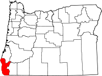
Location in the state of Oregon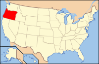
Oregon's location in the U.S.Founded December 18, 1855 Seat Gold Beach Area
- Total
- Land
- Water
1,989 sq mi (5,151 km²)
1,627 sq mi (4,214 km²)
361 sq mi (935 km²), 18.16%Population
- (2010)
- Density
22,364
14/sq mi (5.3/km²)Website www.co.curry.or.us Curry County is a county located in the U.S. state of Oregon. In 2010, its population was 22,364. The county is named for George Law Curry, a governor of the Oregon Territory. The seat of the county is Gold Beach.
Contents
Economy
In 1852 explorers discovered gold and other precious metals in the rivers and along the beaches of this area. As a result, settlement in the county was concentrated along the coast, depending primarily on water transportation. The slow development of inland transportation routes kept the county relatively isolated well into the twentieth century. While there is still some mining of cobalt, nickel, and chromium in the Gasaquet Mountain area, the economy has reoriented to agriculture and timber. Port Orford cedar (also known as Lawson's Cypress) and myrtlewood are important export products.
The county has excellent grazing areas for raising cattle and sheep. The county also produces blueberries, horticultural nursery stock, and 90% of all Easter lilies raised in the United States. In 2001, the native tanoak in the county were afflicted by Sudden oak death, caused by infection of Phytophthora ramorum, which has threatened the success of the local nurseries; however, the infection has been successfully contained to an area 12 miles (19 km) in size. Tourism is also important to Curry County. The Forest Service owns 59% of the land within the county boundaries. The Port of Brookings is considered one of the safest harbors on the coast.
Geography and ecology
The county originally contained about 1,500 square miles (3,900 km2). However, boundary adjustments with Coos County in 1872 and 1951 and Josephine County in 1880 and 1927 increased the area to 1,989 square miles (5,151.5 km2). 1,627 square miles (4,213.9 km2) is land and 361 square miles (935.0 km2) (18.16%) is water.
Located in Curry County is Cape Blanco, the westernmost point in the lower 48 states, with a longitude of 124 degrees, 33 minutes and 46 seconds.
The county contains significant forest extents, with occurrence of Black oak, Big leaf maple and Douglas-fir. The Blue Oak, prevalent slightly further south does not reach into Curry County.[1]
Adjacent counties
- Coos County, Oregon - (north)
- Douglas County, Oregon - (northeast)
- Josephine County, Oregon - (east)
- Del Norte County, California - (south)
National protected areas
- Oregon Islands National Wildlife Refuge
- Siskiyou National Forest (part)
Demographics
Historical populations Census Pop. %± 1860 393 — 1870 504 28.2% 1880 1,208 139.7% 1890 1,709 41.5% 1900 1,868 9.3% 1910 2,044 9.4% 1920 3,025 48.0% 1930 3,257 7.7% 1940 4,301 32.1% 1950 6,048 40.6% 1960 13,983 131.2% 1970 13,006 −7.0% 1980 16,992 30.6% 1990 19,327 13.7% 2000 21,137 9.4% 2010 22,364 5.8% [2][3][4] As of the census[5] of 2000, there were 21,137 people, 9,543 households, and 6,183 families residing in the county. The population density was 13 people per square mile (5/km²). There were 11,406 housing units at an average density of 7 per square mile (3/km²). The racial makeup of the county was 92.89% White, 0.15% Black or African American, 2.14% Native American, 0.70% Asian, 0.11% Pacific Islander, 1.11% from other races, and 2.90% from two or more races. 3.60% of the population were Hispanic or Latino of any race. 20.1% were of German, 13.8% English, 10.3% United States or American and 9.9% Irish ancestry according to Census 2000. 95.9% spoke English and 2.5% Spanish as their first language.
There were 9,543 households out of which 20.90% had children under the age of 18 living with them, 54.50% were married couples living together, 7.20% had a female householder with no husband present, and 35.20% were non-families. 29.70% of all households were made up of individuals and 14.70% had someone living alone who was 65 years of age or older. The average household size was 2.19 and the average family size was 2.66.
In the county, the population was spread out with 19.20% under the age of 18, 4.80% from 18 to 24, 20.00% from 25 to 44, 29.40% from 45 to 64, and 26.60% who were 65 years of age or older. The median age was 49 years. For every 100 females there were 96.60 males. For every 100 females age 18 and over, there were 94.80 males.
The median income for a household in the county was $30,117, and the median income for a family was $35,627. Males had a median income of $31,772 versus $22,416 for females. The per capita income for the county was $18,138. About 9.70% of families and 12.20% of the population were below the poverty line, including 13.60% of those under age 18 and 10.60% of those age 65 or over.
Communities
Incorporated cities
Unincorporated communities and CDPs
- Agness
- Bagnell Ferry
- Carpenterville
- Denmark
- Harbor
- Hunter Creek
- Illahe
- Langlois
- Marial
- Nesika Beach
- Ophir
- Pistol River
- Plum Trees
- Sixes
- Wedderburn
See also
- National Register of Historic Places listings in Curry County, Oregon
- Siskiyou National Forest
- USS Curry County (LST-685)
References
- ^ C. Michael Hogan (2008) Blue Oak: Quercus douglasii, GlobalTwitcher.com, ed. N. Stromberg
- ^ http://www.census.gov/population/www/censusdata/cencounts/files/or190090.txt
- ^ http://factfinder2.census.gov
- ^ http://mapserver.lib.virginia.edu/
- ^ "American FactFinder". United States Census Bureau. http://factfinder.census.gov. Retrieved 2008-01-31.
External links
Municipalities and communities of Curry County, Oregon Cities 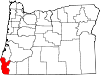
CDP Unincorporated
communitiesAgness | Carpenterville | Denmark | Illahe | Langlois | Marial | Nesika Beach | Ophir | Pistol River | Sixes | Wedderburn
Categories:- Oregon counties
- Curry County, Oregon
- 1855 establishments in the United States


Wikimedia Foundation. 2010.